Luanda Province
| Luanda | |
|---|---|
| Province | |
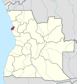 Luanda, province of Angola | |
| Country | Angola |
| Capital | Luanda |
| Government | |
| • Governor | Francisco Higino Lopes Carneiro |
| Area | |
| • Total | 18,835 km2 (7,272 sq mi) |
| Population | |
| • Estimate (2018) | 7,976,907 [1] |
| ISO 3166 code | AO-LUA |
| Website |
www |
Luanda is a province of Angola.
Luanda is the capital of the province and the country of Angola.
Administration
In 2011 Luanda Province was subdivided into seven municipalities, namely, Luanda, Belas, Cacuaco, Cazenga, Icolo e Bengo, Quiçama and Viana.[2][3] In Just before 2017, another two municipalities were added, Talatona and Kilamba-Kiaxi respectively, giving the province 9 municipalities, 41 urban districts, and 14 communes.[4]
History
The original prewar Luanda Province grew in size during the 20th century due to the urbanization of Angola. It was divided into the provinces of Luanda and Bengo in 1980.[3][5]
The new reform of 2011 moved the municipalities Icolo e Bengo and Quiçama from Bengo to Luanda Province, so as the province has 3 neighboring ones instead of being surrounded by Bengo. The administrative reform significantly increased the land area of Luanda Province. It formerly had an area of 2,417 square kilometres (933 sq mi) and a reported population of 6,542,942 in 2014, before accounting for reorganization[1] Despite this, the city occupied 113 square kilometres (44 sq mi), or less than five percent of the total area of the former province.
Profile
Governors of the Luanda Province have included: Francisca Espírito Santo (c. 2009-2010),[6] Jose Maria dos Santos (c. 2011-2013), and Graciano Francisco Domingos (c. 2014).
The province has created the Instituto de Planeamento e Gestão Urbana de Luanda (IPGUL, Institute for urban planning and management of Luanda) as an independent organ for urban planning of the province.[7]
Geography
Municipalities
- Belas (1,077 square kilometres (416 sq mi))
- Cacuaco (335 square kilometres (129 sq mi))
- Cazenga (51 square kilometres (20 sq mi))
- Ícolo e Bengo (3,083 square kilometres (1,190 sq mi))
- Luanda (113 square kilometres (44 sq mi))
- Quiçama (13,562 square kilometres (5,236 sq mi))
- Viana (615 square kilometres (237 sq mi))[8]
- new since 2017: Talatona and Kilamba-Kiaxi
References
- 1 2 http://citypopulation.de/php/angola-admin.php via Instituto Nacional de Estatístiica, República de Angola (web)
- ↑ "Luanda" (in Portuguese). Luanda, Angola: Info-Angola. 2013. Archived from the original on 6 November 2013. Retrieved 26 December 2013.
- 1 2 National Assembly of Angola (27 July 2011). "Lei n.º 29/11 de 1 de Setembro - Alteração da Divisão Político-Administrativa das províncias de Luanda e Bengo" [Law to change the politico-administrative divisions of Luanda and Bengo provinces] (PDF) (in Portuguese). IPGUL 'Noticias'. Retrieved 20 March 2012. While the law had been voted on July 27, 2011, its effective date is 60 days after publication in the Official Journal, which happened on September 1, 2011.
- ↑ http://www.redeangola.info/luanda-volta-a-ter-9-municipios/
- ↑ Broadhead, Susan (1992). Historical dictionary of Angola. Metuchen, N.J: Scarecrow Press. p. 119. ISBN 0585070091.
- ↑ "Perfil do Governador". Governo Provincial de Luanda (in Portuguese). Governo da República de Angola. Archived from the original on August 2010.
- ↑ "Informação sobre o IPGUL" [Information about the IGPUL] (in Portuguese). Retrieved 20 March 2012.
- ↑ "Divisão Político-Administrativa da Província de Luanda" (in Portuguese). Luanda, Angola: Info-Angola. 2013. Retrieved 26 December 2013.
External links
| Wikimedia Commons has media related to Luanda Province. |
- Official Governor of Luanda Province website
- Alternate official Luanda Province government website—(in Portuguese)
- Geoview.info: Luanda Province geography info
- Angolan ministry for territorial administration: Luanda Province
- IPGUL.org: Administrative map of Luanda Province with mapping those to old divisions]
- Official City of Luanda website—(in Portuguese)
- Info Angola.ao: Luanda Province information