Loppi
| Loppi | ||
|---|---|---|
| Municipality | ||
| Lopen kunta | ||
 Saint Bridget Church | ||
| ||
 Location of Loppi in Finland | ||
| Coordinates: 60°43′N 024°26.5′E / 60.717°N 24.4417°ECoordinates: 60°43′N 024°26.5′E / 60.717°N 24.4417°E | ||
| Country |
| |
| Region | Tavastia Proper | |
| Sub-region | Riihimäki sub-region | |
| Founded | 1632 | |
| Government | ||
| • Municipal manager | Karoliina Viitanen | |
| Area (2018-01-01)[1] | ||
| • Total | 655.97 km2 (253.27 sq mi) | |
| • Land | 597.62 km2 (230.74 sq mi) | |
| • Water | 58.36 km2 (22.53 sq mi) | |
| Area rank | 140th largest in Finland | |
| Population (2017-08-31)[2] | ||
| • Total | 8,067 | |
| • Rank | 125th largest in Finland | |
| • Density | 13.5/km2 (35/sq mi) | |
| Population by native language[3] | ||
| • Finnish | 98.3% (official) | |
| • Swedish | 0.4% | |
| • Others | 1.2% | |
| Population by age[4] | ||
| • 0 to 14 | 19.8% | |
| • 15 to 64 | 62.4% | |
| • 65 or older | 17.7% | |
| Time zone | UTC+2 (EET) | |
| • Summer (DST) | UTC+3 (EEST) | |
| Municipal tax rate[5] | 20% | |
| Website | www.loppi.fi | |

Loppi (Swedish: Loppis) is a municipality in Finland. It is located in the province of Southern Finland and is part of the Tavastia Proper region. Loppi was founded in 1632. The municipality has a population of 8,067 (31 August 2017)[2] and covers an area of 655.97 square kilometres (253.27 sq mi) of which 58.36 km2 (22.53 sq mi) is water.[1] The population density is 13.5 inhabitants per square kilometre (35/sq mi). The municipality is unilingually Finnish. Neighbour municipalities are Hyvinkää, Hämeenlinna, Janakkala, Karkkila, Riihimäki, Tammela and Vihti.
Villages
There are three big villages in Loppi: Loppi (Kirkonkylä), Launonen and Läyliäinen. Most of the inhabitants of the municipality live in these villages. Other villages include Hevosoja, Hirvijärvi, Hunsala, Joentaka, Kormu, Metsäkylä, Ourajoki, Pilpala, Räyskälä, Sajaniemi, Salo, Teväntö, Topeno and Vojakkala, but most of them are minor compared to the three largest.
Notable places
Marshal Mannerheim's hunting lodge (Marskin maja (Marshal's lodge) in Finnish) was moved from Karelia to Loppi in 1942 during the Continuation War. It is located on the side of lake Punelia and nowadays functions as a restaurant and museum.
The Räyskälä Airfield is located in Loppi. It is home to the Finnish Sports Aviation Academy and one of the busiest general aviation airfields in Finland.
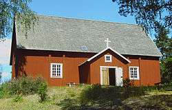
The church of Saint Birgitta is situated in Loppi. It is commonly called the Santa Pirjo, Pirjo being the Finnish version of the name Birgitta. The church is one of the oldest wooden churches in Finland, being about 300 years old.
References
- 1 2 "Area of Finnish Municipalities 1.1.2018" (PDF). National Land Survey of Finland. Retrieved 30 January 2018.
- 1 2 "Ennakkoväkiluku sukupuolen mukaan alueittain, elokuu 2017" (in Finnish). Statistics Finland. Retrieved 18 October 2017.
- ↑ "Population according to language and the number of foreigners and land area km2 by area as of 31 December 2008". Statistics Finland's PX-Web databases. Statistics Finland. Retrieved 29 March 2009.
- ↑ "Population according to age and gender by area as of 31 December 2008". Statistics Finland's PX-Web databases. Statistics Finland. Retrieved 28 April 2009.
- ↑ "List of municipal and parish tax rates in 2011". Tax Administration of Finland. 29 November 2010. Retrieved 13 March 2011.
External links
![]()
- Municipality of Loppi – Official website
- Finnish Sports Aviation Academy (in Finnish)
- Räyskälä Airfield
- Hyrinet – Hyvinkää–Riihimäki area portal (in Finnish)
| Municipalities |  | |
|---|---|---|
| Former municipalities | ||