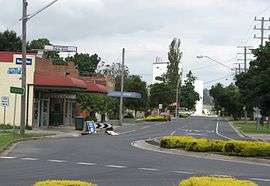
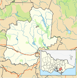
Longwarry, Victoria
| Longwarry Victoria | |||||||||||||||
|---|---|---|---|---|---|---|---|---|---|---|---|---|---|---|---|
 Mackay Street | |||||||||||||||
 Longwarry | |||||||||||||||
| Coordinates | 38°06′0″S 145°46′0″E / 38.10000°S 145.76667°ECoordinates: 38°06′0″S 145°46′0″E / 38.10000°S 145.76667°E | ||||||||||||||
| Population | 2,004 (2016)[1] | ||||||||||||||
| Postcode(s) | 3816 | ||||||||||||||
| Location | |||||||||||||||
| LGA(s) | |||||||||||||||
| County | Buln Buln | ||||||||||||||
| Federal Division(s) | Division of McMillan | ||||||||||||||
| |||||||||||||||
Longwarry is a town in Victoria, Australia, 83 kilometres (52 mi) south-east of Melbourne's Central Business District, located within the Shires of Baw Baw and Cardinia local government areas. Longwarry recorded a population of 2,004 at the 2016 Census. Longwarry has one primary school, Longwarry Primary School.
Longwarry is bypassed by the Princes Freeway.
History
The Post Office opened on 20 June 1881 some time after the railway arrived in 1879. It was renamed Longwarry South (later Ripplebrook) on 1 September 1882 the same day a new office named Longwarry opened near the railway station.[2]
Longwarry railway station provides rail services to Melbourne as well as Bairnsdale.
The town has an Australian Rules football team competing in the Ellinbank & District Football League.[3]
References
- ↑ Australian Bureau of Statistics (27 June 2017). "Gembrook (State Suburb)". 2016 Census QuickStats. Retrieved 20 September 2017.

- ↑ Premier Postal History, Post Office List, retrieved 2008-04-11
- ↑ Full Points Footy, Longwarry, retrieved 2008-07-25
| Wikimedia Commons has media related to Longwarry, Victoria. |