Lone Tree Corners, Illinois
| Lone Tree Corners, Illinois | |
|---|---|
| Former community | |
 | |
 Lone Tree Corners  Lone Tree Corners | |
| Coordinates: 41°11′05″N 89°29′08″W / 41.18472°N 89.48556°WCoordinates: 41°11′05″N 89°29′08″W / 41.18472°N 89.48556°W | |
| Country | United States |
| State | Illinois |
| County | Bureau |
| Elevation | 702 ft (214 m) |
| Time zone | UTC-6 (Central (CST)) |
| • Summer (DST) | UTC-5 (CDT) |
| Area code(s) | 815 & 779 |
| GNIS feature ID | 1719790[1] |
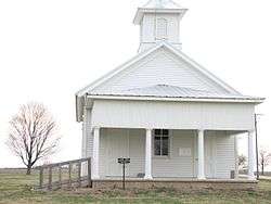
Lone Tree Corners, also known as Lone Tree, is a former community in Bureau County, Illinois, United States, located east of Bradford. The community was established in the 1840s. Its name came from an oak tree in the area; the tree was 100 feet (30 m) tall, and one could reportedly see as far away as Peoria from the top. In the 1920s, the last buildings in the community were demolished, save for the Lone Tree School; the school closed in 1942 but is still standing and is listed on the National Register of Historic Places.[2]
References
- ↑ "Lone Tree Corners". Geographic Names Information System. United States Geological Survey.
- ↑ Ary, Dorothy (January 30, 2004). "National Register of Historic Places Registration Form: Lone Tree School" (PDF). Illinois Historic Preservation Agency. Retrieved June 12, 2016.
Municipalities and communities of Bureau County, Illinois, United States | ||
|---|---|---|
| Cities | ||
| Villages | ||
| Townships | ||
| Unincorporated communities | ||
| Ghost town | ||
| Footnotes | ‡This populated place also has portions in an adjacent county or counties | |
This article is issued from
Wikipedia.
The text is licensed under Creative Commons - Attribution - Sharealike.
Additional terms may apply for the media files.