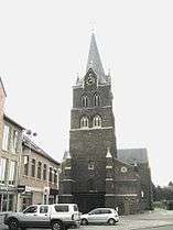
Halen
| Halen | |||
|---|---|---|---|
| Municipality | |||
 | |||
| |||
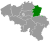
 Halen Location in Belgium
Location of Halen in Limburg 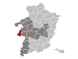 | |||
| Coordinates: 50°56′53″N 05°06′52″E / 50.94806°N 5.11444°ECoordinates: 50°56′53″N 05°06′52″E / 50.94806°N 5.11444°E | |||
| Country | Belgium | ||
| Community | Flemish Community | ||
| Region | Flemish Region | ||
| Province | Limburg | ||
| Arrondissement | Hasselt | ||
| Government | |||
| • Mayor | Erik Van Roelen (CD&V) | ||
| • Governing party/ies | CD&V, SP-a | ||
| Area | |||
| • Total | 36.29 km2 (14.01 sq mi) | ||
| Population (1 January 2017)[1] | |||
| • Total | 9,511 | ||
| • Density | 260/km2 (680/sq mi) | ||
| Postal codes | 3545 | ||
| Area codes | 013 | ||
| Website | www.halen.be | ||


Halen, formerly Haelen, is a municipality located in the Belgian province of Limburg, to the west of Hasselt. On January 1, 2012, Halen had a total population of 9,352. The total area is 36.29 km² which gives a population density of 258 inhabitants per km².
The municipality consists of the following sub-municipalities: Halen proper, Loksbergen, and Zelem.
During the First World War, on August 12, 1914, the Battle of Haelen took place here near the river crossing of the Gete.
References
- ↑ Population per municipality as of 1 January 2017 (XLS; 397 KB)
External links


- (in Dutch) Official website
Places adjacent to Halen | ||||||||||
|---|---|---|---|---|---|---|---|---|---|---|
| ||||||||||
This article is issued from
Wikipedia.
The text is licensed under Creative Commons - Attribution - Sharealike.
Additional terms may apply for the media files.