Diepenbeek
| Diepenbeek | |||
|---|---|---|---|
| Municipality | |||
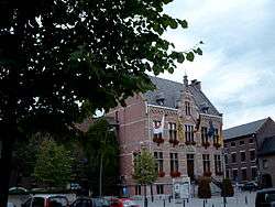 Diepenbeek town hall | |||
| |||
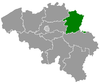
 Diepenbeek Location in Belgium
Location of Diepenbeek in Limburg 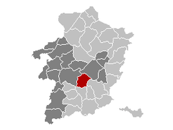 | |||
| Coordinates: 50°54′N 05°24′E / 50.900°N 5.400°ECoordinates: 50°54′N 05°24′E / 50.900°N 5.400°E | |||
| Country | Belgium | ||
| Community | Flemish Community | ||
| Region | Flemish Region | ||
| Province | Limburg | ||
| Arrondissement | Hasselt | ||
| Government | |||
| • Mayor | Patrick Hermans | ||
| • Governing party/ies | Puur, Open VLD, N-VA, CD&V | ||
| Area | |||
| • Total | 41.19 km2 (15.90 sq mi) | ||
| Population (1 January 2017)[1] | |||
| • Total | 19,086 | ||
| • Density | 460/km2 (1,200/sq mi) | ||
| Postal codes | 3590 | ||
| Area codes | 011 | ||
| Website | www.diepenbeek.be | ||


Diepenbeek (Dutch pronunciation: [ˈdipə(m)beːk]; Limburgish: Diepenbik) is a municipality located in the Belgian province of Limburg near Hasselt. On January 1, 2012, Diepenbeek had a total population of 18,337. Its total area is 41.19 km² which gives a population density of 430 inhabitants per km².
The municipality includes the communities and hamlets of Bijenberg, het Crijt, Dorpheide, Keizel, Lutselus, Pampert, Piannesberg, Reitje, Rooierheide, Rozendaal, and Zwartveld.
It is home to Hasselt University, slowly expanding towards Hasselt itself. The Limburg Science Park is located on the university campus.
References
- ↑ Population per municipality as of 1 January 2017 (XLS; 397 KB)
External links

- Official website - Only available in Dutch
This article is issued from
Wikipedia.
The text is licensed under Creative Commons - Attribution - Sharealike.
Additional terms may apply for the media files.