Logan River (Utah-Idaho)
| Logan River | |
 Logan River in the Wasatch-Cache National Forest | |
| Country | United States |
|---|---|
| States | Utah, Idaho |
| Counties | Cache County, Utah, Franklin County, Idaho |
| Source | |
| - location | east of Preston, Franklin County, Idaho |
| - elevation | 8,096 ft (2,468 m) [1] |
| - coordinates | 42°02′07″N 111°35′58″W / 42.03528°N 111.59944°W [2] |
| Mouth | Little Bear River |
| - location | west of Logan, Cache County, Utah |
| - elevation | 4,413 ft (1,345 m) [2] |
| - coordinates | 41°44′29″N 111°57′17″W / 41.74139°N 111.95472°WCoordinates: 41°44′29″N 111°57′17″W / 41.74139°N 111.95472°W [2] |
| Length | 54 mi (87 km) [3] |
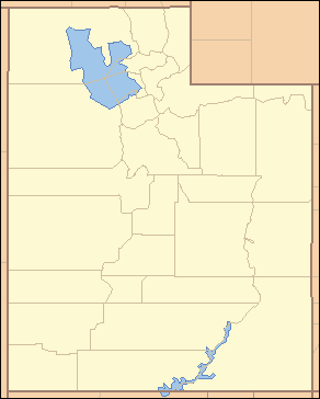 Location of the mouth of the Logan River in Utah | |
The Logan River is a 53.7-mile-long (86.4 km)[3] tributary of the Little Bear River in Utah, the United States. It is currently being studied to determine whether it is suitable for National Wild and Scenic Rivers designation.[4]
Course
The Logan River rises in the Bear River Mountains in Idaho and flows south, then southwest through Logan Canyon and the Wasatch-Cache National Forest to the city of Logan, Utah, in the Cache Valley. In this valley it joins the Little Bear River a few miles west of Logan and about 5 miles (8 km) south of where the Little Bear River joins the Bear River.
The river is dammed at 1st, 2nd, and 3rd dams at the mouth of Logan Canyon.
See also
References
- ↑ Source elevation derived from Google Earth search using GNIS source coordinates.
- 1 2 3 "Logan River". Geographic Names Information System. United States Geological Survey. December 31, 1979. Retrieved July 23, 2013.
- 1 2 "National Hydrography Dataset". United States Geological Survey. Retrieved July 23, 2013.
- ↑ Wild and Scenic Rivers - USDA Forest Service Intermountain Region
External links
![]()
This article is issued from
Wikipedia.
The text is licensed under Creative Commons - Attribution - Sharealike.
Additional terms may apply for the media files.