Locust Grove Historic District
|
Locust Grove Historic District | |
| Location | Centered along GA 42/US 23 between Hi-Hope Dr. & Grove Rd., Locust Grove, Georgia |
|---|---|
| Coordinates | 33°20′51″N 84°06′35″W / 33.34750°N 84.10972°WCoordinates: 33°20′51″N 84°06′35″W / 33.34750°N 84.10972°W |
| Area | 310 acres (130 ha) |
| Architectural style | Late 19th and Early 20th Century American Movements |
| NRHP reference # | 16000451[1] |
| Added to NRHP | February 18, 2016 |
The Locust Grove Historic District, in McDonough, Georgia, is a 310 acres (130 ha) historic district which was listed on the National Register of Historic Places in 2016.[1]
It is centered on GA 42/US 23 between Hi-Hope Dr. & Grove Rd. The district includes 157 contributing buildings, a contributing structure, and two contributing sites, as well as 76 non-contributing buildings.[2]
It includes:
| Resource | Photo | Dates | Location | Notes |
|---|---|---|---|---|
| Locust Grove Institute Academic Building now City Hall |
 |
3644 State Route 42//US 23 33°21′07″N 84°06′50″W / 33.35194°N 84.11389°W |
Separately listed on the National Register | |
| House at 3590 Highway 42 | 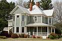 |
3590 Highway 42 33°21′13″N 84°06′51″W / 33.353745°N 84.114298°W |
Queen Anne-style house, serving as Locust Grove Veterinary Clinic | |
| House at 377 N. Jackson St. | .jpg) |
377 N. Jackson St. 33°21′18″N 84°06′51″W / 33.355047°N 84.114186°W |
Queen Anne-style | |
| House at 3550 GA-42 | .jpg) |
3550 GA-42 33°21′16″N 84°06′54″W / 33.354490°N 84.115049°W |
||
| House at 3570 GA-42 | .jpg) |
3570 GA-42 33°21′15″N 84°06′52″W / 33.354068°N 84.114550°W |
||
| House at 339 N. Jackson St. | .jpg) |
339 N. Jackson St. 33°21′21″N 84°06′54″W / 33.355928°N 84.114936°W |
||
References
- 1 2 "Locust Grove Historic District". National Park Service.
- ↑ Denise P. Messick (May 2016). "National Register of Historic Places Registration: Locust Grove Historic District" (PDF). National Park Service. Retrieved April 2, 2018. With 39 photos from 2014 and map.
External links

| Topics | |
|---|---|
| Lists by states |
|
| Lists by insular areas | |
| Lists by associated states | |
| Other areas | |
| |
This article is issued from
Wikipedia.
The text is licensed under Creative Commons - Attribution - Sharealike.
Additional terms may apply for the media files.