Loch of Butterstone
| Loch of Butterstone | |
|---|---|
 Loch of Butterstone on a winters day. | |
 Loch of Butterstone | |
| Location | Dunkeld, Perth and Kinross |
| Coordinates | 56°35′14″N 3°32′01″W / 56.587100°N 3.533700°WCoordinates: 56°35′14″N 3°32′01″W / 56.587100°N 3.533700°W |
| Type | freshwater loch |
| River sources | Lunan Burn |
| Surface area | 43.5 ha (107 acres)[1] |
| Average depth | 11.25 ft (3.43 m)[2] |
| Max. depth | 25 ft (7.6 m)[2] |
| Water volume | 53,283,000 cu ft (1,508,800 m3)[2] |
| Shore length1 | 2.8 km (1.7 mi) [1] |
| Surface elevation | 97 m (318 ft) |
| Max. temperature | 63 °F (17 °C) |
| Min. temperature | 53 °F (12 °C) |
| Settlements | Dunkeld |
| 1 Shore length is not a well-defined measure. | |
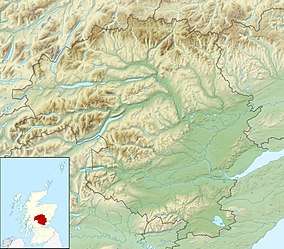
Loch of Butterstone is a small freshwater loch, almost circular in design,[2] located within the nature reserve of the Cardney Estate, near Dunkeld in Perth and Kinross.[3] It is one of a group of three lochs, which include Loch of the Lowes and Loch of Craiglush, which are located next to each other in southeast to northwest orientation. Loch of Butterstone is located at the top of the group at the northwest end, with Loch of the Lowes being at the southwest and Loch of Craiglush located north of Loch of the Lowes. The three lochs are form a chain of lochs known as the Lunan Lochs.[4]
Settlements
Dunkeld is the largest settlement, which is located southeast from the loch. The A923 main road passes to the north of the three lochs, which runs from Dundee to Dunkeld.
Geography
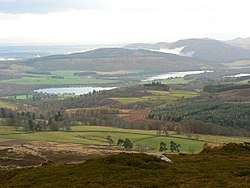
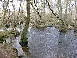
The loch lies at the head of the valley of the Lunan Burn, which flows east and southeast to join the River Isla near Coupar Angus.[5] The primary feature of Loch of Butterstone, is the clearness of the water, which has been described as gin clear. This startling clearness is particularly noticeable in Scotland, when most lochs are peat lochs, and are therefore peaty in colour.
The three lochs are located in shallow valley, with a northeast orientation, looking from the Dunkeld side. The most prominent feature, is Newtyle Hill at 317 metres, which is closest to Loch of Lowes. At the other side of the valley is a number of shallow hills, including Crieff Hill, at the base of the three lochs, on the northeast orientation, rising to Craig More. The surrounding area is heavily wooded. On the west slope, looking from Dunkeld, is Drumbuie Wood.
Loch of Butterstone is a well known flyfishing loch.
References
- 1 2 "Loch of Butterstone". British Lakes. Retrieved 12 January 2018.
- 1 2 3 4 John, Murray; Lawrence, Pullar (1910). Bathymetrical Survey of the Fresh-Water Lochs of Scotland, 1897-1909 Lochs of the Tay Basin Volume II - Loch of Butterstone. National Library of Scotland: National Challenger Officer. p. 102.
|access-date=requires|url=(help) - ↑ "Loch of Butterstone". Ordnance Survey. OS Maps. Retrieved 12 January 2018.
- ↑ Lunan Lochs Project Natural Care Scheme (PDF), Scottish Natural Heritage
- ↑ "Butterstone, Loch of". The Editors of The Gazetteer for Scotland. School of GeoSciences, University of Edinburgh and The Royal Scottish Geographical Society. Retrieved 12 January 2018.