Loch Iubhair
| Loch Iubhair | |
|---|---|
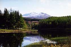 Loch Iubhair Glen Dochart The mountain in the distance is Sgiath Chuil. | |
 Loch Iubhair | |
| Coordinates | 56°24′30″N 4°33′11″W / 56.4083°N 4.553°WCoordinates: 56°24′30″N 4°33′11″W / 56.4083°N 4.553°W |
| Type | freshwater loch |
| Primary outflows | River Dochart |
| Max. length | 2.09215 km (1.30000 mi)[1] |
| Max. width | 0.482 km (0.300 mi)[1] |
| Surface area | 60.7 ha (150 acres)[2] |
| Average depth | 25 ft (7.6 m)[1] |
| Max. depth | 65 ft (20 m)[1] |
| Shore length1 | 7.4 km (4.6 mi) [2] |
| Surface elevation | 152 m (499 ft)[2] |
| 1 Shore length is not a well-defined measure. | |
Loch Iubhair is a freshwater loch, located in Glen Dochart, and 4 miles east of the village of Crianlarich. Loch Dochart is located immediately to the south east, and the outflow of Loch Dochart, as the River Dochart flows into Loch Iubhair.[3][1][2]
References
- 1 2 3 4 5 John, Murray; Lawrence, Pullar (1910). Bathymetrical Survey of the Fresh-Water Lochs of Scotland, 1897-1909 Lochs of the Tay Basin Volume II - Loch Iubhair. National Library of Scotland: National Challenger Officer. p. 75. Retrieved 24 July 2018.

- 1 2 3 4 "Loch Iubhair". British Lakes. Retrieved 24 July 2018.
- ↑ "Iubhair, Loch". The Gazetteer for Scotland. School of GeoSciences, University of Edinburgh and The Royal Scottish Geographical Society. Retrieved 24 July 2018.
This article is issued from
Wikipedia.
The text is licensed under Creative Commons - Attribution - Sharealike.
Additional terms may apply for the media files.