Loch Dochart
| Loch Dochart | |
|---|---|
 | |
| Location | Stirling, Scotland |
| Coordinates | 56°23′47″N 4°35′3″W / 56.39639°N 4.58417°WCoordinates: 56°23′47″N 4°35′3″W / 56.39639°N 4.58417°W |
| Type | freshwater loch |
| Primary inflows | River Fillan |
| Primary outflows | River Dochart |
| Basin countries | Scotland |
| Max. length | 0.66 mi (1.06 km)[1] |
| Max. width | 0.16 mi (0.26 km)[1] |
| Surface area | 46 acres (19 ha)[1] |
| Average depth | 5 ft (1.5 m)[1] |
| Max. depth | 11 ft (3.4 m)[1] |
| Water volume | 10,032,000 cu ft (284,100 m3)[1] |
| Surface elevation | 513 ft (156 m)[1] |
| Islands | 1 islet |
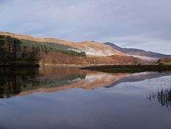
Loch Dochart is a small freshwater loch on the Lochdochart Estate in Stirling, Scottish Highlands. It lies approximately 1.7 km (1.1 mi) to the east of the town of Crianlarich at the foot of Ben More.[1] There is a small wooded island in the middle of the loch on which stands the ruins of a castle originally built by Sir Duncan Campbell between 1583 and 1631.[2]
The loch was surveyed[1] on 11 May 1902 by T.N. Johnston and James Parsons and later charted [3] as part of Sir John Murray's The Bathymetrical Survey of Fresh-Water Lochs of Scotland 1897-1909.[4]
References
- 1 2 3 4 5 6 7 8 9 "Bathymetrical Survey of the Fresh-Water Lochs of Scotland, 1897-1909, Lochs of the Tay Basin". National Library of Scotland. National Library of Scotland. Retrieved 2014-08-20.
- ↑ "Loch Dochart Castle". www.canmore.rcahms.gov.uk. Canmore. 29 June 1962. Retrieved 2014-08-20. .
- ↑ "Lochs Dochart & Iubhair (Vol. 3, Plate 20) - Bathymetrical Survey, 1897-1909 - National Library of Scotland". www.nls.uk. Retrieved 2014-08-20.
- ↑ Murray, John; Pullar, Laurence (1910). Bathymetrical Survey of Fresh-Water Lochs of Scotland during the years 1897 to 1909: report on scientific results. Edinburgh.
| Wikimedia Commons has media related to Lochs of Stirling (council area). |
This article is issued from
Wikipedia.
The text is licensed under Creative Commons - Attribution - Sharealike.
Additional terms may apply for the media files.