Loch Howie
| Loch Howie | |
|---|---|
 | |
| Location | Dumfries and Galloway, Scotland |
| Coordinates | 55°07′41″N 4°02′45″W / 55.128100°N 4.045800°WCoordinates: 55°07′41″N 4°02′45″W / 55.128100°N 4.045800°W[1] |
| Type | freshwater loch |
| Primary outflows | Mid Burn[2] |
| Basin countries | Scotland |
| Max. length | 0.75 mi (1.21 km)[2] |
| Max. width | 0.125 mi (0.201 km)[2] |
| Surface area | 17.7 ha (44 acres)[1] |
| Average depth | 16 ft (4.9 m)[2] |
| Max. depth | 31 ft (9.4 m)[2] |
| Water volume | 31,000,000 cu ft (880,000 m3)[2] |
| Shore length1 | 2.6 km (1.6 mi)[1] |
| Surface elevation | 233 m (764 ft)[1] |
| Islands | 0[1] |
| 1 Shore length is not a well-defined measure. | |
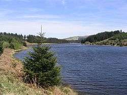
Loch Howie is a small, narrow, upland freshwater loch on the north side of Blackcraig Hill, approximately 18 miles (29 km) west of Dumfries, Scotland. The loch trends from south-west to north-east and is 0.75 mi (1.21 km) long by approximately 0.25 mi (0.40 km) at its widest point. It has an average depth of 16 ft (4.9 m) and is 39 ft (12 m) at its deepest. The loch was surveyed[2] on 23 July 1903 by James Murray[3] as part of Sir John Murray's Bathymetrical Survey of Fresh-Water Lochs of Scotland 1897-1909.
The loch is popular for fishing and is populated with perch, pike and roach.[4]
References
- 1 2 3 4 5 "Loch Howie". British lakes. British Lakes. Retrieved 2 July 2016.
- 1 2 3 4 5 6 7 "Bathymetrical Survey of the Fresh-Water Lochs of Scotland, 1897-1909, Lochs of the Nith Basin". National Library of Scotland. Retrieved 2 July 2016.
- ↑ "Lochs Howie and Skae; Lochrutton Loch; Lochaber Loch; Loch Kindar; Loch Fleet (Vol. 5, Plate 46)". National Library of Scotland. Retrieved 2 July 2016.
- ↑ "Craigdarroch Fishing Club". Moniaive. Retrieved 2016-07-02.
This article is issued from
Wikipedia.
The text is licensed under Creative Commons - Attribution - Sharealike.
Additional terms may apply for the media files.