Llanfyrnach
| Llanfyrnach | |
|---|---|
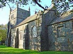 Parish church of St Brynach, Llanfyrnach | |
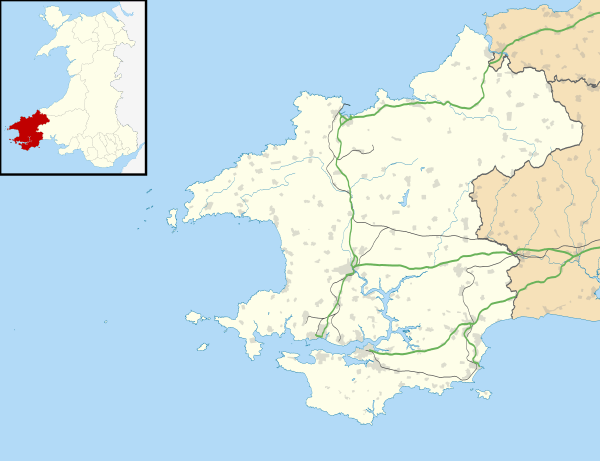 Llanfyrnach Llanfyrnach shown within Pembrokeshire | |
| OS grid reference | SN2195331195 |
| Community | |
| Principal area | |
| Ceremonial county | |
| Country | Wales |
| Sovereign state | United Kingdom |
| Postcode district | SA35 |
| Dialling code | 01239 |
| Police | Dyfed-Powys |
| Fire | Mid and West Wales |
| Ambulance | Welsh |
| EU Parliament | Wales |
| UK Parliament | |
Llanfyrnach is a village, community and parish in Pembrokeshire, Wales. The village is in the electoral ward of Crymych. The village of Crymych and the hamlets of Hermon, Glandwr and Pentre Galar, are in Llanfyrnach parish. Llanfyrnach means the church of St Brynach.
Llanfyrnach village is in a remote upland area on the headwaters of the River Tâf, about 11 miles (18 km) from Cardigan.
History
The parish of Llanfyrnach was in the ancient Cantref of Cemais.[1]
There is a small Norman motte close to the church. Much of the parish was unenclosed moorland until the start of the 19th century. Population doubled as numerous small farms were established following enclosure from the 16th century onwards.[2]
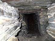
There was an important lead mine on the north side of the village until the end of the 19th century. Mining occurred on a small scale for the sake of the low but significant concentration of silver in the ores, perhaps from as early as the 16th century. As a result of high demand for lead in the Victorian era, the mine was greatly extended in the 1840s, and had reached 520 m below the surface by the time of its closure in 1890.[3]
The Whitland & Taf Vale Railway reached the village in 1873,[4] and the village became a transport depot for the surrounding hill country; lead and agricultural produce were shipped out, and heavy supplies, notably lime, were brought in. Although the railway closed in 1963, the village is still a transport hub with Mansel Davies, the road haulage company, based in the village.[5]
The Celtic Blue Rock festival was held at Trefawr Farm in the village,[6] but lost its licence in 2010.[7]
St Brynach's Church
The present church is mid-Victorian, but there has been a Christian community in the village since at least as far back as the 6th century when St Brynach is believed to have come to the area. The parish includes a number of other settlements, particularly the village of Crymych and the hamlets of Glandwr and Pentre Galar.[8][9] In 1872 the parish covered 6,328 acres (2,561 ha).[10]
Demographics
The village remains small, with much of the workforce employed in transportation. The population of the parish was 542 (1801), 933 (1851), 954 (1901), 844 (1951) and 837 (1981).[2] The area remains largely Welsh-speaking; the proportion of Welsh speakers was 100% in 1891, 97% in 1931 and 82% in 1971.
Notable people
The Welsh language poet Thomas Evan Nicholas (Niclas y Glais) was born in Llanfyrnach in 1878.
See also
- Llanfyrnach Rural District, historic local government area abolished in 1934
References
- ↑ "GENUKI: Llanfyrnach". Retrieved 2 July 2014.
- 1 2 "Llanfyrnach CP/AP through time". Retrieved 2 July 2014.
- ↑ Claughton, Peter (1999). Llanfyrnach Mine (with further references). Exeter University. Retrieved 2 July 2014.
- ↑ Jones, R Emrys (1979). Rheilffyrdd Cymru. Argraffdy Arfon. p. 54. ISBN 0-85365-922-2.
- ↑ "Top 100 companies in south west Wales". South Wales Evening Post. 24 September 2014. Retrieved 3 May 2015.
- ↑ "BBC News". Retrieved 22 April 2015.
- ↑ "Celtic Blue Rock festival loses licence over safety fears". WalesOnline. 20 May 2010. Retrieved 3 May 2015.
- ↑ "Llanfyrnach Church". Retrieved 2 July 2014.
- ↑ "GENUKI: Llanfyrnach parish map". Retrieved 22 April 2015.
- ↑ Wilson, J.M. (1872). Imperial Gazetteer of England and Wales 1870-72. Retrieved 2 July 2014.
| Wikimedia Commons has media related to Llanfyrnach. |
External links
| Preceding station | Historical railways | Following station | ||
|---|---|---|---|---|
| Rhydowen | Great Western Railway Whitland & Cardigan Railway |
Glogue | ||