Little Venice, London
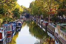
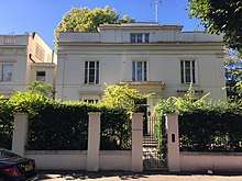
Little Venice is a neighbourhood in London centred on an area of decorative houseboats and a partly tree-lined, three-way junction of canals. Many of its buildings are Regency white painted stucco terraced town houses and taller blocks (mansions) in the same style. The junction, a small fraction larger than usual along the canals, is that of the Paddington Arm of the Grand Union Canal and the Regent's Canal, and is also known as Browning's Pool or Little Venice Lagoon. To the south is the largely commercial Paddington Basin and Hyde Park.
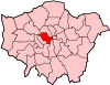
Little Venice is also a ward frequently named when warding is done every 8-12 years by the City of Westminster for elections (for councillor representation).[1][2] The ward had 11,040 residents according to the local authority in 2015.[2] A main street wholly in the ward is Warwick Avenue. The area rises to the north and includes the tube station of the same name.
Name
%2C_p201.jpg)
Little Venice is a comparatively recent name for parts of Paddington and Maida Vale in the City of Westminster, which had been referred to as London's "Venice" for a century before "Little" was added. The name was in frequent use by the latter half of the 20th century.
The origin of the name is sometimes attributed to the poet Robert Browning who lived at Beauchamp Lodge, 19 Warwick Crescent, in 1862–87.[4] This was disputed by Lord Kinross in 1966[5] who asserted that Lord Byron (1788–1824) first humorously compared the locale to Venice. The name "little Venice" was later formally applied to an electoral ward of the City of Westminster.[6]
Extent
.jpg)
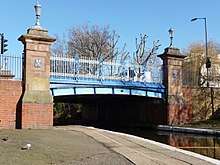
The boundaries of the neighbourhood of Little Venice are unclear, however the majority of its buildings have a Regency style architectural style of white painted stucco facades. This architectural style and the proximity to the canals defines the area. The name Little Venice is now being used for a wider area than previously to include new developments surrounding Paddington Basin (Merchant Square/Paddington Central). Although the Paddington Basin development is sometimes included as a part of Little Venice, the modern architectural style of Paddington Basin sets it apart from the rest of the area. The name Maida Vale[7] is likewise fairly recent. Most of the area was part of Paddington, a parish of early medieval creation. Land north of Browning's Pool was later referred to as Kilburn Fields, or as to its then developed minority part of Kilburn, which by the mid-nineteenth century formed four ecclesiastical chapelries, the local two of which (one of which is relevant) had lain in Hampstead, but Kilburn had for centuries been a major hamlet.[8]
It is generally considered the area is roughly bounded by Delamere Terrace, Warwick Crescent, Howley Place and Maida Avenue at the south, Maida Vale Road at the east, the Lord Hill Rd / Formosa St footbridge at the west and Sutherland Avenue at its north. This is the area surrounding the Little Venice Lagoon and its canals containing the Regency style white stucco buildings.
Facilities
Little Venice is one of London's prime residential areas and contains restaurants, shops, theatres and pubs. Canalside venues include Canal Cafe Theatre, the Puppet Theatre Barge, the Waterside Café, the Summerhouse Restaurant and Cafe La Ville.
In the north where the area blends into Maida Vale are three Grade II (initial category) listed pubs for their historic interiors and façades, The Warwick Castle, The Warrington, and The Prince Alfred.[9]
The Inland Waterways Association has hosted a Canalway Cavalcade locally since 1983.[10]
Notable buildings
- The Colonnade Hotel on Warrington Crescent, originally a pair of houses dating from 1863, is particularly ornate, with mouldings and a continuous first-floor balustrade. [11][12]. The building has historical connection with both Alan Turing and Sigmund Freud and there are blue plaques on the exterior attesting to the same.
- Pondfield House on Clifton Gardens was formerly a Metropolitan Police section house until the 1980s.
Notable residents
- Katherine Mansfield stayed as a music student at Beauchamp Lodge (no. 2 Warwick Crescent) 1908-9.
- Sigmund Freud lived briefly in what is now the Colonnade Hotel, situate where Warrington Crescent meets Clifton Road and Warwick Avenue.
- Alan Turing was born in 1912 in a maternity home in Warrington Crescent; the building later became what is now called the Colonnade Hotel (see above).
Transport
A regular waterbus service operates from Little Venice eastward around Regent's Park, calling at London Zoo and continuing towards Camden Town. Little Venice is served by one tube station, Warwick Avenue on the Bakerloo line, and by the No. 6, 46, 187 and 414 bus services.
References
- ↑ "Little Venice - MapIt". Mapit.mysociety.org. Retrieved 22 January 2018.
- 1 2 "Little Venice : Ward Profile" (PDF). Transact.westminster.gov.uk. Retrieved 22 January 2018.
- ↑ Metropolitan Improvements, 1828, p. 201.
- ↑ "The history of the place name known as 'Little Venice'". London Canals, U.K. Retrieved 12 February 2018.
- ↑ "Letter to Editor". The Daily Telegraph, 1966. Retrieved 22 January 2018.
- ↑ "Little Venice Ward Profile, 2018" (PDF). City of Westminster. 2018. Retrieved 12 February 2018.
- ↑ "Paddington: Maida Vale - British History Online". British-history.ac.uk. Retrieved 22 January 2018.
- ↑ T F T Baker, Diane K Bolton and Patricia E C Croot, 'Hampstead: Kilburn, Edgware Road, and Cricklewood', in A History of the County of Middlesex: Volume 9, Hampstead, Paddington, ed. C R Elrington (London, 1989), pp. 47-51. British History Online http://www.british-history.ac.uk/vch/middx/vol9/pp47-51 [accessed 27 January 2018].
- ↑ Historic England. "Details from listed building database (1066328)". National Heritage List for England.
- ↑ "Canalway Cavalcade: 2nd–4th May 2015". Waterways.org.uk, Accessed 5 November 2014
- ↑ "Paddington: Maida Vale". British History Online: A History of the County of Middlesex: Volume 9, Hampstead, Paddington. Originally published by Victoria County History, London, 1989.
- ↑ "The Colonnade Hotel in Little Venice - Official Website". The Colonnade Hotel. Retrieved 2018-06-13.
External links
![]()