Little Neshaminy Creek
| Little Neshaminy Creek | |
|---|---|
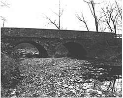 Stone bridge that once carried Pennsylvania Route 152 over the Little Neshaminy Creek | |
 Little Neshaminy Creek | |
| Country | United States |
| State | Pennsylvania |
| County | Montgomery, Bucks |
| Township |
Horsham Montgomery Warrington Warminster Warwick Northampton |
| Physical characteristics | |
| Main source |
450 feet (140 m) 40°13′48″N 75°14′49″W / 40.23000°N 75.24694°W |
| River mouth |
125 feet (38 m) 40°15′21″N 75°1′59″W / 40.25583°N 75.03306°WCoordinates: 40°15′21″N 75°1′59″W / 40.25583°N 75.03306°W |
| Length | 15.5 miles (24.9 km) |
| Basin features | |
| Progression | Little Neshaminy Creek → Neshaminy Creek → Delaware River → Delaware Bay |
| River system | Delaware River |
| Basin size | 43 square miles (110 km2) |
| Landmarks |
Windlestrae Park Nikesite Park Lower Nike Park Bradford Reservoir Kemper Park Barness Park |
| Tributaries |
|
| Waterbodies | Bradford Reservoir |
| Slope | 20.97 feet per mile (3.972 m/km) |
Little Neshaminy Creek is a tributary of the Neshaminy Creek, part of the Delaware River Watershed rising near the intersection of U.S. Route 202 and Pennsylvania Route 309 near Montgomeryville, Pennsylvania and meets its confluence with Neshaminy Creek at the Neshaminy's 24.10 River mile.
History
There were a number of mills erected on the Little Neshaminy including the Old Hartsville Mill and the Upper and Lower Mearns' Mills. In 1942 there were ten bridges across the creek.[1]
Statistics
The watershed of the Little Neshaminy Creek is 43 square miles (110 km2), passing through surburban residential and commercial areas, as well as four public parks in Montgomery County, and Bucks County. The Geographic Name Information System I.D. is 1179624,[2] U.S. Department of the Interior Geological Survey I.D. is 02638.[3]
Course
Rising in Montgomery Township the Little Neshaminy Creek runs generally east for about 3.5 miles (5.6 km) passing through Windlestrae Park on the way where it meets unnamed tributary from the left, and another unnamed tributary from the right to the east of the park, then it runs southeast for 1.5 miles (2.4 km) touching Nike Park, then the Bradford Reservoir Recreation Area and dam where it meets another tributary from the right in the reservoir and meets Park Creek from the right below the reservoir at the Little Neshaminy's 6.32 river mile. Finally, it runs generally east for about 6.25 miles (10.06 km) picking up one tributary from the left and five on the right where it meets its confluence at the Neshaminy Creek's 24.10 River mile.[4]
Geology
The Little Neshaminy lies entirely within the Lockatong geologic formation, consisting of argillite, shale, limestone, and calcareous shale.[5]
Named tributaries
Municipalities
Crossings and bridges
| Crossing | NBI Number | Length | Lanes | Spans | Material/Design | Built | Reconstructed | Latitude | Longitude |
|---|---|---|---|---|---|---|---|---|---|
| Pennsylvania Route 309 (Bethlehem Pike) | - | - | - | - | - | - | - | - | - |
| Pennsylvania Route 463 (Horsham Road) | - | - | - | - | - | - | - | - | - |
| Stump Road | 27883 | 9 metres (30 ft) | 2 | 2 | Stringer/multi-beam or girder, concrete continuous | 1916 | - | - | - |
| Springhouse Court | - | _ | - | - | - | - | - | - | - |
| Kenas Road (SR 2014) | 27606 | 11 metres (36 ft) | 2 | 1 | slab design concrete | 1959 | - | - | - |
| Pennsylvania Route 152 (Limekiln Pike) | 27322 | 13 metres (43 ft) | 2 | 2 | Arch Deck, stone masonry | - | 2012 | - | |
| County Line Road | 7268 | 16 metres (52 ft) | 3 | 1 | Box Beam or Girder - multiple, prestressed concrete | 1985 | - | 40°14'10"N | 75°10'44"W |
| Kansas Road | 7531 | 11 metres (36 ft) | 2 | 1 | Box Beam or Girder - multiple, prestressed concrete | 1979 | - | 40°13'27"N | 75°8'42"W |
| Pennsylvania Route 611 (Easton Road) | 7059 | 32 metres (105 ft) | 5 | 2 | Box Beam or Girder - multiple, prestressed concrete | 1963 | - | 40°13'31"N | 75°8'25"W |
| Paul Valley Road | 53690 | 24.4 metres (80 ft) | - | - | Concrete Box Beam or girders - single or spread, concrete cast-in-place decking | 2008 | - | 40°13'29"N | 75°8'4"W |
| Pennsylvania Route 132 (West Street Road) | 6904 | 52 metres (171 ft) | 2 | 3 | Stringer multi-beam or girder, prestressed concrete continuous | 1960 | 1995 | - | - |
| Valley Road | 7930 | 40 metres (130 ft) | 2 | 3 | Box Beam or Girder, prestressed concrete | 1965 | - | 40°13'44"N | 75°7'12"W |
| West Bristol Road | 40736 | 91 metres (299 ft) | 2 | 3 | Stringer/Multi-beam or Girder, steel continuous | 1999 | - | 40°13'57"N | 75°6'7"W |
| Old York Road | 7649 | 25 metres (82 ft) | 2 | 1 | Stringer/Multi-beam or Girder, steel | 1930 | 2000 | 40°14'4"N | 75°5'28"W |
| Pennsylvania Route 263 (York Road) | - | - | - | - | - | - | - | - | |
| Almshouse Road | 7333 | 43 metres (141 ft) | 2 | 2 | Box Beam or Girder, prestressed concrete | 1963 | 2011 | 40°14'21"N | 75°3'40"W |
| Sacketts Ford Road | 7356 | 29 metres (95 ft) | 2 | 1 | Stringer/Multi-beam or Girder, steel | 1973 | - | 40°15'20"N | 75°2'2"W |
See also
- List of rivers of Pennsylvania
- List of rivers of the United States
- List of Delaware River tributaries
|


References
- ↑ MacReynolds, George, Place Names in Bucks County, Pennsylvania, Doylestown, Bucks County Historical Society, Doylestown, PA, 1942, P229.
- ↑ http://geonames.usgs.gov/apex/f?p=gnispq:3:::NO::P3_FID:1179624
- ↑ http://www.lycoming.edu/cwi/pdfs/paGazetterOfStreams.pdf, page 87
- ↑ https://www.google.com/maps/place/Little+Neshaminy+Creek/@40.2392382,-75.1308432,13z/data=!3m1!4b1!4m5!3m4!1s0x89c6af314140427f:0x22a86b9feb26f5ff!8m2!3d40.2392435!4d-75.0958238
- ↑ "Pennsylvania Geological Survey". PaGEODE. Pennsylvania Department of Conservation and Natural Resources. Retrieved 19 November 2017.