Little Kyll
| Little Kyll | |
|---|---|
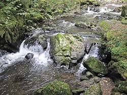 Waterfall near the Wolfsschlucht gorge | |
| Location | Vulkaneifel, Bernkastel-Wittlich; Rhineland-Palatinate; Germany |
| Reference no. | DE: 26784 |
| Physical characteristics | |
| Main source |
On the heights of the Neroth woods in the county of Vulkaneifel ca. 584 m above sea level (NHN) 50°12′37″N 6°45′36″E / 50.210182°N 6.75988°ECoordinates: 50°12′37″N 6°45′36″E / 50.210182°N 6.75988°E |
| River mouth |
Discharges south of Manderscheid into the Lieser ca. 246 m above sea level (NHN) 50°03′48″N 6°48′51″E / 50.06322°N 6.814206°E |
| Length | 23.879 km [1] |
| Basin features | |
| Progression | Lieser→ Moselle→ Rhine→ North Sea |
| Basin size | 83.545 km² [1] |
| Landmarks | Villages: Neroth, Oberstadtfeld, Niederstadtfeld, Schutz |
| Tributaries | |
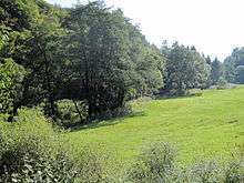 Valley of the Kleine Kyll south of its confluence with the Meerbach | |
The Little Kyll[2][3] German: Kleine Kyll, pronounced: "kill") is a 23.9-kilometre-long orographically right-hand tributary of the Lieser.
Geography
Course
The Little Kyll rises two kilometre northeast of Neroth on the heights of the Neroth woods in the county of Vulkaneifel in the German state of Rhineland-Palatinate. It flows in a southerly direction through the municipalities of Neroth, Oberstadtfeld, Niederstadtfeld and Schutz and empties into the Lieser south of Manderscheid, Bernkastel-Wittlich.
Tributaries
The tributaries of the Little Kyll include the following (in a downstream direction): [1]
| Name | GKZ | Length (km) | Direction | Confluene after km | Location |
|---|---|---|---|---|---|
| Enzenbach | 2678412 | 2.6 | right | 21.3 | Neroth |
| Kreuzbach | 26784132 | 0.8 | right | 20.5 | |
| Dehmbach | 1.0 | right | 19.7 | ||
| Bach vom Birkenberg (Winkelbach) | 2678414 | 1.5 | left | 18.2 | Oberstadtfeld |
| Risselbach | 1.3 | left | 16.6 | Niederstadtfeld | |
| Kälberbach | 2678416 | 3.9 | right | 16.2 | Niederstadtfeld |
| Kerlbach | 1.0 | left | 15.2 | Niederstadtfeld | |
| Walmerbach | 267842 | 7.2 | right | 11.9 | Schutz |
| Speicherbach | 267844 | 3.5 | right | 10.0 | |
| Meerbach | 267846 | 4.2 | right | 6.3 | Meerfeld |
| Ellbach | 26784712 | 2.0 | right | 4.7 | |
| Dombach | 1.0 | left | 2.6 | Manderscheid | |
| Horngraben | 2678472 | 2.5 | right | 1.9 | |
| Fischbach | 267848 | 6.1 | right | 0.8 |
Recreation
In the area between Oberstadtfeld and Bleckhausener Mühle/Meerfeld the Kosmos Cycleway (Kosmosradweg) runs parallel to the Kleine Kyll.
At the confluence with the Horngraben, south of Manderscheid is the gorge of Wolfsschlucht[4] as well as a waterfall.
References
- 1 2 3 Geoexplorer of the Rhineland-Palatinate Water Authority (Wasserwirtschaftsverwaltung Rheinland-Pfalz)
- ↑ K. Baedeker (1870), The Rhine and Northern Germany: Handbook for Travellers, Coblenz: Baedeker, p. 116
- ↑ Charles B. MacDonald, United States Army in WWII - Europe - The Siegfried Line Campaign, p. xxx
- ↑ Wolfsschlucht und Kleine Kyll Archived 2013-10-10 at Archive.is
External links
| Wikimedia Commons has media related to Kleine Kyll. |