Lieser (river)
| Lieser | |
|---|---|
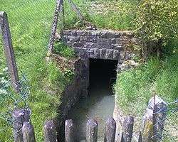 The official source of the Lieser near Boxberg | |
| Location |
Eifel; counties of Vulkaneifel and Bernkastel-Wittlich; Rhineland-Palatinate |
| Reference no. | DE: 2678 |
| Physical characteristics | |
| Main source |
In the High Eifel near Boxberg ca. 560 m above sea level (NHN) [1] 50°16′19″N 6°51′23″E / 50.272000°N 6.856306°ECoordinates: 50°16′19″N 6°51′23″E / 50.272000°N 6.856306°E |
| River mouth |
Near Lieser into the Moselle ca. 108 m above sea level (NHN) [1] 49°54′56″N 7°00′32″E / 49.915611°N 7.00889°E |
| Length | 73.6 km [2] |
| Discharge |
|
| Basin features | |
| Progression | Moselle→ Rhine→ North Sea |
| Basin size | 402.4 km² [2] |
| Landmarks | Small towns: Daun, Wittlich |
| Tributaries |
|
The Lieser is a small river in Rhineland-Palatinate, Germany, a left tributary of the Moselle. It rises in the Eifel, near Boxberg, north of Daun. The Lieser flows south through Daun, Manderscheid and Wittlich. It flows into the Moselle west of the village of Lieser.
References
- 1 2 Official topographic map, 1:25,000 series.
- 1 2 Geoexplorer of the Rhineland-Palatinate Water Authority (Wasserwirtschaftsverwaltung Rheinland-Pfalz)
- ↑ Pegel Plein, Data by the LfU Rhineland-Palatinate
| Wikimedia Commons has media related to Lieser (river). |
Tributaries of the river Moselle | ||
|---|---|---|
| From the left | ||
| From the right | ||
This article is issued from
Wikipedia.
The text is licensed under Creative Commons - Attribution - Sharealike.
Additional terms may apply for the media files.