Little Hope, Wisconsin
| Little Hope, Wisconsin | |
|---|---|
| Unincorporated community | |
 Looking east at the sign for Little Hope | |
 Little Hope, Wisconsin  Little Hope, Wisconsin | |
| Coordinates: 44°19′06″N 89°06′32″W / 44.31833°N 89.10889°WCoordinates: 44°19′06″N 89°06′32″W / 44.31833°N 89.10889°W | |
| Country | United States |
| State | Wisconsin |
| County | Waupaca |
| Elevation | 843 ft (257 m) |
| Time zone | UTC-6 (Central (CST)) |
| • Summer (DST) | UTC-5 (CDT) |
| Area code(s) | 920 |
| GNIS feature ID | 1568279[1] |
Little Hope is an unincorporated community in the town of Dayton, in Waupaca County, Wisconsin, United States.[1] Little Hope is located on County Highway K 3 miles (4.8 km) south-southwest of Waupaca.

Looking north in Little Hope
Notes
Municipalities and communities of Waupaca County, Wisconsin, United States | ||
|---|---|---|
| Cities | 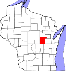 | |
| Villages | ||
| Towns | ||
| CDPs | ||
| Unincorporated communities | ||
| Ghost towns/neighborhoods | ||
| Footnotes | ‡This populated place also has portions in an adjacent county or counties | |
This article is issued from
Wikipedia.
The text is licensed under Creative Commons - Attribution - Sharealike.
Additional terms may apply for the media files.