List of impact craters on Earth
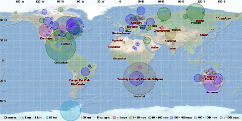
This list of impact craters on Earth contains a selection of the 190 confirmed craters given in the Earth Impact Database.[1] To keep the lists manageable, only the largest craters within a time period are included. The complete list is divided into separate articles by geographical region.
Confirmed impact craters listed by size and age
These features were caused by the collision of meteors (consisting of large fragments of asteroids) or comets (consisting of ice, dust particles and rocky fragments) with the Earth. For eroded or buried craters, the stated diameter typically refers to the best available estimate of the original rim diameter, and may not correspond to present surface features. Time units are either in thousands (ka) or millions (Ma) of years.
Young craters (10 ka or less)
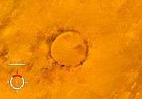
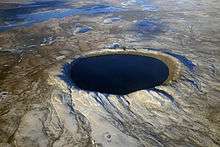
Less than ten thousand years old, and with a diameter of 0.1 km (100 meters) or more. The EID lists only 7 or 8 such craters, and the largest in the last 100,000 years (100 ka) is the 4.5 km Rio Cuarto crater in Argentina.[2] However, there is some uncertainty regarding its origins[3] and age, with some sources giving it as < 10 ka[2][4] while the EID gives a broader < 100 ka.[3]
The Kaali impacts (c. 2000 BC) during the Iron Age may have influenced Estonian and Finnish mythology,[5] the Campo del Cielo (c. 2000 BC) could be in the legends of some Native American tribes,[6][7] while Henbury (c. 2200 BC) has figured in Australian Aboriginal oral traditions.[8]

| Name | Location | Country | Diameter (approx. in km) |
Age (thousand years) |
Date | Coordinates |
|---|---|---|---|---|---|---|
| Wabar | Rub' al Khali desert | Saudi Arabia | 0.1 | 0.2 | ~1800 AD | 21°30′N 50°28′E / 21.500°N 50.467°E |
| Kaali | Saaremaa | Estonia | 0.1 | 4.0 | 1500 BC | 58°24′N 22°40′E / 58.400°N 22.667°E |
| Campo del Cielo | Chaco | Argentina | 0.1[7] | 4.0 | 2000 BC | 27°38′S 61°42′W / 27.633°S 61.700°W |
| Henbury | Northern Territory | Australia | 0.2 | 4.2 | 2200 BC | 24°34′S 133°8′E / 24.567°S 133.133°E |
| Morasko | Poznań | Poland | 0.1 | 5.0[9] | 3000 BC | 52°29′N 16°54′E / 52.483°N 16.900°E |
| Boxhole | Northern Territory | Australia | 0.2 | 5.4 | 3400 BC | 22°37′S 135°12′E / 22.617°S 135.200°E |
| Macha | Sakha Republic | Russia | 0.3 | 7.3 | 5300 BC | 60°6′N 117°35′E / 60.100°N 117.583°E |
| Rio Cuarto (disputed) | Córdoba Province | Argentina | 4.5 | <10?[2][4] | <8000 BC | 32°52.7′S 64°13.4′W / 32.8783°S 64.2233°W |
For the Rio Cuarto craters, 2002 research suggests they may actually be aeolian structures.[10] The EID gives a size of about 50 meters for Campo del Cielo, but other sources quote 100 meters.[7]
Large craters (10 ka to 1 Ma)
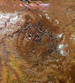
From between 10 thousand years to 1 million years ago, and with a diameter of 1 km or more. The largest in the last one million years is the 14-km Zhamanshin crater in Kazakhstan and has been described as being capable of producing a nuclear-like winter.[11]
However, the currently unknown source of the enormous Australasian strewnfield (c. 780 ka) could be a crater about 100 km across.[12][13]
| Name | Location | Country | Diameter (km) | Age (thousand years) | Coordinates |
|---|---|---|---|---|---|
| Tenoumer | Sahara Desert | Mauritania | 1.9 | 21 | 22°55′5″N 10°24′27″W / 22.91806°N 10.40750°W |
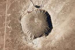
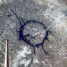
| Meteor Crater | Arizona | United States | 1.2 | 49 | 35°2′N 111°1′W / 35.033°N 111.017°W |
| Xiuyan | Xiuyan | China | 1.8 | 50 | 40°21′N 123°27′E / 40.350°N 123.450°E |
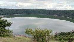
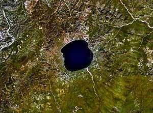
| Lonar | Maharashtra | India | 1.8 | 52 | 19°58′N 76°31′E / 19.967°N 76.517°E |
| Agoudal[14] | Atlas Mountains | Morocco | 3.0 | 105 | 31°59′N 5°30′W / 31.983°N 5.500°W |
| Tswaing | Pretoria Saltpan | South Africa | 1.1 | 220 | 25°24′32″S 28°4′58″E / 25.40889°S 28.08278°E |
| Zhamanshin | Kazakhstan | Kazakhstan | 14.0 | 900 ± 100 | 48°24′N 60°58′E / 48.400°N 60.967°E |
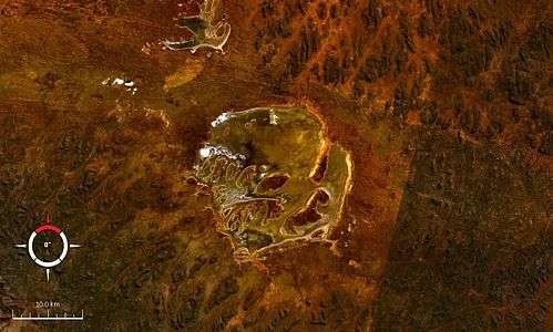
Larger craters (1 Ma to 10 Ma)
From between 1 and 10 million years ago, and with a diameter of 5 km or more. If uncertainties regarding its age are resolved, then the largest in the last 10 million years would be the 52-km Karakul crater which is listed in EID with an age of less than 5 Ma, or the Pliocene. The large but apparently craterless Eltanin impact (2.5 Ma) into the Pacific Ocean has been suggested as contributing to the glaciations and cooling during the Pliocene.[15]
| Name | Location | Country | Diameter (km) | Age (million years) | Coordinates |
|---|---|---|---|---|---|
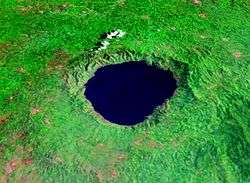
| Bosumtwi | Ashanti | Ghana | 10 | 1.1 | 6°30.3′N 1°24.5′W / 6.5050°N 1.4083°W |
| Elgygytgyn | Chukotka Autonomous Okrug | Russia | 18 | 3.5 | 67°30′N 172°00′E / 67.500°N 172.000°E |
| Bigach | Kazakhstan | Kazakhstan | 8 | 5.0 | 48°34′N 82°1′E / 48.567°N 82.017°E |
| Karla | Tatarstan | Russia | 10 | 5.0 | 54°55′N 48°2′E / 54.917°N 48.033°E |
| Karakul | Pamir Mountains | Tajikistan | 52 | <5?[16][17] | 39°1′N 73°27′E / 39.017°N 73.450°E |
Largest craters (10 Ma or more)
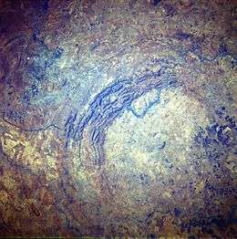
Craters with a diameter of 20 km or more are all older than 10 Ma, with the exception of Karakul whose age is uncertain. There are more than forty such craters. The largest two within the last hundred million years have been linked to two extinction events: Chicxulub for the Cretaceous–Paleogene and the Popigai impact for the Eocene–Oligocene extinction event.[18]


Large unconfirmed craters
The largest unconfirmed craters 200 km or more are significant not only for their size, but also for the possible coeval events associated with them. For example, the Wilkes Land crater has been connected to the massive Permian–Triassic extinction event.[20] The sortable table has been arranged by diameter.
| Name | Location | Country | Diameter (km) | Age (million years) | Coordinates |
|---|---|---|---|---|---|
| Mistassini-Otish impact crater[21] | Quebec | Canada | 600 | 2100 | 50°00′N 71°00′W / 50.000°N 71.000°W |
| Australian impact structure | Northern Territory | Australia | 600 | 545 | |
| Shiva crater | offshore of India | India | 500 | 65 | |
| Wilkes Land crater | Wilkes Land | Antarctica | 480-500 | 250-500 | |
| Nastapoka arc | Nunavut/Quebec | Canada | 450 | unknown | 57°00′N 78°50′W / 57.000°N 78.833°W |
| Czech Crater | Central Europe | Czech Republic | 300-500 | 2000 | 49°28′N 14°24′E / 49.467°N 14.400°E |
| Ishim impact structure[22] | Akmola Region | Kazakhstan | 300 | 460-430[23] | 52°0′N 69°0′E / 52.000°N 69.000°E |
| Bedout | offshore of Western Australia | Australia | 250 | 250 | |
| Falkland (Malvinas) Plateau anomaly[24][25][26] | offshore of South America | Falkland Islands | 250 | 250 (uncertain, estimated to be Late Palaeozoic) | 51°0′S 62°0′W / 51.000°S 62.000°W |
| East Warburton Basin | Southern Australia | Australia | 200+ | 300-360 |
All craters listed alphabetically
As of 2017, the Earth Impact Database (EID) contains 190 confirmed craters. The table below is arranged by the continent's percentage of the Earth's land area, and where Asian and Russian craters are grouped together per EID convention. The global distribution of known impact structures apparently shows a surprising asymmetry,[27] with the small but well-funded European continent having a large percentage of confirmed craters. It is suggested this situation is an artifact, highlighting the importance of intensifying research in less studied areas like Antarctica, South America and elsewhere.[27]
.svg.png)
.svg.png)
.svg.png)
.svg.png)
.svg.png)
| Continent | Continent's % of Earth's land area | Continent's % of the 190 known craters | Number of craters |
|---|---|---|---|
| Asia & Russia | 30% | 16% | 31 |
| Africa | 20% | 11% | 20 |
| North America | 16% | 32% | 60 |
| South America | 12% | 6% | 11 |
| Antarctica | 9% | 0% | 0 |
| Europe | 7% | 22% | 41 |
| Australia | 6% | 14% | 27 |
| Total | 100% | 100% | 190 |
See also
- Bolides
- Earth Impact Database
- Extinction event
- Impact events
- Impact Field Studies Group
- List of unconfirmed impact craters on Earth
- Traces of Catastrophe book from Lunar and Planetary Institute - comprehensive reference on impact crater science
- Giant-impact hypothesis
References
- ↑ "Earth Impact Database".
- 1 2 3 Bland, Phil A.; de Souza Filho, C. R.; Timothy Jull, A. J.; Kelley, Simon P.; Hough, Robert Michael; Artemieva, N. A.; Pierazzo, E.; Coniglio, J.; Pinotti, Lucio; Evers, V.; Kearsley, Anton; (2002); "A possible tektite strewn field in the Argentinian Pampa", Science, volume 296, issue 5570, pp. 1109-1112
- 1 2 "Rio Cuarto". Earth Impact Database. University of New Brunswick. Retrieved 2009-08-19.
- 1 2 Schultz, Peter H.; Lianza, Ruben E.; (1992) "Recent grazing impacts on the Earth recorded in the Rio Cuarto crater field, Argentina", Nature 355, p. 234-237 (16 January 1992)
- ↑ Haas, Ain; Peekna, Andres; Walker, Robert E. "Echoes of Ancient Cataclysms in the Baltic Sea" (PDF). Electronic Journal of Folklore. Retrieved 2008-10-26.
- ↑ Benítez, Giménez; López, Alejandro M.; Mammana, Luis A. "Meteorites of Campo del Cielo: Impact on the indian culture".
- 1 2 3 Bobrowsky, Peter T.; Rickman, Hans (2007). Comet/asteroid impacts and human society: an interdisciplinary approach. Springer. pp. 30–31. ISBN 3-540-32709-6.
- ↑ Hamacher, Duane W.; Goldsmith, John. "Aboriginal oral traditions of Australian impact craters" (PDF).
- ↑ Stankowski, Wojciech; Raukas, Anto; Bluszcz, Andrzej; Fedorowicz, Stanisław. "Luminescence dating of the Morasko (Poland), Kaali, Ilumetsa, and Tsõõrikmäe (Estonia) meteorite craters" (PDF).
- ↑ Cione, Alberto L. et al. (2002). Putative Meteoritic Craters in Río Cuarto (Central Argentina) Interpreted as Eolian Structures, Earth, Moon, and Planets 91 (1), 9-24.
- ↑ Essay "Impact Cratering on Earth", based on: Grieve, Richard A. F.; (1990); "Impact cratering on the Earth", Scientific American, vol. 262, 66-73
- ↑ Povenmire, Harold; Liu, W.; Xianlin, Luo; (1999) "Australasian tektites found in Guangxi Province, China", in Proceedings of the 30th Annual Lunar and Planetary Science Conference, Houston, March 1999
- ↑ Glass, Billy P.; Pizzuto, James E.; (1994) "Geographic variation in Australasian microtektite concentrations: Implications concerning the location and size of the source crater", Journal of Geophysical Research, vol. 99, no. E9, 19075-19081, September 1994
- ↑ "Agoudal". Earth Impact Database. University of New Brunswick. Retrieved 2016-08-18.
- ↑ University of New South Wales (19 September 2012). "Did a Pacific Ocean meteor trigger the Ice Age?". Retrieved 8 October 2012.
- ↑ "Kara-Kul". Earth Impact Database. University of New Brunswick. Retrieved 2009-08-15.
- ↑ Gurov, Eugene P.; Gurova, H. P.; Rakitskaya, R. B.; Yamnichenko, A. Yu. (1993). "The Karakul depression in Pamirs - the first impact structure in central Asia" (PDF). Lunar and Planetary Science. XXIV: 591–592.
- ↑ "Russia's Popigai Meteor Crash Linked to Mass Extinction". 13 June 2014.
- ↑ Cohen, Benjamin E.; Mark, Darren F.; Lee, Martin R.; Simpson, Sarah L. (2017-08-01). "A new high-precision 40Ar/39Ar age for the Rochechouart impact structure: At least 5 Ma older than the Triassic–Jurassic boundary". Meteoritics & Planetary Science. 52 (8): 1600–1611. Bibcode:2017M&PS...52.1600C. doi:10.1111/maps.12880. ISSN 1945-5100.
- ↑ Gorder, Pam Frost (1 June 2006). "Big Bang in Antarctica – Killer Crater Found Under Ice". Ohio State University Research News. Archived from the original on 6 March 2016.
- ↑ Genest, Serge; Robert, Francine; "The Mistassini-Otish Impact Structure, Northern Quebec, Canada: An Update", Proceedings of the 80th Annual Meeting of the Meteoritical Society, 2017
- ↑ Dachille, Frank. "Frequency of the formation of large terrestrial impact craters".
- ↑ Zeylik, B. S.; Seytmuratova, E. Yu; (1974); "A meteorite-impact structure in central Kazakhstan and its magmatic-ore controlling role", Doklady Akademii Nauk SSSR, 1, pages 167-170
- ↑ Rocca, Maximiliano C. L.; Presser, Jaime Leonardo Báez; (2015) "A possible new very large impact structure in Malvinas Islands", Historia Natural, Tercera Series, Volumen 5(2)
- ↑ Rocca, Maximiliano C. L.; Rampino, Michael R.; Presser, Jaime Leonardo Báez (2017). "Geophysical evidence for a large impact structure on the Falkland (Malvinas) Plateau".
- ↑ Osborne, Hannah (5 May 2017). "Crater Potentially Linked to the Biggest Mass Extinction Event in Earth's History is Discovered". Newsweek Tech & Science.
- 1 2 Prezzi, Claudia B.; Orgeira, María Julia; Acevedo, Rogelio D.; Ponce, Juan Federico; Martinez, Oscar; Rabassa, Jorge O.; Corbella, Hugo; Vásquez, Carlos; González-Guillot, Mauricio; Subías, Ignacio; (2011); "Geophysical characterization of two circular structures at Bajada del Diablo (Patagonia, Argentina): Indication of impact origin", Physics of the Earth and Planetary Interiors, volume 192, p. 21-34
External links
- Impact Database (formerly Suspected Earth Impact Sites list) maintained by David Rajmon for Impact Field Studies Group, USA
- Impact Meteor Crater Viewer Google Maps Page with Locations of Meteor Craters around the world