List of impact craters in South America
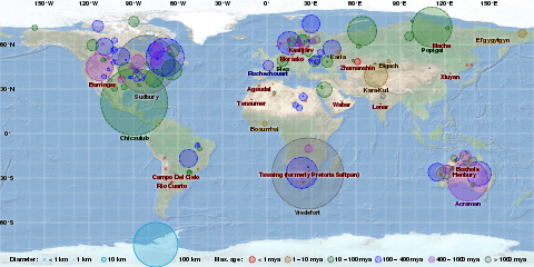
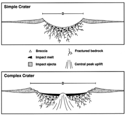
This list includes all 11 confirmed impact craters in South America as listed in the Earth Impact Database. These features were caused by the collision of large meteorites or comets with the Earth. For eroded or buried craters, the stated diameter typically refers to an estimate of original rim diameter, and may not correspond to present surface features.
Confirmed impact craters
| Name | Location | Diameter | Age (years) | Coordinates |
|---|---|---|---|---|
| Araguainha | Brazil | 40 km | 244.40 ± 3.25 million | 16°47′S 52°59′W / 16.783°S 52.983°W |
| Campo del Cielo | Argentina | 0.05 km | < 4000 | 27°38′S 61°42′W / 27.633°S 61.700°W |
| Carancas | Peru | 0.0135 km | 10 | 16°40′S 69°03′W / 16.667°S 69.050°W |
| Colônia | Brazil | 3.6 km | >5,<36 | 23°52′S 46°42′W / 23.867°S 46.700°W |
| Monturaqui | Chile | 0.46 km | < 1 million | 23°56′S 68°16′W / 23.933°S 68.267°W |
| Riachão Ring | Brazil | 4.5 km | < 200 million | 7°43′S 46°39′W / 7.717°S 46.650°W |
| Rio Cuarto | Argentina | 4.5 km (largest of 10) | < 100,000 | 32°53′S 64°14′W / 32.883°S 64.233°W |
| Santa Marta | Brazil | 10 km | 66-100 | 10°10′S 45°15′W / 10.167°S 45.250°W |
| Serra da Cangalha | Brazil | 12 km | < 300 million | 8°5′S 46°52′W / 8.083°S 46.867°W |
| Vargeão Dome | Brazil | 12 km | < 70 million | 26°50′S 52°7′W / 26.833°S 52.117°W |
| Vista Alegre | Brazil | 9.5 km | < 65 million | 25°57′S 52°41′W / 25.950°S 52.683°W |
Unconfirmed impact craters
The following craters are officially considered "unconfirmed" because they are not listed in the Earth Impact Database. Due to stringent requirements regarding evidence and peer-reviewed publication, newly discovered craters or those with difficulty collecting evidence generally are known for some time before becoming listed. However, entries on the unconfirmed list could still have an impact origin disproven.
| Name | Location | Diameter | Age | Coordinates |
|---|---|---|---|---|
| Cerro do Jarau crater[1] | Brazil | 10 km (6.2 mi) | ? | 30°12′S 56°32′W / 30.200°S 56.533°W |
| Iturralde | Bolivia | 8 km (5.0 mi) | 11–30 thousand | 12°35′S 67°40′W / 12.583°S 67.667°W |
| Piratininga crater | Paraná Basin, Brazil | 12 km (7.5 mi) | 117 million | 22°28′12″S 49°09′00″W / 22.47000°S 49.15000°W |
| Praia Grande[1] | Santos Basin, Brazil | 20 km (12 mi) | 84 million | 25°39′S 45°37′W / 25.650°S 45.617°W |
| Vichada Structure | Colombia | 50 km (31 mi) | 30 million | 4°30′N 69°15′W / 4.500°N 69.250°W |
See also
- Impact craters
- Impact events
- Bolides and Meteorites
- Earth Impact Database – primary source
- Traces of Catastrophe book from Lunar and Planetary Institute - comprehensive reference on impact crater science
References
External links
- Earth Impact Database – List of confirmed earth impact sites at the Planetary and Space Science Centre, University of New Brunswick
- Impact Database (formerly Suspected Earth Impact Sites list) maintained by David Rajmon for Impact Field Studies Group, USA