List of cultural property of national significance in Switzerland: Thurgau
This list contains all cultural property of national significance (class A) in the canton of Thurgau from the 2009 Swiss Inventory of Cultural Property of National and Regional Significance. It is sorted by municipality.
The geographic coordinates provided are in the Swiss coordinate system as given in the Inventory.
Aadorf
| KGS No.? |
Picture | Name | Street Address | CH1903 X coordinate | CH1903 Y coordinate | Location |
|---|---|---|---|---|---|---|
| 8589 | Agrotechnorama Tänikon | Tänikon | 710.651 | 259.829 | 47°28′48″N 8°54′24″E / 47.479915°N 8.90669°E | |
| 5053 |  |
Former Monastery Church of St Bernhard | Tänikon | 710.685 | 259.781 | 47°28′46″N 8°54′26″E / 47.479477°N 8.907129°E |
Altnau
| KGS No.? |
Picture | Name | Street Address | CH1903 X coordinate | CH1903 Y coordinate | Location |
|---|---|---|---|---|---|---|
| Unknown | ISOS Village: Altnau |
Amlikon-Bissegg
| KGS No.? |
Picture | Name | Street Address | CH1903 X coordinate | CH1903 Y coordinate | Location |
|---|---|---|---|---|---|---|
| Unknown | ISOS Hamlet: Leutmerken | |||||
| Unknown | ISOS Spezialfall: Griesenberg |
Amriswil
| KGS No.? |
Picture | Name | Street Address | CH1903 X coordinate | CH1903 Y coordinate | Location |
|---|---|---|---|---|---|---|
| 10150 |  |
Bohlenständerhaus Schrofen | Kreuzlingerstrasse 66 | 738.106 | 268.273 | 47°33′02″N 9°16′24″E / 47.550647°N 9.273451°E |
| 8540 | Kutschensammlung Sallmann | St Gallerstrasse 12 | 739.944 | 267.454 | 47°32′34″N 9°17′51″E / 47.542894°N 9.297603°E | |
| 4910 | 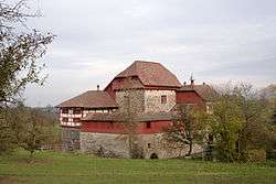 |
Hagenwil Castle | Hagenwil 1 | 740.554 | 265.937 | 47°31′45″N 9°18′19″E / 47.529124°N 9.305224°E |
| Unknown | ISOS Village: Hagenwil bei Amriswil |
Arbon
| KGS No.? |
Picture | Name | Street Address | CH1903 X coordinate | CH1903 Y coordinate | Location |
|---|---|---|---|---|---|---|
| 4917 | Bleiche, Prehistoric Lake Shore Settlement |
749.850 | 263.350 | 47°30′14″N 9°25′40″E / 47.50381°N 9.427758°E | ||
| 10232 | 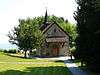 |
Gallus Chapel | Gallusgasse 4 | 750.569 | 264.608 | 47°30′54″N 9°26′16″E / 47.514956°N 9.437723°E |
| 10234 | 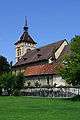 |
Catholic Church of St Martin | Bahnhofstrasse 7 | 750.530 | 264.633 | 47°30′55″N 9°26′14″E / 47.51519°N 9.437214°E |
| 4918/extendedHtmlPopup 10646, 4918 | 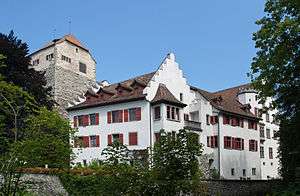 |
Arbon Castle and Historical Museum | Schloss 4 | 750.511 | 264.685 | 47°30′56″N 9°26′13″E / 47.515662°N 9.436979°E |
| 9676 |  |
Late-Roman Fortress | 750.560 | 264.600 | 47°30′54″N 9°26′15″E / 47.514887°N 9.437601°E | |
| Unknown | ISOS Kleinstadt / Flecken: Arbon | |||||
| Unknown | ISOS hamlet: Kratzern |
Berg
| KGS No.? |
Picture | Name | Street Address | CH1903 X coordinate | CH1903 Y coordinate | Location |
|---|---|---|---|---|---|---|
| Unknown | ISOS hamlet: Hard | |||||
| Unknown | ISOS hamlet: Kehlhof |
Berlingen
| KGS No.? |
Picture | Name | Street Address | CH1903 X coordinate | CH1903 Y coordinate | Location |
|---|---|---|---|---|---|---|
| Unknown | ISOS Village: Berlingen |
Bettwiesen
| KGS No.? |
Picture | Name | Street Address | CH1903 X coordinate | CH1903 Y coordinate | Location |
|---|---|---|---|---|---|---|
| 4934 |  |
Bettwiesen Castle | 719.878 | 261.798 | 47°29′46″N 9°01′47″E / 47.496003°N 9.029607°E |
Bischofszell
| KGS No.? |
Picture | Name | Street Address | CH1903 X coordinate | CH1903 Y coordinate | Location |
|---|---|---|---|---|---|---|
| 4937 | 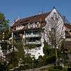 |
Daller House | Kirchgasse 5 | 735.749 | 261.831 | 47°29′36″N 9°14′25″E / 47.493215°N 9.240183°E |
| 4938 |  |
Double House Rebstock / Rosenstock | Marktgasse 7 | 735.725 | 261.899 | 47°29′38″N 9°14′24″E / 47.493831°N 9.239886°E |
| 4939 |  |
Former Paper Factory with Paper Machine PM1 | Fabrikstrasse 26 | 735.364 | 261.800 | 47°29′35″N 9°14′06″E / 47.493016°N 9.235066°E |
| 8457/extendedHtmlPopup 4940, 8457 |  |
Houses and the map collection of the Dr. Albert Knoepfli collection in the Museum Bischofszell |
Marktgasse 4, 6 | 735.758 | 261.879 | 47°29′37″N 9°14′25″E / 47.493645°N 9.240317°E |
| 4941 | 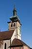 |
Catholic Church of St Pelagius with Michaels Chapel | Kirchgasse 16 | 735.628 | 261.900 | 47°29′38″N 9°14′19″E / 47.49386°N 9.238599°E |
| 4942 | 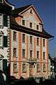 |
Rathaus (Town council house) | Marktgasse 11 | 735.712 | 261.916 | 47°29′38″N 9°14′23″E / 47.493987°N 9.239718°E |
| 4943 | 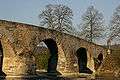 |
Alte Thurbrücke | 735.160 | 261.647 | 47°29′30″N 9°13′56″E / 47.491682°N 9.232313°E | |
| Unknown | ISOS Kleinstadt / Flecken: Bischofszell |
Bürglen
| KGS No.? |
Picture | Name | Street Address | CH1903 X coordinate | CH1903 Y coordinate | Location |
|---|---|---|---|---|---|---|
| Unknown | ISOS Kleinstadt / Flecken: Bürglen |
Bussnang
| KGS No.? |
Picture | Name | Street Address | CH1903 X coordinate | CH1903 Y coordinate | Location |
|---|---|---|---|---|---|---|
| Unknown | ISOS Hamlet: Wertbühl |
Diessenhofen
| KGS No.? |
Picture | Name | Street Address | CH1903 X coordinate | CH1903 Y coordinate | Location |
|---|---|---|---|---|---|---|
| 4961 |  |
Unterhof Castle | Kirchgasse 15 | 698.282 | 282.979 | 47°41′24″N 8°44′52″E / 47.690053°N 8.747736°E |
| 11770 | Town Archive in the Rathaus (Town council house) | Hintergasse 49 | 698.610 | 282.966 | 47°41′24″N 8°45′08″E / 47.689887°N 8.752101°E | |
| 5213 | Former Dominican Monastery of St. Katharinental | Willisdorf | 697.428 | 283.132 | 47°41′30″N 8°44′11″E / 47.691556°N 8.736397°E | |
| 8455/extendedHtmlPopup 4956, 8455 | 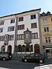 |
Zum Goldenen Löwen House and Goldener Leuen Collection | Hauptstrasse 8 | 698.449 | 282.902 | 47°41′22″N 8°45′00″E / 47.689336°N 8.749943°E |
| 9055 | 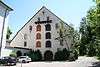 |
Granary of the former Dominican Monastery of St. Katharinental | Willisdorf | 697.211 | 283.068 | 47°41′28″N 8°44′01″E / 47.691013°N 8.733493°E |
| 4955 |  |
Rheinbrücke (Rhine Bridge) | Rheinhalde | 698.510 | 283.058 | 47°41′27″N 8°45′03″E / 47.690729°N 8.75079°E |
| 10235 |  |
City Walls with Siegelturm | 698.590 | 282.893 | 47°41′21″N 8°45′07″E / 47.689233°N 8.751819°E | |
| Unknown | ISOS Kleinstadt / Flecken: Diessenhofen | |||||
| Unknown | ISOS Spezialfall: St Katharinental |
Egnach
| KGS No.? |
Picture | Name | Street Address | CH1903 X coordinate | CH1903 Y coordinate | Location |
|---|---|---|---|---|---|---|
| 4975 | 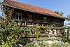 |
Bohlenständerhaus | Erdhausen | 744.892 | 266.611 | 47°32′03″N 9°21′47″E / 47.534242°N 9.363031°E |
| 4969 | Farm House Schär mit Speicher | Ackermannshub | 744.199 | 266.649 | 47°32′05″N 9°21′14″E / 47.534736°N 9.353843°E | |
| Unknown | ISOS Village: Steinebrunn | |||||
| Unknown | ISOS Spezialfall: Kulturlandschaft Balgen |
Erlen
| KGS No.? |
Picture | Name | Street Address | CH1903 X coordinate | CH1903 Y coordinate | Location |
|---|---|---|---|---|---|---|
| Unknown | ISOS Verstädtertes Village: Erlen-Eppishausen |
Ermatingen
| KGS No.? |
Picture | Name | Street Address | CH1903 X coordinate | CH1903 Y coordinate | Location |
|---|---|---|---|---|---|---|
| 10236 | 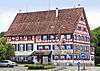 |
Gasthaus Adler | Fruthwilerstrasse 2 | 723.244 | 281.119 | 47°40′09″N 9°04′47″E / 47.66911°N 9.079625°E |
| 10237 |  |
Kehlhof | Kehlhofstrasse 8 | 723.219 | 281.193 | 47°40′11″N 9°04′46″E / 47.66978°N 9.079313°E |
| 4989 |  |
Paritätische Church of St Albin | Kirchgasse | 723.300 | 281.200 | 47°40′11″N 9°04′49″E / 47.669827°N 9.080393°E |
| 4994 | Westerfeld / Büge (prehistoric shoreline settlement) | 722.670 | 281.550 | 47°40′23″N 9°04′20″E / 47.673093°N 9.072104°E | ||
| Unknown | ISOS Village: Ermatingen | |||||
| Unknown | ISOS Village: Triboltingen | |||||
| Unknown | ISOS Spezialfall: Untersee (Ermatingen, Gottlieben, Kreuzlingen, Salenstein, Tägerwilen) |
Eschenz
| KGS No.? |
Picture | Name | Street Address | CH1903 X coordinate | CH1903 Y coordinate | Location |
|---|---|---|---|---|---|---|
| 10238 |  |
Werd Island (Prehistoric Shoreline Settlement / Roman Vicus / Roman Bridge) | 707.250 | 279.300 | 47°39′20″N 8°51′59″E / 47.655565°N 8.866274°E | |
| 4996 |  |
Freudenfels Castle | 709.070 | 277.490 | 47°38′20″N 8°53′24″E / 47.63899°N 8.89005°E | |
| 4995 |  |
Pilgrimage Chapel St Otmar | Insel Werd | 707.306 | 279.254 | 47°39′19″N 8°52′01″E / 47.655143°N 8.867008°E |
| Unknown | ISOS Spezialfall: Eschenzer (Eschenz, Mammern) |
Fischingen
| KGS No.? |
Picture | Name | Street Address | CH1903 X coordinate | CH1903 Y coordinate | Location |
|---|---|---|---|---|---|---|
| 5005 |  |
St Martins Chapel | Oberwangen | 715.780 | 254.354 | 47°25′47″N 8°58′24″E / 47.429799°N 8.973302°E |
| 10239 | 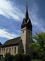 |
Catholic Church of Dussnang | Kurhausstrasse | 714.967 | 254.386 | 47°25′49″N 8°57′45″E / 47.430229°N 8.962537°E |
| 5003 | 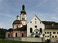 |
Benedictine Fischingen Abbey (now Priory) with Church and Idda Chapel |
715.479 | 252.389 | 47°24′44″N 8°58′08″E / 47.412181°N 8.968806°E | |
| 10486 |  |
Ruins of Tannegg Castle | 714.060 | 254.390 | 47°25′50″N 8°57′02″E / 47.430423°N 8.950518°E | |
| Unknown | ISOS Spezialfall: Monastery Fischingen |
Frauenfeld
| KGS No.? |
Picture | Name | Street Address | CH1903 X coordinate | CH1903 Y coordinate | Location |
|---|---|---|---|---|---|---|
| 11612 | Archive of the Amtes für Denkmalpflege in Canton Thurgau |
Ringstrasse 16 | 710.202 | 268.288 | 47°33′22″N 8°54′10″E / 47.556056°N 8.902827°E | |
| 10527/extendedHtmlPopup 5015, 10527 | Archive of the Department of Archeology | Schlossmühlestrasse 15a | 709.818 | 268.000 | 47°33′13″N 8°53′52″E / 47.55353°N 8.897655°E | |
| 8882 | Citizen's Archive of Frauenfeld | Stadtgartenweg 1 | 709.945 | 267.802 | 47°33′06″N 8°53′57″E / 47.551729°N 8.899293°E | |
| 9346 | Cantonal Library Thurgau | Promenadenstrasse 12 | 709.946 | 268.300 | 47°33′22″N 8°53′58″E / 47.556207°N 8.899429°E | |
| 5016 | 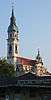 |
Catholic City Church | Zürcherstrasse 181 | 709.830 | 268.400 | 47°33′26″N 8°53′52″E / 47.557125°N 8.897913°E |
| 8456/extendedHtmlPopup 8584, 8456 | Museum of Archeology and Natural History of the Canton of Thurgau |
Freie-Strasse 26 | 709.884 | 268.340 | 47°33′24″N 8°53′55″E / 47.556577°N 8.898616°E | |
| 5018 | 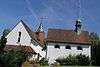 |
Simultaneum Church of St Laurenzen with St Anna Chapel and Messmerhaus |
Oberkirchstrasse | 710.917 | 268.953 | 47°33′43″N 8°54′45″E / 47.561915°N 8.912491°E |
| 5019 | 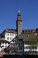 |
Rathaus (Town council house) | Rathausplatz 4 | 709.805 | 268.201 | 47°33′19″N 8°53′51″E / 47.55534°N 8.897532°E |
| 8464/extendedHtmlPopup 5020, 8464 | 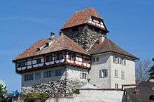 |
Frauenfeld Castle and Historical Museum of the Canton of Thurgau |
Rathausplatz 2 | 709.756 | 268.183 | 47°33′19″N 8°53′49″E / 47.555186°N 8.896877°E |
| 8818 | State Archives of the Canton of Thurgau |
Zürcherstrasse 221 | 710.015 | 268.615 | 47°33′33″N 8°54′02″E / 47.559028°N 8.900424°E | |
| Unknown | ISOS Stadt: Frauenfeld |
Gachnang
| KGS No.? |
Picture | Name | Street Address | CH1903 X coordinate | CH1903 Y coordinate | Location |
|---|---|---|---|---|---|---|
| 5125 | 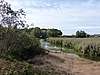 |
Egelsee (prehistoric shore front settlement) | 707.125 | 268.400 | 47°33′27″N 8°51′43″E / 47.557572°N 8.86198°E | |
| 5076 | 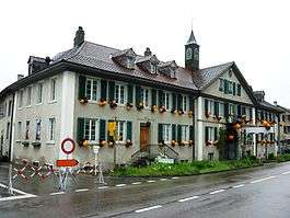 |
Former Manufaktur Greuterhof mit Scheune | Islikon | 705.531 | 266.928 | 47°32′41″N 8°50′26″E / 47.544593°N 8.840456°E |
Gottlieben
| KGS No.? |
Picture | Name | Street Address | CH1903 X coordinate | CH1903 Y coordinate | Location |
|---|---|---|---|---|---|---|
| 5048 |  |
Gottlieben Castle | Am Schlosspark 4 | 727.491 | 280.644 | 47°39′50″N 9°08′10″E / 47.664027°N 9.136021°E |
| Unknown | ISOS Spezialfall: Gottlieben | |||||
| Unknown | ISOS Spezialfall: Untersee (Ermatingen, Gottlieben, Kreuzlingen, Salenstein, Tägerwilen) |
Hauptwil-Gottshaus
| KGS No.? |
Picture | Name | Street Address | CH1903 X coordinate | CH1903 Y coordinate | Location |
|---|---|---|---|---|---|---|
| 10241 | Former Tavern Zur Traube | Hauptwil, Türmlistrasse 3 | 736.583 | 260.448 | 47°28′50″N 9°15′03″E / 47.480607°N 9.250824°E | |
| 5056 | Hauptwil Castle | 736.654 | 260.430 | 47°28′50″N 9°15′06″E / 47.48043°N 9.25176°E | ||
| 10243 | Tortürmli | Schloss | 736.604 | 260.418 | 47°28′49″N 9°15′04″E / 47.480333°N 9.251093°E | |
| Unknown | ISOS Village: Hauptwil |
Herdern
| KGS No.? |
Picture | Name | Street Address | CH1903 X coordinate | CH1903 Y coordinate | Location |
|---|---|---|---|---|---|---|
| 5059 | 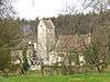 |
Liebenfels Castle | 711.777 | 276.693 | 47°37′53″N 8°55′33″E / 47.631368°N 8.925863°E | |
| Unknown | ISOS Spezialfall: Liebenfels |
Hohentannen
| KGS No.? |
Picture | Name | Street Address | CH1903 X coordinate | CH1903 Y coordinate | Location |
|---|---|---|---|---|---|---|
| Unknown | ISOS Spezialfall: Oetlishausen |
Homburg
| KGS No.? |
Picture | Name | Street Address | CH1903 X coordinate | CH1903 Y coordinate | Location |
|---|---|---|---|---|---|---|
| Unknown | ISOS Hamlet: Gündelhart |
Hüttlingen
| KGS No.? |
Picture | Name | Street Address | CH1903 X coordinate | CH1903 Y coordinate | Location |
|---|---|---|---|---|---|---|
| Unknown | ISOS Village: Hüttlingen |
Hüttwilen
| KGS No.? |
Picture | Name | Street Address | CH1903 X coordinate | CH1903 Y coordinate | Location |
|---|---|---|---|---|---|---|
| 5073 |  |
Former Cistercian Monastery | Kalchrain | 709.088 | 274.385 | 47°36′40″N 8°53′22″E / 47.611067°N 8.889526°E |
| 5184 | Horn / Inseli | Üerschhausen | 703.600 | 274.750 | 47°36′55″N 8°49′00″E / 47.615238°N 8.816634°E | |
| Unknown | ISOS Village: Nussbaumen |
Kemmental
| KGS No.? |
Picture | Name | Street Address | CH1903 X coordinate | CH1903 Y coordinate | Location |
|---|---|---|---|---|---|---|
| Unknown |  |
ISOS Hamlet: Bommen |
Kesswil
| KGS No.? |
Picture | Name | Street Address | CH1903 X coordinate | CH1903 Y coordinate | Location |
|---|---|---|---|---|---|---|
| Unknown | ISOS Village: Kesswil |
Kreuzlingen
| KGS No.? |
Picture | Name | Street Address | CH1903 X coordinate | CH1903 Y coordinate | Location |
|---|---|---|---|---|---|---|
| 5082 |  |
Former Augustinian Chorherrenstift of St. Ulrich | Hauptstrasse 85 | 730.725 | 278.676 | 47°38′45″N 9°10′43″E / 47.645695°N 9.178484°E |
| 9483 |  |
Former Granary and Wine press at Seeburgscheune | Seeweg 3 | 731.518 | 279.038 | 47°38′56″N 9°11′21″E / 47.648791°N 9.189142°E |
| 5083 | 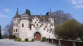 |
Seeburg Castle | Seeweg 5 | 731.329 | 279.116 | 47°38′58″N 9°11′12″E / 47.64953°N 9.18665°E |
| Unknown | ISOS Spezialfall: Untersee (Ermatingen, Gottlieben, Kreuzlingen, Salenstein, Tägerwilen) |
Mammern
| KGS No.? |
Picture | Name | Street Address | CH1903 X coordinate | CH1903 Y coordinate | Location |
|---|---|---|---|---|---|---|
| 5099 |  |
Mammern Castle with Park and Chapel | Ringstrasse | 711.132 | 278.383 | 47°38′48″N 8°55′04″E / 47.646674°N 8.917707°E |
| 5100 | Pilgrimage Church of Mariahilf | Klingenzell | 709.780 | 277.344 | 47°38′15″N 8°53′58″E / 47.637559°N 8.89946°E | |
| Unknown | ISOS Spezialfall:Mammern | |||||
| Unknown | ISOS Spezialfall: Eschenzer Becken (Eschenz, Mammern) |
Märstetten
| KGS No.? |
Picture | Name | Street Address | CH1903 X coordinate | CH1903 Y coordinate | Location |
|---|---|---|---|---|---|---|
| 10222 |  |
Hohes Haus | Kreuzlingerstrasse 9 | 722.536 | 272.738 | 47°35′38″N 9°04′04″E / 47.593884°N 9.067886°E |
| 5104 | 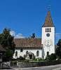 |
Church of St. Jakob | Kirchgasse | 722.636 | 272.744 | 47°35′38″N 9°04′09″E / 47.593919°N 9.069217°E |
| Unknown | ISOS Village: Märstetten | |||||
| Unknown | ISOS Village: Ottoberg | |||||
| Unknown |  |
ISOS hamlet: Boltshausen | ||||
| Unknown | ISOS Spezialfall: Ottenberg Südhang |
Müllheim
| KGS No.? |
Picture | Name | Street Address | CH1903 X coordinate | CH1903 Y coordinate | Location |
|---|---|---|---|---|---|---|
| Unknown | ISOS Spezialfall: Grüneck |
Münchwilen
| KGS No.? |
Picture | Name | Street Address | CH1903 X coordinate | CH1903 Y coordinate | Location |
|---|---|---|---|---|---|---|
| 5116 | 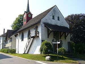 |
St. Margarethen Chapel | Kapellstrasse | 717.761 | 260.703 | 47°29′12″N 9°00′04″E / 47.486539°N 9.001229°E |
Münsterlingen
| KGS No.? |
Picture | Name | Street Address | CH1903 X coordinate | CH1903 Y coordinate | Location |
|---|---|---|---|---|---|---|
| 5120 |  |
Former Benedictine Monastery | Kantonsspital | 734.992 | 277.133 | 47°37′51″N 9°14′05″E / 47.630957°N 9.234786°E |
| 5119 | 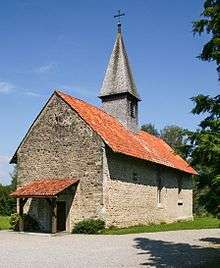 |
Chapel St Leonhard | Landschlacht | 735.751 | 276.554 | 47°37′32″N 9°14′41″E / 47.625595°N 9.244704°E |
| Unknown | ISOS Spezialfall: Münsterlingen |
Neunforn
| KGS No.? |
Picture | Name | Street Address | CH1903 X coordinate | CH1903 Y coordinate | Location |
|---|---|---|---|---|---|---|
| 5132 | _(56).JPG) |
Reformed Church | Kirchgasse | 699.874 | 273.664 | 47°36′22″N 8°46′01″E / 47.60605°N 8.766839°E |
| Unknown | ISOS Village: Niederneunforn | |||||
| Unknown | ISOS Village: OBernunforn | |||||
| Unknown | ISOS Village: Wilen bei Neunforn | |||||
| Unknown | ISOS hamlet: Farhof |
Pfyn
| KGS No.? |
Picture | Name | Street Address | CH1903 X coordinate | CH1903 Y coordinate | Location |
|---|---|---|---|---|---|---|
| 5137 | Ad Fines, Late-Roman Fortress | 714.530 | 272.630 | 47°35′40″N 8°57′41″E / 47.594359°N 8.961436°E | ||
| 9678 |  |
Breitenloo, Prehistoric shore front settlement | 712.300 | 272.600 | 47°35′40″N 8°55′54″E / 47.594474°N 8.931785°E | |
| 10224 |  |
Paritätische Church of St Bartholomäus | Im Städtli | 714.513 | 272.625 | 47°35′40″N 8°57′40″E / 47.594317°N 8.961209°E |
Roggwil
| KGS No.? |
Picture | Name | Street Address | CH1903 X coordinate | CH1903 Y coordinate | Location |
|---|---|---|---|---|---|---|
| 10225 | Gasthof Traube | St Gallerstrasse 68 | 747.448 | 262.898 | 47°30′01″N 9°23′45″E / 47.500289°N 9.395736°E | |
| 5142 | 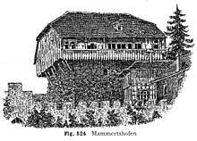 |
Mammertshofen Castle | 747.630 | 262.271 | 47°29′41″N 9°23′53″E / 47.494611°N 9.397943°E | |
| Unknown | ISOS Village: Roggwil (TG) | |||||
| Unknown | ISOS hamlet: Watt bei Roggwil |
Romanshorn
| KGS No.? |
Picture | Name | Street Address | CH1903 X coordinate | CH1903 Y coordinate | Location |
|---|---|---|---|---|---|---|
| 5145 |  |
Old Paritätische Church | Schlossbergstrasse 28 | 746.243 | 270.483 | 47°34′08″N 9°22′56″E / 47.568756°N 9.382241°E |
| 5146 |  |
Harbor with a wharf | 746.250 | 270.250 | 47°34′00″N 9°22′56″E / 47.566659°N 9.382257°E | |
| 10226 | 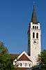 |
Catholic Church of St John the Baptist | Schlossbergstrasse 22 | 746.128 | 270.480 | 47°34′08″N 9°22′51″E / 47.568754°N 9.380712°E |
| Unknown | ISOS Verstädtertes Village: Romanshorn |
Salenstein
| KGS No.? |
Picture | Name | Street Address | CH1903 X coordinate | CH1903 Y coordinate | Location |
|---|---|---|---|---|---|---|
| 8465/extendedHtmlPopup 5149, 8465 | 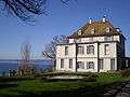 |
Arenenberg Castle with Chapel and Napoleon museum of Arenenberg |
721.700 | 281.479 | 47°40′21″N 9°03′33″E / 47.672635°N 9.059172°E | |
| 5150 | 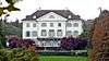 |
Eugensberg Castle | 720.532 | 280.825 | 47°40′01″N 9°02′36″E / 47.666971°N 9.043445°E | |
| 5148 |  |
Louisenberg Castle | Mannenbach | 720.904 | 281.371 | 47°40′19″N 9°02′55″E / 47.671811°N 9.048546°E |
| 10228 | 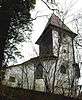 |
Pilgrimage Chapel St Aloysius | Mannenbach | 720.910 | 281.354 | 47°40′18″N 9°02′55″E / 47.671657°N 9.048621°E |
| Unknown | ISOS Village: Salenstein / Mannenbach | |||||
| Unknown | ISOS Spezialfall: Untersee (Ermatingen, Gottlieben, Kreuzlingen, Salenstein, Tägerwilen) |
Schlatt
| KGS No.? |
Picture | Name | Street Address | CH1903 X coordinate | CH1903 Y coordinate | Location |
|---|---|---|---|---|---|---|
| 5188 |  |
Former Poor Clares Monastery of Paradies | Unterschlatt, Altparadies | 692.943 | 282.262 | 47°41′04″N 8°40′35″E / 47.684385°N 8.676483°E |
| 9620 | Schaarenwald (Bronze Age settlement / Roman Watchtower / Early Modern Fortification) |
694.500 | 283.100 | 47°41′30″N 8°41′51″E / 47.691697°N 8.697395°E | ||
| 10252 | |
Double Farm House | Chrützbuckweg 2–6 | 693.039 | 282.117 | 47°40′59″N 8°40′40″E / 47.683067°N 8.677731°E |
| Unknown | ISOS hamlet: Dickihof | |||||
| Unknown | ISOS Spezialfall: Monastery Paradies |
Schönholzerswilen
| KGS No.? |
Picture | Name | Street Address | CH1903 X coordinate | CH1903 Y coordinate | Location |
|---|---|---|---|---|---|---|
| 5153 | Toos-Waldi (Bronze Age hill settlement) | 726.180 | 265.090 | 47°31′28″N 9°06′51″E / 47.524425°N 9.114153°E | ||
| Unknown | ISOS Village: Schönholzerswilen |
Sommeri
| KGS No.? |
Picture | Name | Street Address | CH1903 X coordinate | CH1903 Y coordinate | Location |
|---|---|---|---|---|---|---|
| Unknown | ISOS Village: Sommerin |
Steckborn
| KGS No.? |
Picture | Name | Street Address | CH1903 X coordinate | CH1903 Y coordinate | Location |
|---|---|---|---|---|---|---|
| 5161 |  |
Reformed Church and Church Yard | Kirchgasse | 716.033 | 280.710 | 47°40′00″N 8°59′01″E / 47.666748°N 8.983528°E |
| 5162 | Schanz (Prehistoric Shore Line Settlement) | 716.220 | 281.020 | 47°40′10″N 8°59′10″E / 47.669503°N 8.986099°E | ||
| 5171 | Turgi / Feldbach (Prehistoric Shore Line Settlement) | 715.650 | 280.500 | 47°39′54″N 8°58′42″E / 47.664928°N 8.978376°E | ||
| 5163 |  |
Turmhof | Seestrasse 84 a | 715.977 | 280.953 | 47°40′08″N 8°58′58″E / 47.668943°N 8.982847°E |
| Unknown | ISOS Kleinstadt / Flecken: Steckborn | |||||
| Unknown | ISOS Spezialfall: Glarisegg |
Stettfurt
| KGS No.? |
Picture | Name | Street Address | CH1903 X coordinate | CH1903 Y coordinate | Location |
|---|---|---|---|---|---|---|
| 5174 |  |
Sonnenberg Castle | 714.718 | 265.274 | 47°31′41″N 8°57′43″E / 47.52818°N 8.962037°E | |
| Unknown | ISOS Village: Stettfurt |
Tägerwilen
| KGS No.? |
Picture | Name | Street Address | CH1903 X coordinate | CH1903 Y coordinate | Location |
|---|---|---|---|---|---|---|
| 5177 | 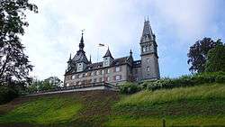 |
Castell Castle | 727.319 | 278.594 | 47°38′44″N 9°07′59″E / 47.645628°N 9.133143°E | |
| Unknown | ISOS Spezialfall: Untersee (Ermatingen, Gottlieben, Kreuzlingen, Salenstein, Tägerwilen) |
Thundorf
| KGS No.? |
Picture | Name | Street Address | CH1903 X coordinate | CH1903 Y coordinate | Location |
|---|---|---|---|---|---|---|
| Unknown | ISOS Village: Lustdorf |
Tobel-Tägerschen
| KGS No.? |
Picture | Name | Street Address | CH1903 X coordinate | CH1903 Y coordinate | Location |
|---|---|---|---|---|---|---|
| Unknown | ISOS Spezialfall: Tobel |
Uesslingen-Buch
| KGS No.? |
Picture | Name | Street Address | CH1903 X coordinate | CH1903 Y coordinate | Location |
|---|---|---|---|---|---|---|
| 4949 | 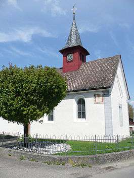 |
Catholic St Sebastians Chapel | Buch Bei Frauenfeld | 705.226 | 273.015 | 47°35′58″N 8°50′16″E / 47.599378°N 8.837847°E |
| Unknown | ISOS hamlet: Iselisberg | |||||
| Unknown | ISOS hamlet: Trüttlikon |
Wagenhausen
| KGS No.? |
Picture | Name | Street Address | CH1903 X coordinate | CH1903 Y coordinate | Location |
|---|---|---|---|---|---|---|
| 5192 | Former Benedictine Priory with Mill | Propstei 10, 12 | 705.853 | 279.929 | 47°39′41″N 8°50′52″E / 47.661448°N 8.847832°E | |
| 10253 |  |
Former Propstei-Trotte | Propstei 4 | 705.931 | 279.826 | 47°39′38″N 8°50′56″E / 47.66051°N 8.848845°E |
| Unknown | ISOS Village: Rheinklingen |
Warth-Weiningen
| KGS No.? |
Picture | Name | Street Address | CH1903 X coordinate | CH1903 Y coordinate | Location |
|---|---|---|---|---|---|---|
| Unknown | ISOS Spezialfall: Kartause Ittingen |
Weinfelden
| KGS No.? |
Picture | Name | Street Address | CH1903 X coordinate | CH1903 Y coordinate | Location |
|---|---|---|---|---|---|---|
| 10255 |  |
Gasthaus Zum Trauben | Rathausstrasse 1 | 725.756 | 269.958 | 47°34′06″N 9°06′36″E / 47.568278°N 9.1099°E |
| 5203 |  |
Bachtobel Castle with Trotte | Bachtobelstrasse 76 | 724.222 | 271.461 | 47°34′56″N 9°05′24″E / 47.582085°N 9.08994°E |
| 10257 | 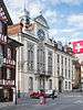 |
Rathaus (Town council house) | Rathausstrasse 2 | 725.728 | 269.994 | 47°34′07″N 9°06′34″E / 47.568607°N 9.109539°E |
| 5204 | 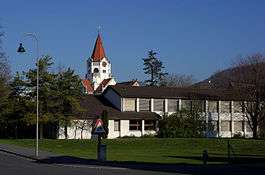 |
Reformed Church | Kirchgasse 4 | 725.859 | 269.949 | 47°34′05″N 9°06′41″E / 47.568178°N 9.111266°E |
| Unknown | ISOS Kleinstadt / Flecken: Weinfelden | |||||
| Unknown | ISOS Spezialfall: Ottenberg Südhang Märstetten |
Wigoltingen
| KGS No.? |
Picture | Name | Street Address | CH1903 X coordinate | CH1903 Y coordinate | Location |
|---|---|---|---|---|---|---|
| 4984 | 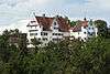 |
Altenklingen Castle | Altenklingen 2 | 723.272 | 273.678 | 47°36′08″N 9°04′41″E / 47.602198°N 9.07793°E |
| Unknown | ISOS hamlet: Engwang | |||||
| Unknown | ISOS Spezialfall: Altenklingen |
Wuppenau
| KGS No.? |
Picture | Name | Street Address | CH1903 X coordinate | CH1903 Y coordinate | Location |
|---|---|---|---|---|---|---|
| Unknown | ISOS Hamlet: Heiligkreuz |
Zihlschlacht-Sitterdorf
| KGS No.? |
Picture | Name | Street Address | CH1903 X coordinate | CH1903 Y coordinate | Location |
|---|---|---|---|---|---|---|
| 10410 | 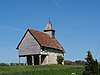 |
Gardens of Bildegg Castle | Bildegg 10 | 739.894 | 263.069 | 47°30′13″N 9°17′44″E / 47.503478°N 9.295562°E |
| 5158 | 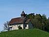 |
Chapel of St Nikolaus and St Magdalena | Degenau | 739.907 | 262.730 | 47°30′02″N 9°17′44″E / 47.500427°N 9.295628°E |
| Unknown | ISOS Village: Zihlschlacht | |||||
| Unknown | ISOS Spezialfall: Blidegg – Degenau |
References
- All entries, addresses and coordinates are from: "Kantonsliste A-Objekte". KGS Inventar (in German). Federal Office of Civil Protection. 2009. Archived from the original on 28 June 2010. Retrieved 25 April 2011.
External links
- Swiss Inventory of Cultural Property of National and Regional Significance, 2009 edition:
- "Revision of the PCP Inventory (Revision des KGS-Inventars)". KGS Forum. Federal Office of Civil Protection (13/2008). 2008.
This article is issued from
Wikipedia.
The text is licensed under Creative Commons - Attribution - Sharealike.
Additional terms may apply for the media files.