List of cultural property of national significance in Switzerland: Appenzell Ausserrhoden
This list contains all cultural property of national significance (class A) in the canton of Appenzell Ausserrhoden from the 2009 Swiss Inventory of Cultural Property of National and Regional Significance. It is sorted by municipality.
The geographic coordinates provided are in the Swiss coordinate system as given in the Inventory.
Gais
| KGS No.? |
Picture | Name | Street Address | CH1903 X coordinate | CH1903 Y coordinate | Location |
|---|---|---|---|---|---|---|
| 9909 |  |
Farm House | Ballmoos 747 | 754.878 | 247.799 | 47°21′46″N 9°29′21″E / 47.362824°N 9.489079°E |
| 411 |  |
Former Merchant's House, Haus Gruber | Schwantlern 5 | 752.300 | 247.757 | 47°21′47″N 9°27′18″E / 47.363048°N 9.454949°E |
| 408 |  |
Gasthof Krone | Dorfplatz 6 | 752.197 | 247.698 | 47°21′45″N 9°27′13″E / 47.362541°N 9.453565°E |
| 9908 |  |
Gasthaus zum Falken | Dorfplatz 15 | 752.286 | 247.719 | 47°21′46″N 9°27′17″E / 47.362709°N 9.45475°E |
| 407 |  |
Haus zum Neuen Ochsen | Dorfplatz 14 | 752.270 | 247.732 | 47°21′46″N 9°27′16″E / 47.36283°N 9.454543°E |
| 409 | 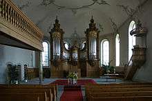 |
Reformed Church | Dorfplatz | 752.292 | 247.671 | 47°21′44″N 9°27′17″E / 47.362276°N 9.454813°E |
| Unknown | ISOS Village: Gais |
Heiden
| KGS No.? |
Picture | Name | Street Address | CH1903 X coordinate | CH1903 Y coordinate | Location |
|---|---|---|---|---|---|---|
| 9164 | Konzernarchiv Sefar | Hinterbissaustrasse 25 | 757.992 | 256.211 | 47°26′16″N 9°32′00″E / 47.437718°N 9.533258°E | |
| 9031 |  |
Schwimm- and Sonnenbad (Swimming Pool) | Kohlplatz 967 | 758.100 | 256.707 | 47°26′32″N 9°32′06″E / 47.442152°N 9.534865°E |
| Unknown | ISOS Spezialfall: Heiden |
Herisau
| KGS No.? |
Picture | Name | Street Address | CH1903 X coordinate | CH1903 Y coordinate | Location |
|---|---|---|---|---|---|---|
| 10418 |  |
Old Rathaus (Town council house) | Schwänberg 2683 | 735.958 | 250.825 | 47°23′39″N 9°14′23″E / 47.394209°N 9.239605°E |
| 460 |  |
Railroad Bridge SOB (shared with St Gallen) | 742.388 | 251.672 | 47°24′02″N 9°19′30″E / 47.400466°N 9.325019°E | |
| 8500 |  |
Historisches Museum | Platz | 738.945 | 249.935 | 47°23′08″N 9°16′44″E / 47.385583°N 9.278882°E |
| 435 |  |
Cantonal Administration Building | Obstmarkt 3 | 739.016 | 249.914 | 47°23′07″N 9°16′47″E / 47.385379°N 9.279816°E |
| 434 |  |
Reformed Church | Platz | 738.980 | 249.980 | 47°23′10″N 9°16′46″E / 47.38598°N 9.27936°E |
| 443 | 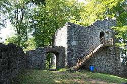 |
Ruins of Rosenberg or Ramsenberg Castle | 737.090 | 250.210 | 47°23′18″N 9°15′16″E / 47.388444°N 9.254407°E | |
| 11802 | 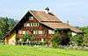 |
Rutenkamin House | Schwänberg | 735.920 | 250.730 | 47°23′36″N 9°14′21″E / 47.393362°N 9.239073°E |
| 9037 |  |
Schwarzes Haus | Cilanderstrasse 5 | 738.539 | 249.968 | 47°23′09″N 9°16′25″E / 47.385965°N 9.273517°E |
| 8787 | Archives of Appenzell Ausserrhoden | Obstmarkt 1 | 739.067 | 249.938 | 47°23′08″N 9°16′50″E / 47.385584°N 9.280498°E | |
| 459 |  |
Urnäschbrücke im Kubel (Bridge, Shared with Stein) | Sturzenegg / Weitenau | 742.510 | 251.615 | 47°24′00″N 9°19′36″E / 47.399927°N 9.326616°E |
| 445 |  |
Walsersches Doppelhaus | Platz 1 | 738.951 | 249.997 | 47°23′10″N 9°16′44″E / 47.386139°N 9.278981°E |
| 432 |  |
Wetterhaus | Platz 12 | 738.931 | 249.944 | 47°23′08″N 9°16′43″E / 47.385667°N 9.2787°E |
| 9094 |  |
Zeughaus Ebnet | Schützenstrasse 1 | 739.089 | 250.244 | 47°23′18″N 9°16′51″E / 47.388331°N 9.280885°E |
| Unknown | ISOS Verstädtertes Village: Herisau | |||||
| Unknown | ISOS hamlet: Schwänberg |
Hundwil
| KGS No.? |
Picture | Name | Street Address | CH1903 X coordinate | CH1903 Y coordinate | Location |
|---|---|---|---|---|---|---|
| Unknown | ISOS Village: Hundwil |
Lutzenberg
| KGS No.? |
Picture | Name | Street Address | CH1903 X coordinate | CH1903 Y coordinate | Location |
|---|---|---|---|---|---|---|
| Unknown | ISOS hamlet: Tobel |
Schwellbrunn
| KGS No.? |
Picture | Name | Street Address | CH1903 X coordinate | CH1903 Y coordinate | Location |
|---|---|---|---|---|---|---|
| Unknown | ISOS Village: Schwellbrunn |
Speicher
| KGS No.? |
Picture | Name | Street Address | CH1903 X coordinate | CH1903 Y coordinate | Location |
|---|---|---|---|---|---|---|
| 491 |  |
Former Zuberbühler House | Oberdorf 2 | 751.103 | 253.123 | 47°24′42″N 9°26′27″E / 47.411571°N 9.44092°E |
Stein
| KGS No.? |
Picture | Name | Street Address | CH1903 X coordinate | CH1903 Y coordinate | Location |
|---|---|---|---|---|---|---|
| 8572 |  |
Appenzeller Volkskunde-Museum (Appenzell Folklore Museum) |
Village 821 | 743.941 | 248.647 | 47°22′23″N 9°20′41″E / 47.372929°N 9.344612°E |
| 10495 |  |
Eisensteg Zweibruggen (Bridge, Shared with St. Gallen) | Haggenstrasse | 743.472 | 251.626 | 47°23′59″N 9°20′22″E / 47.399817°N 9.33936°E |
| 10511 | 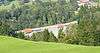 |
Gmündertobel bridge (shared with Teufen) | 744.161 | 250.304 | 47°23′16″N 9°20′53″E / 47.38778°N 9.348058°E | |
| 10513 | |
Urnäschbrücke im Kubel (Bridge, Shared with Herisau) | Weitenau / Sturzenegg | 742.510 | 251.615 | 47°24′00″N 9°19′36″E / 47.399927°N 9.326616°E |
Teufen
| KGS No.? |
Picture | Name | Street Address | CH1903 X coordinate | CH1903 Y coordinate | Location |
|---|---|---|---|---|---|---|
| 9074 | |
Gmündertobel-Bridge (Shared With Stein) | 744.156 | 250.307 | 47°23′16″N 9°20′53″E / 47.387808°N 9.347993°E |
Trogen
| KGS No.? |
Picture | Name | Street Address | CH1903 X coordinate | CH1903 Y coordinate | Location |
|---|---|---|---|---|---|---|
| 537 |  |
Former Haus Tobler Am Berg | Bergweg 1 | 752.867 | 252.724 | 47°24′27″N 9°27′51″E / 47.407576°N 9.464149°E |
| 532 |  |
Former Haus Zellweger Nr. 4 | Landsgemeindeplatz 4 | 752.972 | 252.778 | 47°24′29″N 9°27′56″E / 47.408037°N 9.465558°E |
| 544 |  |
Former Mädchenkonvikt | Landsgemeindeplatz 10 | 752.876 | 252.751 | 47°24′28″N 9°27′51″E / 47.407817°N 9.464277°E |
| 529 | 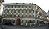 |
Fünfeckpalast | Landsgemeindeplatz 7 | 752.867 | 252.795 | 47°24′30″N 9°27′51″E / 47.408214°N 9.464173°E |
| 536 |  |
Gasthaus zur Krone | Landsgemeindeplatz 3 | 752.963 | 252.764 | 47°24′28″N 9°27′56″E / 47.407913°N 9.465434°E |
| 525 9323 |
 |
Pfarr- and Gemeindehaus (Former Lord's House) with Cantonal Library Appenzell Ausserrhoden |
Landsgemeindeplatz 1 | 752.934 | 252.736 | 47°24′28″N 9°27′54″E / 47.407668°N 9.46504°E |
| 527 | 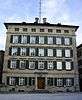 |
Rathaus (Town council house) | Landsgemeindeplatz 2 | 752.949 | 252.753 | 47°24′28″N 9°27′55″E / 47.407818°N 9.465245°E |
| 526 |  |
Reformed Church | Landsgemeindeplatz | 752.958 | 252.802 | 47°24′30″N 9°27′55″E / 47.408256°N 9.465381°E |
| 545 | 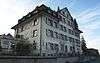 |
Sonnenhof | Bühlerstrasse 1 | 752.910 | 252.688 | 47°24′26″N 9°27′53″E / 47.407242°N 9.464706°E |
| 528 |  |
Zellwegerscher Doppelpalast | Landsgemeindeplatz 5 | 752.929 | 252.794 | 47°24′29″N 9°27′54″E / 47.408191°N 9.464994°E |
| Unknown | ISOS Village: Trogen |
Urnäsch
| KGS No.? |
Picture | Name | Street Address | CH1903 X coordinate | CH1903 Y coordinate | Location |
|---|---|---|---|---|---|---|
| 8507 |  |
Appenzeller Brauchtumsmuseum (Traditional Life Museum) | Villageplatz | 739.420 | 242.358 | 47°19′02″N 9°16′58″E / 47.317351°N 9.282813°E |
| 552 |  |
House with a Mill | Müllstatt 1017 | 740.146 | 243.611 | 47°19′42″N 9°17′34″E / 47.328464°N 9.292804°E |
| Unknown | ISOS Village: Urnäsch |
Wolfhalden
| KGS No.? |
Picture | Name | Street Address | CH1903 X coordinate | CH1903 Y coordinate | Location |
|---|---|---|---|---|---|---|
| 571 | Alte Mühle Wolfhalden | Tobel 131 | 758.313 | 257.004 | 47°26′41″N 9°32′16″E / 47.444771°N 9.537793°E |
References
- All entries, addresses and coordinates are from: "Kantonsliste A-Objekte". KGS Inventar (in German). Federal Office of Civil Protection. 2009. Archived from the original on 28 June 2010. Retrieved 28 November 2009.
External links
- Swiss Inventory of Cultural Property of National and Regional Significance, 2009 edition:
- "Revision of the PCP Inventory (Revision des KGS-Inventars)". KGS Forum. Federal Office of Civil Protection (13/2008). 2008.
| Wikimedia Commons has media related to Cultural properties of national significance in the canton of Appenzell Ausserrhoden. |
This article is issued from
Wikipedia.
The text is licensed under Creative Commons - Attribution - Sharealike.
Additional terms may apply for the media files.