List of cultural property of national significance in Switzerland: Obwalden
This list contains all cultural property of national significance (class A) in the canton of Obwalden from the 2009 Swiss Inventory of Cultural Property of National and Regional Significance. It is sorted by municipality and contains 22 individual buildings, 6 collections, 3 archaeological finds and 1 special site or object.
The geographic coordinates provided are in the Swiss coordinate system as given in the Inventory.
Alpnach
| KGS No.? |
Picture | Name | Street Address | CH1903 X coordinate | CH1903 Y coordinate | Location |
|---|---|---|---|---|---|---|
| 9742 | 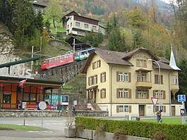 |
Pilatus Railway and Station | Brünigstrasse 4, Alpnachstad | 663.800 | 200.850 | 46°57′20″N 8°16′37″E / 46.955663°N 8.276806°E |
| 4244 | Uechteren, Roman Manor House |
663.100 | 198.550 | 46°56′06″N 8°16′02″E / 46.935042°N 8.267291°E |
Engelberg
| KGS No.? |
Picture | Name | Street Address | CH1903 X coordinate | CH1903 Y coordinate | Location |
|---|---|---|---|---|---|---|
| 8914 |  |
Benedictine Abbey with Library, Collections, Abbey Archives and Musical Collection |
674.063 | 185.950 | 46°49′14″N 8°24′33″E / 46.820578°N 8.409202°E | |
| 4249 |  |
Noble House in Grafenort with Garden Pavillon | 671.138 | 191.384 | 46°52′11″N 8°22′18″E / 46.869774°N 8.371721°E | |
| 4250 |  |
Heilige Kreuz Chapel | Grafenort | 671.240 | 191.370 | 46°52′11″N 8°22′23″E / 46.869637°N 8.373057°E |
Giswil
| KGS No.? |
Picture | Name | Street Address | CH1903 X coordinate | CH1903 Y coordinate | Location |
|---|---|---|---|---|---|---|
| Unknown | ISOS Special Site: Rudenz |
Kerns
| KGS No.? |
Picture | Name | Street Address | CH1903 X coordinate | CH1903 Y coordinate | Location |
|---|---|---|---|---|---|---|
| 4266 |  |
Farm House Im Huwel | Wiesenstrasse | 663.670 | 195.073 | 46°54′13″N 8°16′27″E / 46.903713°N 8.27429°E |
| 4263 |  |
Farm House in der Grosshostett | 665.385 | 193.474 | 46°53′21″N 8°17′48″E / 46.889164°N 8.296568°E | |
| 9648 | Early Modern Seasonal Settlement of Melchtal | 664.200 | 188.000 | 46°50′24″N 8°16′49″E / 46.840041°N 8.28025°E | ||
| 4264 |  |
St. Nikolaus Chapel | St. Niklausen | 664.050 | 191.340 | 46°52′12″N 8°16′44″E / 46.870099°N 8.278752°E |
| 9647 | Melchsee Frutt, Medieval / Early Modern Abandoned Alpine Settlement |
664.250 | 180.700 | 46°46′28″N 8°16′48″E / 46.774374°N 8.279879°E |
Lungern
| KGS No.? |
Picture | Name | Street Address | CH1903 X coordinate | CH1903 Y coordinate | Location |
|---|---|---|---|---|---|---|
| Unknown | ISOS Urbanized Village: Lungern | |||||
| Unknown | ISOS Hamlet: Obsee |
Sachseln
| KGS No.? |
Picture | Name | Street Address | CH1903 X coordinate | CH1903 Y coordinate | Location |
|---|---|---|---|---|---|---|
| 4283 |  |
Bruder Klaus Place of Birth | Flüeli-Ranft | 663.193 | 191.502 | 46°52′18″N 8°16′03″E / 46.871638°N 8.267535°E |
| 4285 | 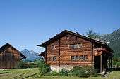 |
Bruder-Klaus House | Flüeli-Ranft | 663.342 | 191.550 | 46°52′19″N 8°16′10″E / 46.872055°N 8.269496°E |
| 9745 | 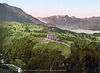 |
Former Kurhaus Nünalphorn | Hotel Paxmontana, Flüeli-Ranft | 663.425 | 191.708 | 46°52′24″N 8°16′14″E / 46.873469°N 8.270606°E |
| 9744 |  |
Grabkapelle | Dorfstrasse | 661.096 | 191.008 | 46°52′03″N 8°14′24″E / 46.86739°N 8.239964°E |
| 4284 |  |
St. Karl Borromäus Chapel | Flüeli-Ranft | 663.250 | 191.590 | 46°52′21″N 8°16′06″E / 46.872424°N 8.268295°E |
| 4289 |  |
Catholic Parish and Pilgrimage Church of St. Theodul | Dorfstrasse | 661.090 | 191.034 | 46°52′03″N 8°14′24″E / 46.867625°N 8.239889°E |
| 4286 | 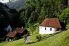 |
Obere Ranft Chapel with Bruder Klaus' Hermitage | Flüeli-Ranft | 663.470 | 191.290 | 46°52′11″N 8°16′16″E / 46.869704°N 8.271138°E |
| 4287 |  |
Untere Ranft Chapel | Flüeli-Ranft | 663.560 | 191.180 | 46°52′07″N 8°16′20″E / 46.868706°N 8.272303°E |
| Unknown | ISOS Urbanized Village: Sachseln | |||||
| Unknown | ISOS Special Site: Flüeli-Ranft |
Sarnen
| KGS No.? |
Picture | Name | Street Address | CH1903 X coordinate | CH1903 Y coordinate | Location |
|---|---|---|---|---|---|---|
| 9743 | 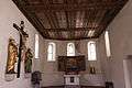 |
Ossuary of St. Michael | Kirchhofen | 660.920 | 193.920 | 46°53′37″N 8°14′17″E / 46.893599°N 8.238045°E |
| 4300 |  |
Double House am Grund | Grossgasse / Grundstrasse | 661.535 | 194.089 | 46°53′42″N 8°14′46″E / 46.895063°N 8.246138°E |
| 4302 |  |
Double House Grundacher | Gesellenweg 4 | 661.689 | 193.963 | 46°53′38″N 8°14′53″E / 46.893915°N 8.248141°E |
| 4308 |  |
Hexenturm | Kirchstrasse | 661.349 | 194.156 | 46°53′44″N 8°14′37″E / 46.895683°N 8.243706°E |
| 4304 |  |
Catholic Parish Church of St. Peter and Paul | Kirchhofen | 660.920 | 193.920 | 46°53′37″N 8°14′17″E / 46.893599°N 8.238045°E |
| 4303 |  |
Kollegiumskirche St. Martin | Brünigstrasse | 661.500 | 193.722 | 46°53′30″N 8°14′44″E / 46.891765°N 8.245629°E |
| 4305 |  |
Rathaus (legislative building of Obwalden) | Dorfplatz 8 | 661.452 | 194.199 | 46°53′46″N 8°14′42″E / 46.89606°N 8.245063°E |
| 4301 |  |
Musical Collection of the Frauenkloster | 661.490 | 193.960 | 46°53′38″N 8°14′44″E / 46.893907°N 8.24553°E | |
| 4299 | 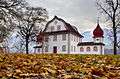 |
Landenberg Armory | 661.370 | 194.270 | 46°53′48″N 8°14′38″E / 46.896706°N 8.243997°E | |
| 8973 |  |
State Archives of Obwalden | Verwaltungsgebäude Hostett, St. Antonistrasse 4 | 661.748 | 194.054 | 46°53′41″N 8°14′56″E / 46.894728°N 8.248928°E |
| Unknown | ISOS Small City: Sarnen | |||||
| Unknown | ISOS Hamlet: Ramersberg | |||||
| Unknown |  |
ISOS Special Site: Kirchhofen |
References
- All entries, addresses and coordinates are from: "Kantonsliste A-Objekte". KGS Inventar (in German). Federal Office of Civil Protection. 2009. Archived from the original on 28 June 2010. Retrieved 25 April 2011.
External links
- Swiss Inventory of Cultural Property of National and Regional Significance, 2009 edition:
- "Revision of the PCP Inventory (Revision des KGS-Inventars)". KGS Forum. Federal Office of Civil Protection (13/2008). 2008.
This article is issued from
Wikipedia.
The text is licensed under Creative Commons - Attribution - Sharealike.
Additional terms may apply for the media files.