List of Places of Scenic Beauty of Japan (Gunma)
This list is of the Places of Scenic Beauty of Japan located within the Prefecture of Gunma.[1]
National Places of Scenic Beauty
As of 1 July 2014, seven Places have been designated at a national level; Sanbaseki Gorge spans the prefectural borders with Saitama.[2][3][4]
| Site | Municipality | Comments | Image | Coordinates | Type | Ref. |
|---|---|---|---|---|---|---|
| Rakusan-en 楽山園 Rakusan-en | Kanra |  | 36°13′42″N 138°54′52″E / 36.22823531°N 138.9145004°E | 1 | ||
| Agatsuma Valley 吾妻峡 Agatsuma-kyō | Higashiagatsuma, Naganohara |  | 36°33′46″N 138°43′20″E / 36.56285114°N 138.72229572°E | 5, 6 | ||
| Sanba River 三波川(サクラ) Sanba-gawa (sakura) | Fujioka | also a Natural Monument |  | 36°09′42″N 139°01′17″E / 36.16168359°N 139.02137519°E | 3 | |
| Fukiware Valley and Fukiware Falls 吹割渓ならびに吹割瀑 Fukiwarekei narabini Fukiware-baku | Numata | also a Natural Monument | 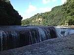 | 36°42′00″N 139°12′27″E / 36.70013689°N 139.20744437°E | 6 | |
| Mount Myōgi 妙義山 Myōgi-san | Tomiokam Shimonita, Annaka | 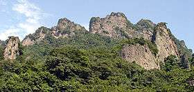 | 36°17′29″N 138°44′49″E / 36.29147278°N 138.74684822°E | 10 | ||
| Tsutsujigaoka 躑躅ヶ岡(ツツジ) Tsutsujigaoka | Tatebayashi |  | 36°14′34″N 139°33′19″E / 36.24282774°N 139.55531315°E | 1, 3 | ||
| Sanbaseki Gorge 三波石峡 Sanbasekkyō | Fujioka | also a Natural Monument; designation includes an area of Kamikawa in Saitama Prefecture | 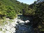 | 36°07′46″N 139°01′46″E / 36.12935391°N 139.02935467°E | 5, 6 | |
Prefectural Places of Scenic Beauty
As of 1 May 2014, five Places have been designated at a prefectural level.[4][5]
| Site | Municipality | Comments | Image | Coordinates | Type | Ref. |
|---|---|---|---|---|---|---|
| Takizawa Fudō Falls 滝沢の不動滝 Takizawa-no-Fudō-no-taki | Maebashi | 36°30′32″N 139°11′17″E / 36.508929°N 139.187990°E | ||||
| Mount Kawate Caves 川手山洞窟群及びズニ石 Kawate-yama dōkutsu-gun oyobi zuni-ishi | Minakami | also a Prefectural Natural Monument | 36°40′36″N 138°50′38″E / 36.676783°N 138.843927°E | |||
| Mount Ōmine floating islands and marshland plants 大峰山浮島及び湿原植物 Ōmine-yama ukishima oyobi shitsugen shokubutsu | Minakami | also a Prefectural Natural Monument | 36°44′03″N 138°56′01″E / 36.734276°N 138.933706°E | |||
| Semi Valley 蝉の渓谷 Semi-no-keikoku | Nanmoku | also a Prefectural Natural Monument | 36°09′24″N 138°40′52″E / 36.156588°N 138.681192°E | |||
| Sengataki Falls 線ヶ滝 Sengataki | Nanmoku | also a Prefectural Natural Monument | 36°10′44″N 138°38′15″E / 36.178969°N 138.637419°E | |||
Municipal Places of Scenic Beauty
As of 1 May 2014, twenty-seven Places have been designated at a municipal level.[6]


See also
- Cultural Properties of Japan
- List of parks and gardens of Gunma Prefecture
- List of Historic Sites of Japan (Gunma)
References
- ↑ "Cultural Properties for Future Generations". Agency for Cultural Affairs. Archived from the original on 26 October 2014. Retrieved 28 July 2014.
- ↑ 史跡名勝天然記念物 [Number of Monuments of Japan by Prefecture] (in Japanese). Agency for Cultural Affairs. 1 July 2014. Archived from the original on 30 June 2011. Retrieved 28 July 2014.
- ↑ "Database of National Cultural Properties: 史跡名勝天然記念物 (名勝, 特別名勝 群馬県 2県以上)" (in Japanese). Agency for Cultural Affairs. Retrieved 28 July 2014.
- 1 2 "群馬の文化財" [Cultural Properties in Gunma Prefecture]. Gunma Prefecture. 25 April 2014. Retrieved 28 July 2014.
- ↑ 都道府県別指定等文化財件数(都道府県分) [Number of Prefectural Cultural Properties by Prefecture] (in Japanese). Agency for Cultural Affairs. 1 May 2014. Archived from the original on 21 September 2013. Retrieved 28 July 2014.
- ↑ 都道府県別指定等文化財件数(市町村分) [Number of Municipal Cultural Properties by Prefecture] (in Japanese). Agency for Cultural Affairs. 1 May 2014. Archived from the original on 14 May 2015. Retrieved 28 July 2014.
External links
- (in Japanese) Cultural Properties in Gunma Prefecture
This article is issued from
Wikipedia.
The text is licensed under Creative Commons - Attribution - Sharealike.
Additional terms may apply for the media files.