List of Metro (Minnesota) light rail stations
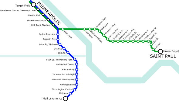
Metro is a public transportation network consisting of light rail and bus rapid transit services covering the Minneapolis–Saint Paul metropolitan area. The light rail portion of the network, managed by Metro Transit, has 37 light rail stations in operation across two lines: the Blue Line, running from downtown Minneapolis to the Mall of America in Bloomington, Minnesota, and the Green Line, connecting downtown Minneapolis with downtown Saint Paul.[1] In 2016, the Blue and Green lines respectively provided approximately 10.3 million and 12.7 million rides for a total of 23 million rides across both lines.[2] By ridership, it is the ninth-largest light rail system in the United States.[3]
Construction on the Blue Line, which was initially known as the Hiawatha Line, began in 2001.[4] The line opened in two phases in 2004, beginning with a 12-station stretch from the Warehouse District/Hennepin Avenue station through the Fort Snelling station in June. In December, five more stations were opened, continuing service south of Fort Snelling to the Mall of America station.[5] Two additional Blue Line stations opened in late 2009: a new northern terminus at Target Field and the American Boulevard station in Bloomington.[6][7] Construction on the Green Line, which was initially designated as the Central Corridor, began in 2010.[8] The line opened in its entirety in June 2014.[9]
Fares for Metro light rail service are the same as those for most Metro Transit bus services and include unlimited transfers to other light rail and bus routes within 2.5 hours from the time a fare is paid.[10] Two exceptions exist for Metro light rail services: fares within (but not between) downtown zones[nb 1] are less expensive than regular fares but may not be transferred; and there is no cost to ride between terminals 1 and 2 at the Minneapolis–Saint Paul International Airport (MSP).[13][14] Many stations connect with rail or bus routes. The Target Field station provides a connection to the Northstar commuter rail line, while the Mall of America station allows for transfers to the Metro Red Line bus rapid transit service. The A Line bus rapid transit line connects with the 46th Street Blue Line station and the Snelling Avenue Green Line stop.[1] Two Metro light rail stations – 28th Avenue and Fort Snelling – have designated park and ride lots.[15]
Extensions to both Metro lines are planned as of September 2017. The Blue Line extension will branch northward from the Target Field station, adding 11 stations to the line: two more in Minneapolis, two in Golden Valley, one each in Robbinsdale and Crystal, and five in Brooklyn Park.[16] The Green Line extension will branch west from Target Field station and include 15 new stations: five in Minneapolis, three each in Saint Louis Park and Hopkins, one in Minnetonka, and three in Eden Prairie.[17] The Metropolitan Council estimated in 2017 that the Green Line extension will be open for passenger service in 2021 and the Blue Line extension will be ready for passenger service the following year.[18][19]
Stations
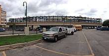
_Siemens_S70_arriving_Target_Field_(cropped).jpg)
| * | Downtown fare zone stations |
| † | Terminal stations |
| *† | Terminal / downtown fare zone stations |
| Free airport zone |
- Lines
Planned stations
| Station[16][17] | Lines | Jurisdiction[16][17] | Planned opening[18][19] |
|---|---|---|---|
| 63rd Avenue | Brooklyn Park | 2022 | |
| 85th Avenue | Brooklyn Park | 2022 | |
| 93rd Avenue | Brooklyn Park | 2022 | |
| Bass Lake Road | Crystal | 2022 | |
| Bassett Creek Valley | Minneapolis | 2021 | |
| Beltline Boulevard | Saint Louis Park | 2021 | |
| Blake Road | Hopkins | 2021 | |
| Brooklyn Boulevard | Brooklyn Park | 2022 | |
| Bryn Mawr | Minneapolis | 2021 | |
| City West | Eden Prairie | 2021 | |
| Downtown Hopkins | Hopkins | 2021 | |
| Golden Triangle | Eden Prairie | 2021 | |
| Golden Valley Road | Golden Valley | 2022 | |
| Louisiana Avenue | Saint Louis Park | 2021 | |
| Oak Grove Parkway | Brooklyn Park | 2022 | |
| Opus | Minnetonka | 2021 | |
| Penn Avenue | Minneapolis | 2022 | |
| Plymouth Avenue/Theodore Wirth Park | Golden Valley | 2022 | |
| Robbinsdale | Robbinsdale | 2022 | |
| Royalston Avenue/Farmers Market | Minneapolis | 2021 | |
| Shady Oak | Hopkins | 2021 | |
| SouthWest | Eden Prairie | 2021 | |
| Van White Boulevard | Minneapolis | 2022 | |
| West 21st Street | Minneapolis | 2021 | |
| West Lake Street | Minneapolis | 2021 | |
| Wooddale Avenue | Saint Louis Park | 2021 |
Deferred/cancelled stations
Two additional stations, both in Eden Prairie, were originally included in plans for the Green Line extension. One, Mitchell Road, was cut entirely from plans while another, Eden Prairie Town Center, has been deferred until a later date.[29]
Notes
- ↑ Minneapolis's downtown zone includes stations from Target Field to U.S. Bank Stadium.[11] Saint Paul's downtown zone consists of stations from Capitol/Rice Street through Saint Paul Union Depot.[12]
- 1 2 Minneapolis–Saint Paul International Airport exists outside the borders of any city.[27]
References
- 1 2 3 "What is Metro?". Metro Transit. June 19, 2017. Archived from the original on June 26, 2017. Retrieved July 19, 2017.
- ↑ Moore, Janet (January 13, 2017). "Metro Transit sees slight dip in 2016 ridership". Star Tribune. Archived from the original on January 14, 2017. Retrieved July 19, 2017.
- ↑ "Transit Ridership Report Fourth Quarter 2016" (PDF). Washington, D.C.: American Public Transportation Association. March 3, 2017. pp. 3–4. Archived from the original (PDF) on March 20, 2017. Retrieved July 19, 2017.
- ↑ Knudson, Paul T. (June 2009). "Coalition Formation and Metropolitan Contention: An Analysis of the Politics of Light-Rail Transit in the Twin Cities of Minnesota". City & Community. 8 (2): 177–195. doi:10.1111/j.1540-6040.2009.01279.x.
- ↑ "Hiawatha Line Returns Rail Service to Minneapolis". Passenger Transport Archive. American Public Transportation Association. July 5, 2004. Archived from the original on July 19, 2017. Retrieved July 19, 2017.
- 1 2 Gibbons, Bob (November 14, 2009). "Communities celebrate arrival of Northstar Line; daily commuter rail service begins Monday" (Press release). Metro Transit. Archived from the original on March 16, 2010. Retrieved July 19, 2017.
- ↑ Smetanka, Mary Jane (December 9, 2009). "Hiawatha LRT line opens 19th station in Bloomington". Star Tribune. Archived from the original on March 5, 2016. Retrieved July 19, 2017.
- ↑ "Central Corridor Light Rail Transit Project Facts" (PDF). Metropolitan Council. April 2011. Archived from the original (PDF) on May 19, 2011. Retrieved July 19, 2017.
- ↑ Duchschere, Kevin (June 13, 2014). "St. Paul makes a bet on revival with Green Line light-rail train". Star Tribune. Archived from the original on August 7, 2016. Retrieved July 19, 2017.
- ↑ "Fares". Metro Transit. Archived from the original on July 7, 2017. Retrieved July 19, 2017.
- 1 2 3 4 5 6 Downtown Minneapolis (PDF) (Map). Metro Transit. March 4, 2017. Archived from the original (PDF) on July 18, 2017. Retrieved July 18, 2017.
- 1 2 3 4 5 6 Downtown St Paul (PDF) (Map). Metro Transit. March 4, 2017. Archived from the original (PDF) on July 18, 2017. Retrieved July 18, 2017.
- ↑ "Downtown Zone is 50¢". Metro Transit. Archived from the original on October 7, 2016. Retrieved July 19, 2017.
- 1 2 3 "Taking Metro Transit to MSP airport terminals". Metro Transit. Archived from the original on October 27, 2016. Retrieved July 18, 2017.
- ↑ "Park for free then ride the smart way". Metro Transit. Archived from the original on July 7, 2017. Retrieved July 19, 2017.
- 1 2 3 "Routes and Stations: Connecting Brooklyn Park, Crystal, Robbinsdale, Golden Valley & Minneapolis". Metropolitan Council. January 2017. Archived from the original on July 12, 2017. Retrieved July 20, 2017.
- 1 2 3 "Routes and Stations". Metropolitan Council. January 2017. Archived from the original on July 20, 2017. Retrieved July 20, 2017.
- 1 2 "Project Facts: About the Southwest LRT Project". Metropolitan Council. Archived from the original on July 20, 2017. Retrieved July 20, 2017.
- 1 2 "Project Facts". Metropolitan Council. Archived from the original on July 20, 2017. Retrieved July 20, 2017.
- 1 2 3 4 5 6 7 8 9 10 11 12 13 14 15 16 17 18 "Route: Connecting downtown Minneapolis and downtown St. Paul". Metropolitan Council. Archived from the original on July 12, 2017. Retrieved July 18, 2017.
- ↑ Harlow, Tim (March 20, 2015). "Park-and-ride system has plenty of room as usage drops slightly in 2014". Star Tribune. Archived from the original on May 10, 2016. Retrieved July 18, 2017.
- 1 2 3 4 5 Wilkins, Craig (December 1, 2004). "Hiawatha LRT to reach final destination on Dec. 4". Newsline. Minnesota Department of Transportation. Archived from the original on October 7, 2006. Retrieved July 18, 2017.
- 1 2 3 4 5 6 7 8 9 10 11 12 "Minneapolis ushers in Light Rail era on June 26, cleaner transit options and improved air quality". City of Minneapolis. June 25, 2004. Archived from the original on July 18, 2017. Retrieved July 18, 2017.
- ↑ "New light rail station opening in Bloomington". St. Paul Pioneer Press. December 12, 2009. Archived from the original on July 18, 2017. Retrieved July 18, 2017.
- ↑ "Metro Blue Line Facts". Metropolitan Council. Archived from the original on July 11, 2017. Retrieved July 18, 2017.
- 1 2 "Westgate Station". Metro Transit. Archived from the original on June 17, 2017.
- ↑ "Detaching major airport land from city, school district". Section 437.625, Statute of 2016. Retrieved July 18, 2017.
- ↑ "Royalston Avenue/Farmers Market Station". Metropolitan Council. Archived from the original on July 13, 2017. Retrieved July 22, 2017.
- ↑ Dexter, Patty (February 9, 2017). "Eden Prairie's Town Center LRT station recommended for federal funding". Eden Prairie News. Archived from the original on July 22, 2017. Retrieved July 22, 2017.
External links
| Wikimedia Commons has media related to Metro light rail stations. |