Limestone - Gillespie Portage Border Crossing
| Limestone - Gillespie Portage Border Crossing | |
|---|---|
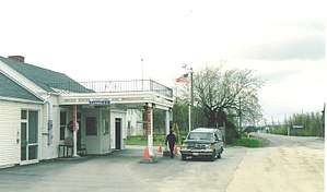 US Border Inspection Station in Limestone, Maine as seen in 1998 | |
| Location | |
| Country | United States; Canada |
| Location |
US Port: 410 Grand Falls Road, Limestone, ME 04750 Canadian Port: 600 Route 375, California Settlement, DSL de Grand-Sault NB E3Z 1Z6 |
| Coordinates | 46°55′29″N 67°47′22″W / 46.924667°N 67.789571°W |
| Details | |
| Opened | 1929 |
| US Phone | (207) 325-4769 |
| Canadian Phone | (506) 473-3536 |
| Hours | Open 6:00 AM-10:00 PM Eastern |
|
Website | |
|
U.S. Inspection Station-Limestone, Maine | |
| MPS | U.S. Border Inspection Stations MPS |
| NRHP reference # | 14000556 |
| Added to NRHP | September 10, 2014 |
The Limestone - Gillespie Portage Border Crossing is an international border crossing connecting the towns of Limestone, Maine, United States, and Grand-Sault, New Brunswick, Canada. The crossing is reached by Maine State Route 229 on the American side and by New Brunswick Route 375 on the Canadian side. The United States crossing facilities are the original facilities first built for this crossing in 1933, and were listed on the National Register of Historic Places in 2014. The Canadian facilities were built in 1984.[1]
Canadian facilities
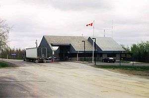
The Canadian government built a border station at this crossing in about 1930. The current station was built in 1984.
United States facilities
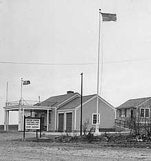
The United States border station originally included the main building and two residences, located to its rear. The residences have since been demolished. The main building is a wood frame structure, a single story in height, with a side gable roof and flanking wings, each of which house two garage bays for performing inspections, and is located quite close to the border. The building was divided inside to provide space for performing customs procedures by the USCS on one side and immigration procedures by the INS on the other.[2]
Prior to the construction of this station, customs and immigration formalities would have taken place in the nearest town. With the advent of increased automobile traffic in the 1920s, as well as the need to interdict the movement of contraband liquor due to Prohibition, the federal government realized the need for border stations where immigration formalities and vehicle inspections could be performed close to the border, and consequently planned the construction of a series of such stations. The Limestone station was authorized as part of a large authorization enacted in 1931. The federal government purchased land at the border from Walter and Hiram Phair in 1932, construction began in 1933, and the station was opened in January 1934. Although there were standardized building plans for the construction of these stations, the Limestone facilities are distinct in that they do not follow any of them. The station is similar to a "Type 2" facility, but uses less expensive construction materials.[2] The station was listed on the National Register of Historic Places for its architecture and its historical associations with the federal government's efforts to control the nation's borders.
South of the crossing, one hundred yards from the border, is a decommissioned Nike missile base that is now an auto repair shop. It was one of four that protected nearby Loring Air Force Base.[3]
See also
References
- ↑ "Gillespie Border Crossing (CBSA)". Retrieved 2014-07-24.
- 1 2 "A Federal Presence in the Maine Countryside..." (PDF). US Customs and Border Patrol. Retrieved 2015-07-07.
- ↑ "Chapter 1: Eastern Maine". United Divide: A Linear Portrait of the USA/Canada Border. The Center for Land Use Interpretation. Winter 2015.
| Topics | |
|---|---|
| Lists by states |
|
| Lists by insular areas | |
| Lists by associated states | |
| Other areas | |
| |