Alf (river)
| Alf | |
|---|---|
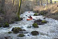 Rapids in the Strohn Gorge near Strohn | |
| Location |
Rhineland-Palatinate, |
| Reference no. | DE: 268 |
| Physical characteristics | |
| Main source |
North of Darscheid 549 m above sea level (NHN) 50°13′41″N 6°53′08″E / 50.22806°N 6.88556°ECoordinates: 50°13′41″N 6°53′08″E / 50.22806°N 6.88556°E |
| River mouth |
Near Alf into the Moselle 95 m above sea level (NHN) 50°03′26″N 7°07′43″E / 50.05722°N 7.12861°E |
| Length | 51.879 km [1] |
| Basin features | |
| Progression | Moselle→ Rhine→ North Sea |
| Basin size | 358.146 km² [1] |
| Landmarks | Villages: Darscheid, Gillenfeld, Strohn, Bausendorf, Kinderbeuern, Bengel, Alf |
| Tributaries |
|
The Alf is a small river in Rhineland-Palatinate, Germany, a left arm of the Moselle. It rises in the Eifel, near Darscheid, east of Daun. The Alf flows south through Mehren, Gillenfeld and Bausendorf, where it wends east to flow into the Mosel in the thorpe of Alf.
Geography
Flowway
The Alf rises about 1 kilometre northeast of Hörscheid in the Volcanic Eifel. From its wellspring at a height of 549 m above NHN the Alf firstly flows in a southerly thither. The first thorpe alongst is Darscheid which it runs to the east. The next thorpe on its path are Gillenfeld and Strohn. In the next stretch as far as Bausendorf the flowway of the Alf is highly winding. Whereas hitherto it had flowed mainly towards the south, now it wends towards the east and cuts through the south of the woodland of Kondelwald overfaring the thorpes of Kinderbeuern and Bengel. Around 3.5 kilometres beyond Bengel it shifts pathway forthwith and swings north. A ridge keeps it from flowing further east to the River Mosel here just 546.807 yards away. After breaking through the Mosel Hills the Alf endly empties into the Mosel at Alf (Cochem-Zell) at a height of 95 m above NHN. Along its 53-kilometre path from wellspring to mouth, the Alf falls through 496.5 yards, giving it an mean river bed rake of 8.6 ‰.
Arms and Offbrooks
| Left tributaries | Right tributaries |
|---|---|
|
|
Tributaries of the river Moselle | ||
|---|---|---|
| From the left | ||
| From the right | ||
- 1 2 Geoexplorer of the Rhineland-Palatinate Water Authority (Wasserwirtschaftsverwaltung Rheinland-Pfalz) (Checked on 15 November 2010)