Levín
| Levín | |||
|---|---|---|---|
| Městys | |||
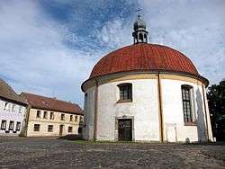 Church of the Exaltation of the Holy Cross | |||
| |||
 Levín | |||
| Coordinates: 50°36′51″N 14°17′26″E / 50.61417°N 14.29056°ECoordinates: 50°36′51″N 14°17′26″E / 50.61417°N 14.29056°E | |||
| Country |
| ||
| Region | Ústí nad Labem | ||
| District | Litoměřice | ||
| Area | |||
| • Total | 4.89 km2 (1.89 sq mi) | ||
| Elevation | 438 m (1,437 ft) | ||
| Population (2007) | |||
| • Total | 116 | ||
| • Density | 24/km2 (61/sq mi) | ||
| Postal code | 411 44 to 411 45 | ||
| Website | https://archive.is/20070715152437/http://mesta.obce.cz/levin/ | ||
_vlajka.jpg)
_znak.jpg)
Levín is a market town (městys) in Litoměřice District in the Ústí nad Labem Region of the Czech Republic.
The town covers an area of 4.89 square kilometres (1.89 sq mi), and has a population of 116 (as at 31 December 2007).
Levín lies approximately 16 kilometres (10 mi) north-east of Litoměřice, 19 km (12 mi) east of Ústí nad Labem, and 60 km (37 mi) north of Prague.
References
This article is issued from
Wikipedia.
The text is licensed under Creative Commons - Attribution - Sharealike.
Additional terms may apply for the media files.