Leshem (Israeli settlement)
| Leshem לֶשֶם | |
|---|---|
 Leshem's Overview | |
 Leshem | |
| Coordinates: 32°4′11″N 35°3′4″E / 32.06972°N 35.05111°ECoordinates: 32°4′11″N 35°3′4″E / 32.06972°N 35.05111°E | |
| District | Judea and Samaria Area |
| Council | Shomron |
| Region | West Bank |
| Affiliation | Hapoel HaMizrachi |
| Founded | 2013 |
| Name meaning | Gem Stone |
| Website | http://myleshem.co.il |
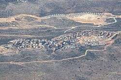
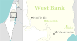
Leshem (Hebrew: לֶשֶם) is a religious Israeli settlement, which is also organized as a community village in western Samaria. It is located on Route 446, about 25 km (16 miles) east of Tel Aviv and about 37 km (23 miles) northwest of Jerusalem. Leshem is neighbored by the Israeli settlements of Alei Zahav, Peduel, Bruchin, Beit Aryeh-Ofarim, the archeological site of Deir Samaan, and the Palestinian villages Rafat, Kafr ad-Dik, and Deir Ballut.
Leshem settlement rises to a height of 360 meters (1181.1 feet) above sea level and is stretched across two hills, the eastern hill and the western hill which altogether cover about 497 dunam (122.811 acres).
Status under International Law
Leshem is located west of Alei Zahav, and is in the municipal area of it. According to the Israeli government, as well as the international community, the settlement of Leshem is an integral part of Alei Zahav settlement, and is recognized as an additional neighborhood of it. This recognition has given Leshem the name West Alei Zahav, and this is how Leshem is known in formal documents.
Leshem falls under the jurisdiction of the Shomron Regional Council, and while the international community considers it as part of Alei Zahav settlement, the Shomron Regional Council sees Leshem as a separate settlement.
While Israeli outposts are unauthorized by the Israeli law, Israeli settlements are considered illegal under international law, but the Israeli government disputes this.[1]
In October 2014, a High Court decision forbade the use of the main and only access road in and from Leshem, forcing the authorities to pave an alternative access road which connects Alei Zahav to Leshem. Later in 2016, a permanent access road was paved between the eastern and the western hills.
History
In 1999, Lubavitcher Chassidim expressed their interest in putting down roots in what is known today as the western hill of Leshem, and short after building permits had been acquired, construction of a new settlement started. The settlement was named Adanim.[2]
In the wake of the second intifada in 2000, the entrepreneurs decided to retire from the project, and the construction work was halted, leaving unfinished houses for another decade. During this period of time, the construction site was adopted by the IDF and police units to serve as a training site and was named "Chabad Elite" after the Lubavitcher Chassidim.
In 2010, "Harey Zahav" entrepreneurship received a concession on the land and in 2011 it renewed construction work. This time, major concentrated construction work efforts were made in the eastern hill side while building 70 homes within the time period of three years. Leshem settlement was finally founded in August 15, 2013.
After Leshem became a huge success, a second complex in 2013-2014 as well as a third complex in 2015-2016 doubled the size of the town to accommodate an increased demand for housing.
In 2014, construction work began in the western hill adjacent to Chabad Elite.
From 2013 and by the end of the first-half of 2017 another 130 families has joined the community while in 2017, Leshem population increased to around 900 residents, and is home to about 190 families.
Community
Leshem is made up of young religious Zionist families. The population of Leshem includes native-born Israelis as well as many Anglos and other immigrants (Olim) who have made aliyah from varied countries such as United States, Canada, United Kingdom, Australia, South Africa, as well as The Netherlands, Russia, Argentina, and France.
Etymology
Like Nofekh, Bareket, Shoham and Ahlama (the former name of Beit Arif) nearby, the name relates to one of the 12 stones of the Priestly Breastplate (Hoshen). Leshem is the name of the first gem stone in the third row (Exodus 28:19; 39:12)). The Hoshen consists of twelve gem stones when each of them represents a specific tribe from The Twelve Tribes of Israel, and whose name was inscribed on the stone. The Leshem gem stone color is believed to have an amber color, and is attributed to the tribe of Dan who, according to tradition, conquered a city by the very same name.
Educational and religious institutions
Leshem has several educational institutions such as kindergartens, preschools, nursery schools, and an elementary school which was named “Urim” after the honorable late Knesset Member Uri Orbach.
It also has a mikvah (a ritual bathhouse), a playground, a local branch of Bnei Akiva, and a community office. A commercial center is planned to be built in the next few years to accommodate a grocery store, infirmaries and more.
Leshem does not own an orthodox Synagogue yet. The first central synagogue in the eastern hill is currently under construction and the ground floor lobby of it will be ready by the end of 2018. In the meantime the residents of Leshem pray at a multi-purpose construction which serves as the temporary synagogue of the Leshem community. A second synagogue in the western hill is planned to be built in the next few years.
Archaeology
Adjacent to the area where Leshem was constructed is a Christian Byzantine farm named Dier Samaan. This phenomenal Archeological site reveals well-preserved agricultural instruments such as olive presses, winepresses, cisterns, ponds and in the center is a Basilican church. It is reasonable to assume that Dier Samaan can be dated back to the period of the Roman Empire between 63 BC to AD 324 when the Romans began to rule Israel.
References
- ↑ "The Geneva Convention". Middle East & Asia - West Bank Map - July 1992. BBC News. 10 December 2009. Retrieved 27 November 2010.
- ↑ "The University of Texas at Austin". Middle East & Asia - West Bank Map - July 1992. University of Texas Libraries. Retrieved 6 June 2017.