Hinanit
| Hinanit חִנָּנִית, חיננית | |
|---|---|
 Hinanit | |
| Coordinates: 32°28′49.07″N 35°10′19.56″E / 32.4802972°N 35.1721000°ECoordinates: 32°28′49.07″N 35°10′19.56″E / 32.4802972°N 35.1721000°E | |
| District | Judea and Samaria Area |
| Council | Shomron |
| Region | West Bank |
| Affiliation | HaMerkaz HaHakla'i |
| Founded | 1981 |
| Founded by | Mountain Jews |
| Population (2017)[1] | 1,295 |
| Name meaning | Daisy |
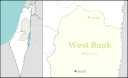
Hinanit (Hebrew: חִנָּנִית, lit. Daisy) is an Israeli settlement in the northern West Bank. It is organised as a community settlement and falls under the jurisdiction of Shomron Regional Council. Hinanit is located just across the Green Line border with Israel in the northern West Bank's Jenin Governorate, and to the north abuts the Palestinian village of 'Anin, from which it is separated by Israel's West Bank barrier. It lies approximately 9 miles (15 km) west of Jenin city. In 2017 it had a population of 1,295.
The international community considers Israeli settlements in the West Bank illegal under international law, but the Israeli government disputes this.[2]
History
The village was established in 1981 by Mountain Jews from the Caucasus. Originally a moshav and a member of the Moshavim Movement, it was later converted to a community settlement.
References
- ↑ "List of localities, in Alphabetical order" (PDF). Israel Central Bureau of Statistics. Retrieved August 26, 2018.
- ↑ "The Geneva Convention". BBC News. 10 December 2009. Retrieved 27 November 2010.