Tzofim
- This article is about the Israeli settlement. For the scout movement, see Israel Boy and Girl Scouts Federation.
| Tzufim צוּפִים / צוּפִין | |
|---|---|
| Hebrew transcription(s) | |
| • official | Tzufim |
 | |
 Tzufim | |
| Coordinates: 32°11′53″N 35°0′33″E / 32.19806°N 35.00917°ECoordinates: 32°11′53″N 35°0′33″E / 32.19806°N 35.00917°E | |
| District | Judea and Samaria Area |
| Council | Shomron |
| Region | West Bank |
| Founded | 1989 |
| Population (2017)[1] | 2,188 |
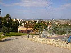
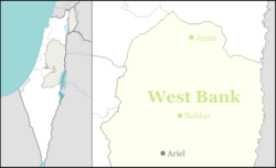
Tzufim (Hebrew: צוּפִים), or Tzufin (צוּפִין), is an Israeli settlement in the West Bank. Located in the Samarian mountains, north of Alfei Menashe and Qalqilyah and northeast of Kfar Saba, it is organised as a community settlement and falls under the jurisdiction of Shomron Regional Council. In 2017 it had a population of 2,188.
The international community considers Israeli settlements in the West Bank illegal under international law, but the Israeli government disputes this.[2]
History
Tzufim was established in 1989 with assistance from the Amana settlement organization. The population is made up of a mixed group of Orthodox and non-religious Israelis.
The village is located in an area described as the seam zone and its proximity to the Green Line (less than 2 kilometres east of it) and its similar proximity to the Palestinian town of Qalqilyah has made its inclusion on the Israeli side of the West Bank barrier controversial, especially as the looping nature of the barrier's path forms a quasi-enclave of some Arab villages to its south.
References
- ↑ "List of localities, in Alphabetical order" (PDF). Israel Central Bureau of Statistics. Retrieved August 26, 2018.
- ↑ "The Geneva Convention". BBC News. 10 December 2009. Retrieved 27 September 2011.
External links
- Village website (in Hebrew)