Lepe, Hampshire
| Lepe | |
|---|---|
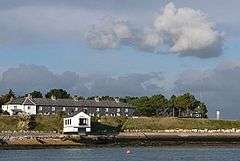 View towards the Coastguard cottages, Lepe | |
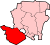
 Lepe Lepe shown within Hampshire | |
| OS grid reference | SZ450986 |
| Civil parish | |
| District | |
| Shire county | |
| Region | |
| Country | England |
| Sovereign state | United Kingdom |
| Post town | SOUTHAMPTON |
| Postcode district | SO45 |
| Dialling code | 023[1] |
| Police | Hampshire |
| Fire | Hampshire |
| Ambulance | South Central |
| EU Parliament | South East England |
| UK Parliament | |
Lepe is a small settlement on the Solent in the English county of Hampshire. At the 2011 Census the settlement population was included in the civil parish of Exbury and Lepe. It is located at the mouth of the Dark Water, and is the site of the Lepe Country Park, which runs from Stanswood Bay to the mouth of the Beaulieu River.
Overview
Lepe is a hamlet on shore of the Solent. It is part of the civil parish of Exbury and Lepe, which in turn is part of the New Forest district of Hampshire.[2] It is home to Lepe Country Park, with a mile of beach, pine-fringed cliffs, historic D-Day remains, and wild flower meadows.[3] There is a cafe-and-shop open all year round.[4]
From the cliff tops above the beach, commanding views of the Western Solent can be achieved resulting in a lookout position for Solent Rescue Independent Lifeboat station being placed there. Inchmery Quay lies to the west.
History
It is sometimes said that Lepe was a port in Roman times. The evidence for this is the apparent route of a Roman road, which ran down the eastern side of the New Forest, from the Totton area to Lepe.[5]
Lepe is first recorded in the 13th century.[6] The name may mean "leaping place," perhaps in relation to a jumpable stream, or other such crossing place.[6] It seems to have been part of Exbury manor, which in later times was frequently called the "manor of Exbury and Lepe."[7]
Tradition says that there was a village at Lepe that was destroyed by a great storm prior to the early 1700s. Two harbours, at Lepe and at Stone Point, are supposed to have been in existence also.[8] Information from old maps shows that the Dark Water used to flow out to the east of where it does now, near Stone Point.[9] An estate map of 1640 shows a tidal mill was situated at this location, and the tidal pond is still identifiable.[10] If there was a sudden change, then it may have occurred during the Great Storm of 1703 when the south coast of England was ravaged for five days.[9]
Lepe harbour survived, and in 1744 shipbuilder Moody Janverin was asked by the Admiralty to create a shipyard at Lepe.[11] Among the ships built at Lepe were HMS Greenwich (1747), HMS Fowey (1749), and HMS Europa (1765).[11] Lepe harbour had silted up by 1825.[12]
Around this time Lepe was involved in the oyster trade, large heaps of oysters being stacked here to purify.[7] There was also a wooden quay built at Lepe to serve the brickyards in the locality, until the coastal trade gradually diminished with the coming of the railways.[13] A coastguard station was built at Lepe to combat smuggling in the region.[11] Completed in 1828, the Coastguard Cottages and the Watch House remain largely unchanged today.[11]
In the 18th century, Lepe House was an inn, known as The Ship Inn,[11] but it was later enlarged and beautified to become a country house.[7] In 1943, it was requisitioned by the Royal Navy who used it as the base for J.1 Assault Group for the D-Day landings.[14]
In the past history they have had 3 floods one in 2004 one in 2005 and one in 2014
Lepe and D-Day, 1944

Prior to the invasion of Normandy in June 1944, Lepe was used as a secret manufacturing site. Six massive concrete caissons (type B2 Phoenix breakwaters) were built here and later towed across the English Channel where they formed part of the artificial Mulberry harbours after D-Day. Lepe was also one of the many places on the south coast of England used for the embarkation of troops and equipment for the invasion. Concrete mats like big chocolate blocks were used to reinforce the shingle beach for heavy traffic. Some of these mats can still be seen today along with pier remnants, bollards and various concrete and brick structures. Lepe was also the point where PLUTO (Pipeline Under The Ocean) left the mainland: it carried fuel across the Isle of Wight and under the English Channel to the Allied forces in Normandy and beyond.[15]
Notes
- ↑ http://stakeholders.ofcom.org.uk/telecoms/numbering/
- ↑ "Election Maps". Ordnance Survey. Retrieved 2010-02-02.
- ↑ Visitor information Archived 2011-10-28 at the Wayback Machine., Lepe Country Park
- ↑ Lepe Beach Café and Shop Archived 2011-10-22 at the Wayback Machine., Lepe Country Park
- ↑ Arthur Clarke, (2003), The Roman road on the eastern fringe of the New Forest, from Shorn Hill to Lepe. Proceedings of Hampshire Field Club and Archaeological Society, 58, 33-58.
- 1 2 Lepe, Old Hampshire Gazetteer Archived 2012-04-04 at the Wayback Machine.
- 1 2 3 Victoria County History of Hampshire: Exbury
- ↑ History of Lepe Archived 2011-11-07 at the Wayback Machine., Hantsweb
- 1 2 Lepe Beach and Stone Point, Hampshire, Geology of the Wessex Coast by Ian West
- ↑ Hampshire County Council, (2005), Archaeology and Historic Buildings Record
- 1 2 3 4 5 Lepe Estate - History
- ↑ Timeline, Coastal Communities, Hantsweb
- ↑ Hampshire Treasures Volume 5 (New Forest) Page 118 Archived 2012-06-09 at the Wayback Machine.
- ↑ Lepe House, Pastscape
- ↑ Knight, Smith & Barnett 1998, p. 21.
References
- "D-Day at Lepe" - Pamphlet. Hampshire County Council.
- Knight, Bob; Smith, Harry; Barnett, Barry (1998). Pluto – World War II's Best-Kept Secret. Bexley Council's Local Studies Centre et al.
External links
| Wikimedia Commons has media related to Lepe, Hampshire. |