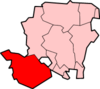
Colbury
| Colbury | |
|---|---|
 Colbury | |
 Colbury Colbury shown within Hampshire | |
| OS grid reference | SU348108 |
| Civil parish |
|
| District | |
| Shire county | |
| Region | |
| Country | England |
| Sovereign state | United Kingdom |
| Post town | SOUTHAMPTON |
| Postcode district | SO40 |
| Dialling code | 023[1] |
| Police | Hampshire |
| Fire | Hampshire |
| Ambulance | South Central |
| EU Parliament | South East England |
| UK Parliament | |
Colbury is a small village in the New Forest National Park, in Hampshire, England. The village lies along Deerleap Lane,[2] near the modern village of Ashurst.
History
The name Colbury is derived from Middle English for "Cola's manor",[3] and near Colbury is an estate called Langley which was held by "Cola the Hunter" in the Domesday Book of 1086.[4] The manor of Colbury was given to the Abbot of Beaulieu by Robert de Punchardon sometime in the 13th century.[2] A grant of free warren in the manor was made in 1359–60 to the Abbot and convent of Beaulieu.[2] Successive abbots remained in possession of the manor until the dissolution of the abbey in April 1538, when it passed to the Crown.[2] It was purchased in 1544 by John Mill and his son John. The elder John died in 1551 and the younger John was succeeded by his son Lewknor.[2] He died in November 1587, and his son Lewknor died in the following month, leaving John his brother and heir.[2] John was created a baronet in 1619, and the manor descended with the Mill Baronets until the death of the last baronet in 1835.[2]
The site of the Colbury Manor House is about a mile to the northeast of Colbury village, close to the village of Eling.[5] The house which is now there is modern, and no trace of ancient buildings survive.[5]
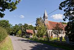
Colbury was for centuries a tithing in Eling parish. Its population in 1870 was 341 people.[6] The church in Colbury, called Christ Church, was built in 1870 by Benjamin Ferrey.[7]
The civil parish of Colbury was one of the parishes created out of the ancient parish of Eling in 1894.[2] Colbury parish was abolished in 1934 when 4722 acres were transferred to the parish of Denny Lodge and 750 acres were transferred to Totton and Eling.[8] The modern parish of Ashurst and Colbury was created in 1985, but administers a much small area than the old Colbury parish.
References
- ↑ "Telecoms numbering". ofcom.org.uk. 28 April 2010.
- 1 2 3 4 5 6 7 8 "Parishes: Eling". british-history.ac.uk.
- ↑ Colbury, Old Hampshire Gazetteer
- ↑ Anna Powell-Smith. "Langley - Domesday Book". domesdaymap.co.uk. Archived from the original on 2012-07-30.
- 1 2 "Hampshire Treasures". hants.gov.uk.
- ↑ John Marius Wilson, (1870-72) Imperial Gazetteer of England and Wales, page 24
- ↑ "Hampshire Treasures". hants.gov.uk.
- ↑ Relationships / unit history of COLBURY, www.visionofbritain.org.uk
External links
| Wikimedia Commons has media related to Colbury. |