Lee–Miles
| Lee–Miles | |
|---|---|
| Neighborhoods of Cleveland | |
 | |
| Coordinates: 41°26′25″N 81°33′53″W / 41.44014°N 81.564786°WCoordinates: 41°26′25″N 81°33′53″W / 41.44014°N 81.564786°W | |
| Country | United States |
| State | Ohio |
| County | Cuyahoga County |
| City | Cleveland |
| Population (2000) | |
| • Total | 16,063 |
| 2.5% increase from 1990 Census | |
| Demographics | |
| • White | 5% |
| • Black | 95% |
| • Hispanic | 0% |
| • Asian | 0% |
| • Other | >0% |
| Time zone | UTC-5 (EST) |
| • Summer (DST) | UTC-4 (EDT) |
| ZIP Codes | 44128, 44122 |
| Area code(s) | 216 |
| Median income | $35,337 |
| Source: 2000 U.S. Census, City Planning Commission of Cleveland [1] | |
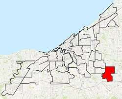
Lee–Miles is a neighborhood on the East Side of Cleveland, Ohio in Cleveland's Ward 1. The neighborhood is split into two sub-neighborhoods: Lee–Harvard and Miles–Seville.
Lee–Miles is bordered by the suburban cities of Shaker Heights to the north, Warrensville Heights to the east, Maple Heights to the south, Garfield Heights to the southwest and Cleveland's Union–Miles Park neighborhood to the northwest.
Parks and recreations
- Kerruish Park (located along the Mill Creek)
- Frederick Douglass Park
- Lee–Harvard Community Service Center
- John F. Kennedy Recreational Center
Education
- John F. Kennedy high school
- Whitney M. Young
- Charles W. Eliot School
- Citizens Academy Southwest
- Invictus High school
- Archbishop Lyke Campus
- Harvard Avenue Community School
- Ceogc Preschool
- Adlai Stevenson
- Charles W. Eliot School
Others
- Lee–Harvard Shopping Plaza
- Cleveland Industrial Park – this community's largest development site. At 114 acres, this industrial park is located near I-480 with interchanges at Lee Road and Broadway Avenue, and was created by city government in 1981. Since 1998, the city has marketed opportunities for new business and successfully secured several industries who made commitments to create 600 new jobs in the $40 million industrial development.
- Cleveland Fire Station #17
- MetroHealth Medical Center Lee–Harvard Hospital
- Cleveland Public Library – Lee–Harvard Branch
References
- ↑ "Buckeye-Shaker Neighborhood Fact Sheet" (PDF). Cleveland City Planning Commission. Archived from the original (PDF) on May 5, 2012. Retrieved January 5, 2011.
Places adjacent to Lee–Miles | ||||||||||
|---|---|---|---|---|---|---|---|---|---|---|
| ||||||||||

This article is issued from
Wikipedia.
The text is licensed under Creative Commons - Attribution - Sharealike.
Additional terms may apply for the media files.