Goodrich–Kirtland Park
| Goodrich–Kirtland Park | |
|---|---|
| Neighborhoods of Cleveland | |
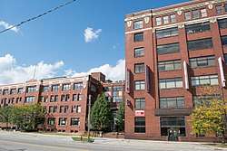 Tyler Village complex | |
 | |
| Coordinates: 41°30′45″N 81°39′47″W / 41.51250°N 81.66306°W | |
| Country | United States |
| State | Ohio |
| County | Cuyahoga County |
| City | Cleveland |
| Population (2010) | |
| • Total | 4,103 |
| Demographics | |
| • White | 35.1% |
| • Black | 21.8% |
| • Hispanic | 10.8% |
| • Asian | 30.8% |
| • Other | 1.6% |
| Time zone | UTC-5 (EST) |
| • Summer (DST) | UTC-4 (EDT) |
| ZIP Codes | 44103, 44114 |
| Area code(s) | 216 |
| Median income | $25,509[1] |
| Source: 2010 U.S. Census, NEO CANDO [2] | |
Goodrich–Kirtland Park is a neighborhood on the east side of Cleveland, Ohio. Roughly bounded between Euclid Avenue to the south, E. 55th Street to the east, I-90 to the west, and Lake Erie and Burke Lakefront Airport airport to the north.[3]
To most locals, the area is most known as Asiatown.
The neighborhood is home to the Ohio Technical College, located at E. 51st Street and St. Clair Avenue.
Points of interest
- Body Block (4925-4955 Payne Avenue and 1692-1696 E. 55th Street)
- Children's Museum of Cleveland (3813 Euclid Avenue)
- Ohio Technical College (1269, 1374 East 51st Street)
References

Places adjacent to Goodrich–Kirtland Park | ||||||||||
|---|---|---|---|---|---|---|---|---|---|---|
| ||||||||||
This article is issued from
Wikipedia.
The text is licensed under Creative Commons - Attribution - Sharealike.
Additional terms may apply for the media files.