Laughing Whitefish Falls State Park
| Laughing Whitefish Falls | |||||||||||||||||||
|---|---|---|---|---|---|---|---|---|---|---|---|---|---|---|---|---|---|---|---|
 | |||||||||||||||||||
| Location | Alger County, Michigan | ||||||||||||||||||
| Coordinates | 46°23′02″N 87°04′07″W / 46.38389°N 87.06861°WCoordinates: 46°23′02″N 87°04′07″W / 46.38389°N 87.06861°W[1] | ||||||||||||||||||
| Type | Fan | ||||||||||||||||||
| Total height | 100 feet (30 m) | ||||||||||||||||||
| Number of drops | 1 | ||||||||||||||||||
| Watercourse | Laughing Whitefish River | ||||||||||||||||||
| |||||||||||||||||||

Laughing Whitefish Falls State Park is a waterfall and state park located in Onota Township and Rock River Township, in far western Alger County, Michigan. The waterfall is in the southern part of the site, in Rock River Township, 8 miles (13 km) south of Lake Superior near M-94.[2]
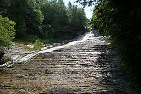
Laughing Whitefish Falls is formed by an abrupt limestone escarpment of the Laughing Whitefish River, which flows northward into Lake Superior. The escarpment is shaped so as to draw out the cascade into an unusual fan-shaped wall of water. The falls is located within the Escanaba River State Forest. Foot trails connect the falls to the North Country Trail, which runs through the north end of the park.[2]
From M-94, a 2.8-mile (4.5 km) drive northward on Dorsey Road and a one-mile (1.5 km) hike from the roadhead are necessary to reach the falls.[3]
References
- 1 2 "Laughing Whitefish Falls". Geographic Names Information System. United States Geological Survey.
- 1 2 "Laughing Whitefish Falls State Park". Michigan Department of Natural Resources. Retrieved July 7, 2018.
- ↑ Michigan Atlas and Gazetteer (10th ed.). Yarmouth, Maine: DeLorme. 2002.
External links
- Laughing Whitefish Falls State Park Michigan Department of Natural Resources