Las Tablas, Los Santos
| Las Tablas | |
|---|---|
| City | |
 Las Tablas | |
| Coordinates: 7°46′N 80°17′W / 7.767°N 80.283°WCoordinates: 7°46′N 80°17′W / 7.767°N 80.283°W | |
| Country |
|
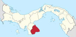
| Province | Los Santos |
| District | Las Tablas |
| Founded | 1671 |
| Area[1] | |
| • Land | 7.5 km2 (2.9 sq mi) |
| Elevation | 42 m (138 ft) |
| Population (2010)[1] | |
| • Total | 8,945 |
| • Density | 1,197.6/km2 (3,102/sq mi) |
| Population density calculated based on land area. | |
| Time zone | UTC−5 (EST) |
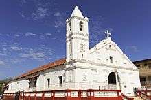
Las Tablas (Spanish pronunciation: [las ˈta.βlas]) is the capital of the Panamanian province of Los Santos, with a population of 8,945 as of 2010.[1] It is located a few kilometres inland from the Gulf of Panama on the Azuero Peninsula. Las Tablas is a recognised national centre of Panamanian folk: Art, music, gastronomy, architecture, culture and literature. The only Panamanian president to serve three terms, Belisario Porras, was from Las Tablas.
It is known for a lively yearly Carnival, in which the city splits into two competing factions, "Calle Arriba" (Uptown, literally "Street Above") and "Calle Abajo" (Downtown / Street Below), both centred on two streets of the same name. Each faction will have a carnival queen, a parade, fireworks, music, a decorated plaza, food stands, presentations, concerts, surveys, games, contests, etc., all attempting to overpower the other faction's efforts.
Etymology
According to folklore, the town takes its name, which translates as "The Boards", from planks of wood salvaged from a Spanish ship used to construct the first houses in the town. The ship had run aground on the coast near the city's future location after fleeing Panama City before the arrival of Henry Morgan.
References
- 1 2 3 "Cuadro 11 (Superficie, población y densidad de población en la República...)" [Table 11 (Area, population, and population density in the Republic...)] Archived 2016-03-04 at the Wayback Machine. (.xls). In "Resultados Finales Básicos" [Basic Final Results] (in Spanish). National Institute of Statistics and Census of Panama. Archived from the original on July 10, 2015. Retrieved May 26, 2015.
External links
- Cuna del Folklore Nacional (Spanish) Retrieved March 27, 2005
- Las Tablas Carnival info and pictures