Langdon, Kansas
| Langdon, Kansas | |
|---|---|
| City | |
 Location within Reno County and Kansas | |
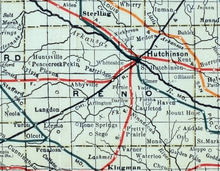
 KDOT map of Reno County (legend) | |
| Coordinates: 37°51′12″N 98°19′28″W / 37.85333°N 98.32444°WCoordinates: 37°51′12″N 98°19′28″W / 37.85333°N 98.32444°W | |
| Country | United States |
| State | Kansas |
| County | Reno |
| Area[1] | |
| • Total | 0.12 sq mi (0.31 km2) |
| • Land | 0.12 sq mi (0.31 km2) |
| • Water | 0 sq mi (0 km2) |
| Elevation | 1,693 ft (516 m) |
| Population (2010)[2] | |
| • Total | 42 |
| • Estimate (2016)[3] | 41 |
| • Density | 350/sq mi (140/km2) |
| Time zone | UTC-6 (CST) |
| • Summer (DST) | UTC-5 (CDT) |
| ZIP code | 67583 |
| Area code | 620 |
| FIPS code | 20-38500 [4] |
| GNIS ID | 0473778 [5] |
Langdon is a city in Reno County, Kansas, United States. As of the 2010 census, the city population was 42.[6]
History
The first post office in Langdon was established in 1873.[7] Langdon was named for a local businessman.[8]
In 1887, the Chicago, Kansas and Nebraska Railway built a main line from Herington through Langdon to Pratt.[9] In 1888, this line was extended to Liberal. Later, it was extended to Tucumcari, New Mexico and El Paso, Texas. It foreclosed in 1891 and taken over by Chicago, Rock Island and Pacific Railway, which shut down in 1980 and reorganized as Oklahoma, Kansas and Texas Railroad, merged in 1988 with Missouri Pacific Railroad, merged in 1997 with Union Pacific Railroad. Most locals still refer to this railroad as the "Rock Island".
Geography
Langdon is located at 37°51′12″N 98°19′28″W / 37.85333°N 98.32444°W (37.853349, -98.324495).[10] According to the United States Census Bureau, the city has a total area of 0.12 square miles (0.31 km2), all of it land.[1]
Demographics
| Historical population | |||
|---|---|---|---|
| Census | Pop. | %± | |
| 1920 | 204 | — | |
| 1930 | 181 | −11.3% | |
| 1940 | 208 | 14.9% | |
| 1950 | 128 | −38.5% | |
| 1960 | 97 | −24.2% | |
| 1970 | 93 | −4.1% | |
| 1980 | 84 | −9.7% | |
| 1990 | 62 | −26.2% | |
| 2000 | 72 | 16.1% | |
| 2010 | 42 | −41.7% | |
| Est. 2016 | 41 | [3] | −2.4% |
| U.S. Decennial Census | |||
2010 census
As of the census[2] of 2010, there were 42 people, 20 households, and 11 families residing in the city. The population density was 350.0 inhabitants per square mile (135.1/km2). There were 35 housing units at an average density of 291.7 per square mile (112.6/km2). The racial makeup of the city was 95.2% White and 4.8% Native American.
There were 20 households of which 20.0% had children under the age of 18 living with them, 45.0% were married couples living together, 5.0% had a female householder with no husband present, 5.0% had a male householder with no wife present, and 45.0% were non-families. 40.0% of all households were made up of individuals and 25% had someone living alone who was 65 years of age or older. The average household size was 2.10 and the average family size was 2.91.
The median age in the city was 50.3 years. 14.3% of residents were under the age of 18; 9.6% were between the ages of 18 and 24; 12% were from 25 to 44; 42.8% were from 45 to 64; and 21.4% were 65 years of age or older. The gender makeup of the city was 52.4% male and 47.6% female.
2000 census
As of the census[4] of 2000, there were 72 people, 30 households, and 18 families residing in the city. The population density was 550.9 people per square mile (213.8/km²). There were 39 housing units at an average density of 298.4 per square mile (115.8/km²). The racial makeup of the city was 93.06% White, 1.39% Native American, 1.39% from other races, and 4.17% from two or more races. Hispanic or Latino of any race were 1.39% of the population.
There were 30 households out of which 23.3% had children under the age of 18 living with them, 46.7% were married couples living together, 10.0% had a female householder with no husband present, and 40.0% were non-families. 40.0% of all households were made up of individuals and 10.0% had someone living alone who was 65 years of age or older. The average household size was 2.40 and the average family size was 3.22.
In the city, the population was spread out with 27.8% under the age of 18, 9.7% from 18 to 24, 15.3% from 25 to 44, 33.3% from 45 to 64, and 13.9% who were 65 years of age or older. The median age was 42 years. For every 100 females, there were 94.6 males. For every 100 females age 18 and over, there were 85.7 males.
The median income for a household in the city was $36,250, and the median income for a family was $45,833. Males had a median income of $33,750 versus $14,375 for females. The per capita income for the city was $17,136. There were 22.2% of families and 24.2% of the population living below the poverty line, including 44.4% of under eighteens and none of those over 64.
Further reading
References
- 1 2 "US Gazetteer files 2010". United States Census Bureau. Archived from the original on 2012-07-14. Retrieved 2012-07-06.
- 1 2 "American FactFinder". United States Census Bureau. Retrieved 2012-07-06.
- 1 2 "Population and Housing Unit Estimates". Retrieved June 9, 2017.
- 1 2 "American FactFinder". United States Census Bureau. Retrieved 2008-01-31.
- ↑ "US Board on Geographic Names". United States Geological Survey. 2007-10-25. Retrieved 2008-01-31.
- ↑ "2010 City Population and Housing Occupancy Status". U.S. Census Bureau. Archived from the original on July 26, 2011. Retrieved March 27, 2011.
- ↑ "Kansas Post Offices, 1828-1961". Kansas Historical Society. Retrieved 22 June 2014.
- ↑ "Profile for Langdon, Kansas". ePodunk. Retrieved 22 June 2014.
- ↑ Rock Island Rail History
- ↑ "US Gazetteer files: 2010, 2000, and 1990". United States Census Bureau. 2011-02-12. Retrieved 2011-04-23.
External links
| Wikimedia Commons has media related to Langdon, Kansas. |
- City
- Schools
- USD 310, local school district
- Maps
- Langdon City Map, KDOT
Municipalities and communities of Reno County, Kansas, United States | ||
|---|---|---|
| Cities | 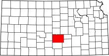 | |
| CDP | ||
| Unincorporated communities | ||
| Ghost towns | ||
| Townships |
| |