Landi Kotal
| Landi Kotal لنډي کوتل Lwargai | |
|---|---|
| Town | |
 Landi Kotal  Landi Kotal | |
| Coordinates: 34°6′19″N 71°9′19″E / 34.10528°N 71.15528°ECoordinates: 34°6′19″N 71°9′19″E / 34.10528°N 71.15528°E | |
| Country |
|
| Province |
|
| District | Khyber Agency |
| Tehsil | Landi Kotal |
| Elevation | 1,072 m (3,517 ft) |
| Population (2017)[1] | |
| • Total | 33,697 |
| Time zone | UTC+5 (PST) |
| Calling code | 0924 |
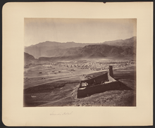
Lanḍī Kōtal (Pashto: لنډي کوتل; Urdu: لنڈی کوتل) or Lwāṛgai (Pashto: لواړګی) is a town in the Khyber Pakhtunkhwa province of Pakistan, and the administrative capital of Khyber Agency. It is one of the largest towns in the Federally Administered Tribal Areas, and is located 1,072 metres (3,517 ft) above sea level, on the route across the mountains to the city of Peshawar, Khyber Pakhtunkhwa, Pakistan.[2][3][4] Landi Kotal is at the western edge of the Khyber Pass that marks the entrance to the Nangarhar Province of Afghanistan, which is located just 5 kilometres (3 mi) to the west.
Landi Kotal is a tourist destination. It was the terminus railway station of Khyber Pass Railway. A tourist train, the Khyber train safari was run on this railway. However, the train was closed down in 2006 due to washing away of the railway track and bridges by flood.
Landi Kotal is the main shopping centre for both the Shinwari and Afridi tribes of Khyber Agency.
History
Landi Kotal was the westernmost part of the Khyber held by the British during their rule of the subcontinent.[5] In 1897 the Afridis attacked Landi Kotal and other posts in the Khyber Pass. Although the Khyber Rifles put up a stiff defence, Landi Kotal was overrun,[6] as the Rifles lacked water.[7] The British counter-attacked with a force of 34,500 men under Sir William Lockhart, defeating the Afridis, although the Afridis took the town again during the second Anglo-Afghan War.[8]
The Landi Kotal fort during the period of British rule was of the ordinary type, consisting of a keep and an outer fort with accommodation for 5 British officers and 500 native officers and men. From 1899, like the other posts in the Khyber, it had been garrisoned by the Khyber Rifles, an irregular corps of militia recruited from the tribes of the Khyber Agency.[6]
In 1925 the heavily engineered Khyber Pass Railway was opened linking Jamrud to the Landi Kotal.[4]
See also
References
- ↑ "POPULATION AND HOUSEHOLD DETAIL FROM BLOCK TO DISTRICT LEVEL: FATA (KHYBER AGENCY)" (PDF). www.pbscensus.gov.pk. 2018-01-03. Retrieved 2018-04-01.
- ↑ Photo caption for Landi Kotal WDL11475.png, Library of Congress
- ↑ Location of Landi Kotal – Falling Rain Genomics
- 1 2 Landi Kotal
- ↑ Landi Kotal – Imperial Gazetteer of India, v. 16, p. 134.
- 1 2 Landi Kotal – Imperial Gazetteer of India, v. 16, p. 135.
- ↑ Khyber – Imperial Gazetteer of India, v. 15, p. 303.
- ↑ Tīrāh – Imperial Gazetteer of India, v. 23, p. 390.
External links
| Wikivoyage has a travel guide for Landi Kotal. |