Lake Natoma
| Lake Natoma | |
|---|---|
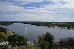 A photograph of Lake Natoma, looking towards Folsom, California | |
| Location | Sacramento County, California |
| Coordinates | 38°39′15″N 121°11′33″W / 38.654031°N 121.192497°WCoordinates: 38°39′15″N 121°11′33″W / 38.654031°N 121.192497°W |
| Type | Reservoir |
| Primary inflows | American River |
| Primary outflows | American River |
| Catchment area | 1,898 sq mi (4,920 km2) |
| Basin countries | United States |
| Average depth | 46 ft (14 m) |
| Water volume | 8,760 acre feet (10,810 dam3) |
| Shore length1 | ~10 mi (16 km) |
| Surface elevation | 128 ft (39 m) |
| Settlements | Folsom, California |
| 1 Shore length is not a well-defined measure. | |
Lake Natoma is an intermediate lake along the lower American River,[1] located between Folsom Dam and Nimbus Dam in Sacramento County, in the U.S. state of California. The lake is located within the Folsom Lake State Recreation Area. From the Folsom Lake Dam, Lake Natoma is located east of Sacramento, and is about 500 acres of surface area away from the dam.[2]
It is a recreational lake for rowing, kayaking and swimming. Powerboats are permitted with a 5 mph "no wake" restriction. Lake Natoma is also home to the Sacramento State Aquatic Center, and regularly hosts West Coast College Rowing Championships, the Pac-12 Conference rowing championships, and, every four years, the Intercollegiate Rowing Association Championships. The Lake Natoma Four Bridges Half Marathon is held each October at the lake.
Lake Natoma includes the historic Negro Bar area in Folsom, the site of a gold rush era African-American mining camp.
The Folsom Powerhouse State Historic Park overlooks Lake Natoma in the city of Folsom. It is a California State Historical site, preserving an early hydroelectric power station.
A paved cycling and jogging trail encircles the lake along with unpaved equestrian trails. The Folsom South Canal Trail also begins at the lake. Several parking lots and boat launching ramps are located around the lake.
History
In the 1950s, after Folsom Dam was built, Folsom Lake and Lake Natoma were built to manage water flow for the lower American River released from Folsom Dam.[3] Lake Natoma is a reservoir built by the Central Valley Project. It not only maintains water flow but provides water, generates energy supply, and prevents flooding.[4] After Lake Natoma and Folsom Lake were built, the Bureau of Recamation had control of operation.[5] The area was once a mining site for gold.[4] Around 1956, the Bureau of Reclamation and California Department of Parks and Recreation, also known as State Parks, formed an agreement that State Parks will be responsible for recreational activities on Lake Natoma, including Folsom Lake.[5]
In 1979, the general plan for the State Recreational Area at Folsom Lake, including Lake Natoma, was amended three times before it was approved.[4] As part of the 1979 General Plan amendment, the Folsom Powerhouse State Historic Park became a separate unit, not a part of the Folsom Unit.[4]
In 2002, multiple meetings were held for public input and for interested stakeholder to plan and prepare for recreational purposes adequate enough for the growing populations. There was a 62% increase in population since the General Plan was accepted in 1979.[4]
Folsom Powerhouse State Historic Park
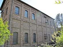
To the west bank of Lake Natoma lies the Folsom Powerhouse State Historic Park, located in the City of Folsom at the intersection of Riley and Scott Streets.[6] The Folsom Powerhouse brought in the first powerhouses that generated in 1985.[4] The powerhouse opened until 1952 because the Folsom Dam ruined the old dam to the powerhouse during construction.[6] This historic site used to bring 11,000 volts over 22 miles to Sacramento for energy.[4] The site is under the National Register of Historic Places.[6] There is a visitor center where the public can learn more about the history of the park.
Physical features
Surrounding this narrow lake are foothills, plateaus, cliffs and river canyons.[4] A riparian runs 14 miles along the lake.[4] The Lake Natoma Bluffs stand 300 feet and line the lake from the Negro Bar to the Mississippi Bar.[6]
Recreational activities
People come to this area for many activities, especially in the summer. The area is accessible via nearby freeways.[4] Since these reservoirs are located in the metropolitan area, the State Recreational Area (SRA) tries to create a habitat suitable for the wildlife that are already living there, to have both "recreation and nature."[4] By 2000, there were over 1.5 million visitors to Folsom Lake State Recreation Area, including Lake Natoma and Folsom Lake.[6]
Water and land uses
Lake Natoma was first ready for the public in 1958.[6] The common water activities are kayaking, rowing, canoeing, swimming, water skiing, sailing, and fishing. Land activities include hiking, biking, picnicking, jogging, biking, and horseback riding.[4] Educational activities are also available, including about historical sites nearby Lake Natoma and Folsom Lake, the common fish that spawn in the American River, the history of the California Gold Rush, and Native American life before the Europeans' arrival.[4]
Major facilities
Boat launch
The lake has three boat launches for powerboats, jetskis, and sailboats.[6] These launches are well designed with hard surfaces, enough room to turn around, and parking areas.[6] Fishermen like to use Folsom Point to launch, as many fishing tournament events occur nearby.[6] California State University Sacramento (CSUS) holds waterskiing classes here.[6]
Campgrounds
There are three campgrounds open to the public: Peninsula Campground, Beals Point Campground, and Negro Bar Group Campground.[6]
Willow Creek
Located at the Willow Creek inlet to Lake Natoma, this area is used for both land and water activities.[6] The area is used for picnicking, birdwatching, fishing, and canoeing. Lake Natoma Trail is nearby.[6]
Negro Bar
The Negro Bar is another day facility that lines one mile of Lake Natoma's shoreline, from the Lake Natoma Bluffs to the south and Old Rainbow Bridge.[6] At the lower portion, Lake Natoma is great for picnics, as there is shade.[6] Tables and a restroom are available. The area is also a nice place to fish, paddle, swim, and sunbathe.
Aquatic Center for CSUS
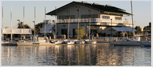
Where the Nimbus Dam ends, there is an Aquatic Center right on Lake Natoma that belongs to the California State University Sacramento (CSUS).[6] This is where CSUS holds some of their aquatic classes, such as skiing and wind surfing.[6]
Bike path
A bike path follows along the East Trail and West Trail of Nimbus Dam that lines Lake Natoma.[6]
Dirt trails
Six miles of dirt trail lead to Nimbus Flat and Willow Creek.[6] There are also dirt trails on both sides of Lake Natoma; one is six miles and other is nine miles.
Nimbus Fish Hatchery
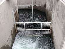
Under Nimbus Dam and Lake Natoma lies the Nimbus Fish Hatchery, operated by the California Department of Fish and Games, that was built in 1955 by the U.S Bureau of Reclamation.[6] The California Department of Fish and Games operates a visitor center here.[6] The hatchery replicates spawning environments by creating a fish ladder that guides salmon and steelheads to spawn.[6] For recreational fishing in the northern and Central California bodies of water, the hatchery produces 4 million Chinook salmon and over 400,000 Steelhead trout per year.[6]
Animals
Native animals known to lie here are the mule deer, coyote, bobcat, mountain lion, quail, bald and golden eagle, heron, egret, western pond turtle, and California horned lizard.[4] A few common fish in Lake Natoma are catfish and carp. Aquatic animals in Lake Natoma are usually tolerant of warm water and low oxygen level water.[7] Other fish found here are bass, bluegill, and green sunfish.[7] Right under Nimbus Dam are steelheads, Chinook salmon, American shad, and Pacific lampreys.[7] Bald eagles and golden eagles can be found around Folsom Lake and Lake Natoma for nesting; about six bald eagles and two golden eagles are observed annually.[7] Both are protected under the Federal Bald Eagle Protection Act of 1940.[7]
Environmental issues
Mercury
Fish at Lake Natoma were found to have high levels of mercury in their tissue. A sample of 22 fish showed that mercury levels had approached or exceed guidelines set by the U.S. Environmental Protection Agency, which is set at 3 microgram Hg/g wet weight.[8] Since there were too few samples, it is not known for sure if mercury is randomly distributed throughout Lake Natoma.[8] Concentration of mercury increases as sizes of fish increase, usually because of bioaccumulation. Factors include length, weight, and age.[8] For example, predators that at on the top of the food chain, such as large bass mouth, spotted bass, and white catfish, usually have higher concentrations.[8]
The California Office of Environmental Health Hazard Assessment (OEHHA) has developed a safe eating advisory for Lake Natoma, based on levels of mercury found in fish caught here.[9]
See also
External links
References
- Saiki, M.K. (2004). Summary of total mercury concentrations in fillets of selected sport fishes collected during 2000-2003 from Lake Natoma, Sacramento County, California [Data Series 103]. Reston, VA: U.S. Department of the Interior, U.S. Geological Survey.
- ↑ "History". www.sacstateaquaticcenter.com. Retrieved 2018-04-29.
- ↑ Klasing, Susan (2004). "Fish consumption guidelines for Lake Natoma (including nearby creeks and ponds) and the lower American River (Sacramento County)" (PDF). California Office of Environmental Health Hazard Assessment: 6.
- ↑ "History". www.sacstateaquaticcenter.com. Retrieved 2018-04-29.
- 1 2 3 4 5 6 7 8 9 10 11 12 13 14 Folsom Lake State Recreation Area and Folsom Powerhouse State Historic Park: General Plan/Resource Management Plan. 2007. pp. I-11.
- 1 2 "Folsom Lake Recreation Area General Plan/Resource Management Plan Update" (PDF). California State Parks. 2003. Retrieved April 29, 2018.
- 1 2 3 4 5 6 7 8 9 10 11 12 13 14 15 16 17 18 19 20 21 22 23
- 1 2 3 4 5 Associates, LSA (2003). "NATURAL RESOURCES ANIMAL LIFE" (PDF). Folsom Lake State Recreation Area: AL1–AL49.
- 1 2 3 4 Saiki, Michael K.; MARTIN, BARBARA A. (2005). [file:///C:/Users/litto/AppData/Local/Packages/Microsoft.MicrosoftEdge_8wekyb3d8bbwe/TempState/Downloads/CDFG_2005.pdf "Total Mercury Concentration in fillets of Bluegill, Redear Sunfish, Largemouth Bass, and other Fishes from Lake Natoma, Sacramento County, California"] Check
|url=value (help) (PDF). California Fish and Game. 91 (3): 193–206. - ↑ Admin, OEHHA (2014-12-30). "Lake Natoma". OEHHA. Retrieved 2018-06-13.