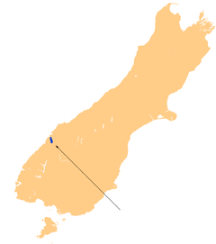
Lake McKerrow
| Lake McKerrow | |
|---|---|
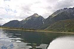 Jetboat ride along Lake McKerrow | |
 Lake McKerrow | |
| Location | Fiordland, Southland District, Southland Region, South Island |
| Coordinates | 44°26′S 168°03′E / 44.433°S 168.050°ECoordinates: 44°26′S 168°03′E / 44.433°S 168.050°E |
| Primary inflows | Hollyford River |
| Primary outflows | Hollyford River |
| Basin countries | New Zealand |
| Surface area | 28 km2 (11 sq mi) |
Lake McKerrow, also known by the Māori name of Whakatipu Waitai, lies at the northern end of Fiordland, in the southwest of New Zealand's South Island. The lake runs from southeast to northwest, is 15 kilometres in length, and covers 28 km².
Lake McKerrow drains, and is drained by, the Hollyford River. It is one of two lakes (along with Lake Alabaster) found in the lower reaches of the Hollyford River system, and the Hollyford Track, one of New Zealand's most well-known and popular tramping tracks, follows its eastern shore for its full length.
The lake is technically a fiord which has been cut off from the Tasman Sea by sediment. The sea is now three kilometres from the lake's northern end.
The Alpine Fault goes through the lake. Researchers from GNS Science and University of Nevada, Reno have studied sediments from the 24 last Alpine Fault earthquakes near the lake and have found the most regular rupture behaviour yet observed.[1]
References
| Wikimedia Commons has media related to Lake McKerrow. |
- ↑ Gorman, Paul; Michael Daly (28 June 2012). "Big Alpine Fault quake may be 'in near future'". The Press. Retrieved 2 July 2012.