Lake Makgadikgadi
| Lake Makgadikgadi | |
|---|---|
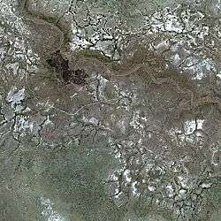 The present day bed of the former Lake Makgadikgadi seen by the SPOT Satellite. | |
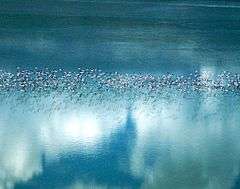 The Makgadikgadi Salt Pans in Botswana are one of the most important breeding sites in Southern Africa for lesser and greater flamingos | |
| Location | Kalahari Desert in Botswana |
| Basin countries | Botswana |
| Average depth | 30 metres (98 ft) |
Lake Makgadikgadi was a paleolake that existed in what is now the Kalahari Desert in Botswana from 2,000,000 years BP to 10,000 years BP. It may have once covered an area of from 80,000 km² to 275,000 km² and was 30 m deep [1]. The Okavango, Upper Zambezi, and Cuando rivers once all emptied into the lake. Its remains are seen in the Makgadikgadi salt pans , one of the largest salt pans in the world.
Meaning of the name
The name Makgadikgadi is derived from the same root as the name for the desert Kalahari, meaning a dry thirsty place in the languages of the San people.[2]
Origin and history
Approximately 3 million years ago, strong easterly winds formed long dunes which ran from east to west across the middle of the Kalahari Desert. During wetter times, these dunes channeled the great rivers of the area, the Okavango, Chobe, and Upper Zambezi, south eastwards to join with the Limpopo River and drain into the Indian Ocean.
Northern Botswana has a series of deep, underlying fault lines running beneath its sands. These faults are thought to be the southernmost extensions of the same system of parallel fault lines that are pulling away from each other and have formed East Africa's Great Rift Valley. [3] Parts of the courses of both the Linyanti River and Chobe River, mark the lie of these faults today .[3]
Approximately 2 million years ago, the fault known as the Ovamboland-Kalahari-Zimbabwe axis (which runs from NE to SW from Harare through Bulawayo and ends in the east side of the Kalahari) moved in an epeirogenic flexure, and cut off the drainage route into the Limpopo. The blockage created an enormous basin and forced these rivers to flow into and fill it up. Lake Makgadikgadi was thus created.
The great Magwikwe Sand Ridge between Savuti and North Gate, probably defined one of its northwestern shorelines. Another is thought to have been the less obvious Gidikwe Sand Ridge, which lies just to the west of the western border of the present Makgadikgadi National Park.
Wave washed features can be found on several of the Kalahari's higher places in this region. The eastern side of the Gchoha Hills, north of Savuti, are a particularly clear example of this. Round water eroded pebbles can also be found.
As the millennia passed, the lake filled to capacity and it began to overflow about 20,000 years ago taking the lowest point in the watershed in the north east as its new outlet. This caused the middle and lower Zambezi Rivers to connect, forming the Victoria Falls. With the water now able to flow out of the basin, Lake Makgadikgadi drained partially and its average level decreased.
A drier climatic period followed which increased evaporation and decreased the flow of the rivers that fed the lake. By about 10,000 years ago the drying of Lake Makgadikgadi was in an advanced stage. Sediment and debris from the Okavango River and windblown sand were gradually filling the lake.[3]
The Gumare fault formed and lowered the land. As a result, the water of the Okavango River spread out over a much larger area of land than it previously did, forming the now characteristic fan-shaped inland delta of the Okavango, which further reduced the water that flowed into Lake Makgadikgadi and hastened its demise.
Ecology
Lake Makgadikgadi is theorized to have been the birthplace of the vast number of cichlids[4] that once swam the Congo River, Zambezi River, Okavango River and Limpopo River - as many as 100 to 400 new species, of which approximately 25 survive today. The lake's sheer size may have provided the ancestors of these fish with an extremely wide range of new ecological niches to exploit and thus could have served as the stimulus for the evolution of the new species, which they may have done in record time before the lake drained completely. The theory further says that the new species, after having evolved within the confines of the lake, could have escaped with the lakewater as it drained, and populated the rivers of the region to evolve into the cichlids that exist today.
In current times this land is desiccated most of the year and is a seasonal wetland in the rainy summer months.[5]
Legacy
Today the only remains of Lake Makgadikgadi are the Okavango Delta, the Nxai Pan, Lake Ngami, Lake Xau, the Mababe Depression, and the two main Makgadikgadi pans: the Sua Pan and the Nwetwe Pan.
The Makgadikgadi Salt Pans are among the largest in the world and are formed from the last remnants of this great lake. The Okavango Delta is a very large, swampy inland delta formed where the Okavango River reaches the former bed of the lake. It is now an endorheic basin in which all the water reaching the basin is ultimately evaporated and transpired,
The other south draining rivers that once fed the lake have now all been captured by the Zambezi River.
Sources
References
- ↑ "Makgadikgadi Salt Pans". earthobservatory.nasa.gov. 2018-07-06. Retrieved 2018-08-16.
- ↑ "Botswana Travel Article | Origins of the Names of Places in Botswana". www.botswana.co.za. Retrieved 2018-08-19.
- 1 2 3 "Geological history - Botswana Travel Guide". www.botswana-travel-guide.com. Retrieved 2018-08-15.
- ↑ J. Owen, 2005
- ↑ C. M. Hogan, 2008
External links
| Wikimedia Commons has media related to Lake Makgadikgadi. |