Lake Lawtonka
| Lake Lawtonka | |
|---|---|
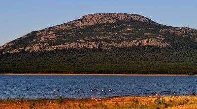 East Shore of Lake Lawtonka at Sunset, with Canada Geese. Mount Scott in Background. Photo by Schyler, August 1, 2011. | |
| Location | Comanche County, Oklahoma |
| Coordinates | 34°45′21″N 98°30′15″W / 34.7559°N 98.5041°WCoordinates: 34°45′21″N 98°30′15″W / 34.7559°N 98.5041°W |
| Type | reservoir |
| Primary inflows | Medicine Creek |
| Primary outflows | Medicine Creek |
| Catchment area | 92 sq mi (240 km2) |
| Basin countries |
|
| Managing agency | City of Lawton |
| Built | 1905 |
| Surface area | 2,325 acres (941 ha) |
| Average depth | 23.6 ft (7.2 m) |
| Max. depth | 58.4 ft (17.8 m) |
| Water volume | 63,000 acre⋅ft (0.078 km3) |
| Shore length1 | 19.2 mi (30.9 km) |
| Surface elevation | 1,345.55 ft (410.12 m) |
| Settlements | Lawton, Medicine Park, Meers |
| References | [1][2][3] |
| 1 Shore length is not a well-defined measure. | |
Lake Lawtonka is a lake in Comanche County in the state of Oklahoma in the United States.[4][5]
The lake is 2 square miles (5 square kilometers) in area. It is formed by a dam 60 feet (18 meters) high and 375 feet (114 meters) long across Medicine Bluff Creek.[6][7] The lake provides the water supply for Fort Sill and Lawton to the south.[5]
Recreation
Fishing and camping facilities are maintained by the City of Lawton, Oklahoma.[8]
See also
References
- ↑ Oklahoma Water Resource Board. "Hydrographical Survey of Lake Lawtonka (2006)" (pdf). Retrieved 2010-05-15.
- ↑ "Lake Lawtonka" (pdf). Oklahoma Water Resources Board ~ Beneficial Use Monitoring Program (BUMP). Oklahoma State Portal ~ OK.gov. Retrieved 2012-10-21.
- ↑ "Lake Lawtonka Map". Oklahoma Water Resources Board ~ Lakes Of Oklahoma. Oklahoma State Portal ~ OK.gov. Retrieved 2012-10-21.
- ↑ U.S. Geological Survey Geographic Names Information System: Lake Lawtonka
- 1 2 Merriam-Webster's Geographical Dictionary, Third Edition, p. 636.
- ↑ U.S. Geological Survey Geographic Names Information System: Medicine Creek
- ↑ U.S. Geological Survey Geographic Names Information System: Medicine Bluffs
- ↑ Lawton Boating-Fishing-Camping-Swimming-Hunting Regulations Archived 2007-10-17 at the Wayback Machine.
External links
- Johnson, Kenneth S. (2009). "Lakes and Reservoirs". Encyclopedia of Oklahoma History and Culture. Oklahoma Historical Society. Retrieved September 12, 2015.
- Johnson, Kenneth S. (2009). "Rivers and Streams". Encyclopedia of Oklahoma History and Culture. Oklahoma Historical Society. Retrieved October 13, 2012.
- Johnson, Kenneth S.; Luza, Kenneth V. (2008). "Rivers, Streams, and Lakes of Oklahoma" (PDF). Oklahoma Geological Survey. University of Oklahoma. Retrieved October 13, 2012.
- Merriam-Webster's Geographical Dictionary, Third Edition. Springfield, Massachusetts: Merriam-Webster, Incorporated, 1997. ISBN 0-87779-546-0.
- Oklahoma Digital Maps: Digital Collections of Oklahoma and Indian Territory
This article is issued from
Wikipedia.
The text is licensed under Creative Commons - Attribution - Sharealike.
Additional terms may apply for the media files.