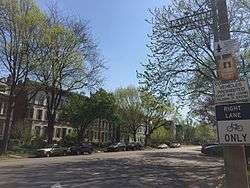
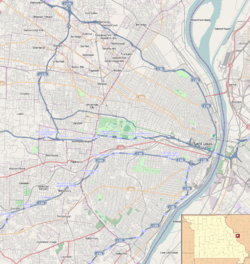
Lafayette Square Historic District (St. Louis)
|
Lafayette Square Historic District (Boundary Increase) | |
 Lafayette Square Historic District | |
   | |
| Location | Roughly bounded by Hickory and 18th Sts., Jefferson and Lafayette Aves. in St. Louis, Missouri (original); roughly bounded by Chouteau Ave., Dolman, Lafayette Ave., and S. Eighteenth St. and Vail Pl. and McKay Pl., St. Louis (boundary increase) |
|---|---|
| Coordinates | 38°37′3″N 90°12′45″W / 38.61750°N 90.21250°WCoordinates: 38°37′3″N 90°12′45″W / 38.61750°N 90.21250°W |
| Architect | Raedner, Frederick W. Et al. |
| Architectural style | Late 19th and 20th Century Revivals, Second Empire, Italianate, Romanesque |
| NRHP reference # | 72001557 (original), 86002127 (boundary increase) [1] |
| Added to NRHP | June 28, 1972 (original), July 24, 1986 (boundary increase) |
Lafayette Square Historic District is a historic district roughly bounded by Hickory and 18th Sts., Jefferson and Lafayette Aves. in St. Louis, Missouri. Buildings in the district include a department store, a single dwelling, a public park, and a specialty store. The district was added to the National Register of Historic Places in 1972. A boundary increase in 1986 added an area roughly bounded by Chouteau Ave., Dolman, Lafayette Ave., and S. Eighteenth St. and Vail Pl. and McKay Pl. Buildings in the boundary increase include single and multiple dwellings, a manufacturing facility and a specialty store.
See also
References
- ↑ National Park Service (2009-03-13). "National Register Information System". National Register of Historic Places. National Park Service.
| Topics | |
|---|---|
| Lists by states |
|
| Lists by insular areas | |
| Lists by associated states | |
| Other areas | |
| |
This article is issued from
Wikipedia.
The text is licensed under Creative Commons - Attribution - Sharealike.
Additional terms may apply for the media files.