Lackey, Kentucky
| Lackey, Kentucky | |
|---|---|
| Unincorporated community | |
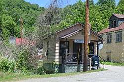 Lackey post office | |
 Lackey Location within the state of Kentucky  Lackey Lackey (the US) | |
| Coordinates: 37°28′6″N 82°49′44″W / 37.46833°N 82.82889°WCoordinates: 37°28′6″N 82°49′44″W / 37.46833°N 82.82889°W | |
| Country | United States |
| State | Kentucky |
| County | Floyd |
| Elevation | 827 ft (252 m) |
| Time zone | UTC-5 (Eastern (EST)) |
| • Summer (DST) | UTC-4 (EST) |
| ZIP codes | 41643 |
| GNIS feature ID | 495888[1] |
Lackey is an unincorporated community in Floyd County, Kentucky, United States. Lackey was home to a pack horse library as part of the Pack Horse Library Project in the late 1930s and early 1940s.[2]
References
- ↑ U.S. Geological Survey Geographic Names Information System: Lackey, Kentucky
- ↑ "Packhorse Librarian to Broaden Service". The Courier-Journal. 12 March 1939. Retrieved 3 September 2017 – via Newspapers.com.
Municipalities and communities of Floyd County, Kentucky, United States | ||
|---|---|---|
| Cities | 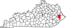 | |
| CDPs | ||
| Other unincorporated communities |
| |
| Footnotes | ‡This populated place also has portions in an adjacent county or counties. | |
This article is issued from
Wikipedia.
The text is licensed under Creative Commons - Attribution - Sharealike.
Additional terms may apply for the media files.