Lac-du-Cerf, Quebec
| Lac-du-Cerf | |
|---|---|
| Municipality | |
 | |
 Location within Antoine-Labelle RCM | |
 Lac-du-Cerf Location in central Quebec | |
| Coordinates: 46°18′N 75°30′W / 46.300°N 75.500°WCoordinates: 46°18′N 75°30′W / 46.300°N 75.500°W[1] | |
| Country |
|
| Province |
|
| Region | Laurentides |
| RCM | Antoine-Labelle |
| Constituted | January 1, 1955 |
| Government[2] | |
| • Mayor | Pauline Ouimet |
| • Federal riding | Laurentides—Labelle |
| • Prov. riding | Labelle |
| Area[2][3] | |
| • Total | 94.40 km2 (36.45 sq mi) |
| • Land | 73.14 km2 (28.24 sq mi) |
| Population (2011)[3] | |
| • Total | 415 |
| • Density | 5.7/km2 (15/sq mi) |
| • Pop 2006-2011 |
|
| • Dwellings | 479 |
| Time zone | UTC−5 (EST) |
| • Summer (DST) | UTC−4 (EDT) |
| Postal code(s) | J0W 1S1 |
| Area code(s) | 819 |
| Highways |
|
| Website |
www |
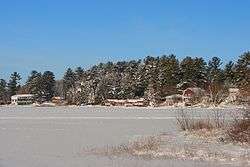
Lac-du-Cerf is a municipality in the Laurentides region of Quebec, Canada, part of the Antoine-Labelle Regional County Municipality. It is located on and named after Lac du Cerf (Deer Lake).
Demographics
Population trend:[4]
- Population in 2011: 415 (2006 to 2011 population change: -2.1%)
- Population in 2006: 424 (2001 to 2006 population change: 1.0%)
- Population in 2001: 420
- Population in 1996: 425
- Population in 1991: 409
Private dwellings occupied by usual residents: 227 (total dwellings: 479)
Mother tongue:
- English as first language: 5%
- French as first language: 95%
- English and French as first language: 0%
- Other as first language: 0%
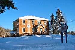
Municipal Hall of Lac-du-Cerf
See also
References
- ↑ Reference number 33070 of the Commission de toponymie du Québec (in French)
- 1 2 Geographic code 79015 in the official Répertoire des municipalités (in French)
- 1 2 Statistics Canada 2011 Census - Lac-du-Cerf census profile
- ↑ Statistics Canada: 1996, 2001, 2006, 2011 census
Adjacent Municipal Subdivisions | |
|---|---|
| Cities/towns | |
|---|---|
| Municipalities | |
| Villages | |
| Unorganized territories | |
| |
This article is issued from
Wikipedia.
The text is licensed under Creative Commons - Attribution - Sharealike.
Additional terms may apply for the media files.