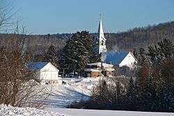
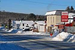
Kiamika, Quebec
| Kiamika | |
|---|---|
| Municipality | |
 | |
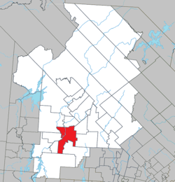 Location within Antoine-Labelle RCM | |
 Kiamika Location in central Quebec | |
| Coordinates: 46°25′N 75°23′W / 46.417°N 75.383°WCoordinates: 46°25′N 75°23′W / 46.417°N 75.383°W[1] | |
| Country |
|
| Province |
|
| Region | Laurentides |
| RCM | Antoine-Labelle |
| Settled | 1860s |
| Constituted | January 3, 1898 |
| Government[2] | |
| • Mayor | Michel Dion |
| • Federal riding | Laurentides—Labelle |
| • Prov. riding | Labelle |
| Area[2][3] | |
| • Total | 362.40 km2 (139.92 sq mi) |
| • Land | 339.89 km2 (131.23 sq mi) |
| Population (2011)[3] | |
| • Total | 772 |
| • Density | 2.3/km2 (6/sq mi) |
| • Pop 2006-2011 |
|
| • Dwellings | 482 |
| Time zone | UTC−5 (EST) |
| • Summer (DST) | UTC−4 (EDT) |
| Postal code(s) | J0W 1G0 |
| Area code(s) | 819 |
| Highways |
|
| Website |
www |
Kiamika is a municipality in the Laurentides region of Quebec, Canada, part of the Antoine-Labelle Regional County Municipality.
Joseph Montferrand (1802-1864), a logger of imposing stature and extraordinary physical strength, was from Kiamika.[1]
Etymology
The municipality is named after the Kiamika River, which flows through its territory and is a tributary of the Du Lièvre River. This name, mentioned by Stanislas Drapeau as Kiamica and appearing on a map of Quebec by Eugène Taché from 1870, comes from the Algonquin word kickiamika meaning "steep cut below the water", from kicki (steep cut) and amick (below the water).[1]
However, an alternate meaning may be "deep and quiet river", from the roots kiam (deep) and ka (quiet).[1][4]
History
In 1883, the Colonization Society of Montarville was founded and took possession of the area in 1884. Settlers established on the banks of the Du Lièvre River, about 11 km south of Val-Barrette, the mission of Saint-Gérard-de-Kiamika, also called Saint-Gérard-de-Montarville. A year later its post office opened. In 1890, the Kiamika Township is proclaimed.[1]
In 1898, the Township Municipality of Kiamika is formed. In 1920, the mission received its status as a parish. In 1994, it changed its statutes and officially became the Municipality of Kiamika.[1]
Demographics
Population trend:[5]
- Population in 2011: 772 (2006 to 2011 population change: -0.9%)
- Population in 2006: 779 (2001 to 2006 population change: 8.8%)
- Population in 2001: 716
- Population in 1996: 722
- Population in 1991: 651
Private dwellings occupied by usual residents: 345 (total dwellings: 482)
Mother tongue:[6]
- English as first language: 15
- French as first language: 750
- English and French as first language: 0
- Other as first language: 0
See also
References
- 1 2 3 4 5 6 "Kiamika (Municipalité)" (in French). Commission de toponymie du Québec. Retrieved 2009-08-21.
- 1 2 Geographic code 79025 in the official Répertoire des municipalités (in French)
- 1 2 Statistics Canada 2011 Census - Kiamika census profile
- ↑ "Notre histoire" (in French). Municipalité de kiamika. Archived from the original on 2010-03-16. Retrieved 2009-08-21.
- ↑ Statistics Canada: 1996, 2001, 2006, 2011 census
- ↑ http://www12.statcan.gc.ca/census-recensement/2011/dp-pd/prof/details/page.cfm?Lang=E&Geo1=CSD&Code1=2479025&Geo2=PR&Code2=24&Data=Count&SearchText=Kiamika&SearchType=Begins&SearchPR=01&B1=All&Custom=
External links

Adjacent Municipal Subdivisions | |
|---|---|
| Cities/towns | |
|---|---|
| Municipalities | |
| Villages | |
| Unorganized territories | |
| |