Labuerda
| Labuerda (Spanish) A Buerda (Aragonese) | |||
|---|---|---|---|
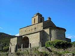 Church of San Vicente. | |||
| |||
 Labuerda (Spanish) Location in Spain | |||
| Coordinates: 42°27′5″N 0°8′18″E / 42.45139°N 0.13833°ECoordinates: 42°27′5″N 0°8′18″E / 42.45139°N 0.13833°E | |||
| Country | Spain | ||
| Autonomous community | Aragon | ||
| Province | Huesca | ||
| Comarca | Sobrarbe | ||
| Government | |||
| • Mayor | Enrique Campo Sanz | ||
| Area | |||
| • Total | 18 km2 (7 sq mi) | ||
| Elevation | 569 m (1,867 ft) | ||
| Population (2009) | |||
| • Total | 172 | ||
| • Density | 9.6/km2 (25/sq mi) | ||
| Time zone | UTC+1 (CET) | ||
| • Summer (DST) | UTC+2 (CEST) | ||

Labuerda (in Aragonese: A Buerda;[1] and officially "Labuerda-A Buerda"[2]) is a municipality located in the province of Huesca, Aragon, Spain. According to the 2009 data from INE, the municipality has a population of 172 inhabitants.
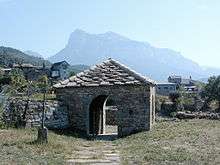
Exconjuratory in San Vicente de Labuerda with the massive Peña Montañesa towering behind it
Villages
- Labuerda, the main town
- San Vicente de Labuerda, which includes the municipality's main attraction, the church of San Vicente. The building has a 12th-century Romanesque nucleus, including the nave, presbytery and the semicircular apse. In the 16th century the side chapels, the sacristy and the bell tower were added, and in the 18th century another chapel and a portico.
Twin towns

References
- ↑ As shown in the Legislative Decree 2/2006 of 27 December, of the Government of Aragon, by the revised text of the Law on Comarcal Demarcation of Aragon is approved.
- ↑ (in Spanish) «Law 5/2003 of creation of the Comarca of Sobrarbe in a program of the Government of Aragon, published in the BOE of February 26, 2003. Consulted the March 06, 2010.
External links
![]()
Municipalities of Sobrarbe | ||
|---|---|---|
1Shared capitals of the comarca | ||
This article is issued from
Wikipedia.
The text is licensed under Creative Commons - Attribution - Sharealike.
Additional terms may apply for the media files.