Peña Montañesa
| Peña Montañesa | |
|---|---|
 | |
| Highest point | |
| Elevation | 2,295 m (7,530 ft) |
| Listing | List of mountains in Aragon |
| Coordinates | 42°31′14″N 00°13′55″E / 42.52056°N 0.23194°ECoordinates: 42°31′14″N 00°13′55″E / 42.52056°N 0.23194°E |
| Geography | |
 Peña Montañesa Spain | |
| Location | Sobrarbe (Aragon) |
| Parent range | Sierra Ferrera |
| Geology | |
| Mountain type | Conglomerate |
| Climbing | |
| Easiest route | From Pueyo de Araguás |
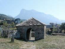
Exconjuratory in San Vicente de Labuerda with the Peña Montañesa towering behind it
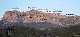
The Peña Montañesa (Aragonese: Penya Montanyesa) is a conspicuous rocky mountainous outcrop of the Pre-Pyrenees. It is located east of the valley of the Cinca, in the Sobrarbe comarca, Aragon, Spain.[1] The ridge's highest summit is 2295 m high. The village of Laspuña is located at the feet of the mountain.
The summits on the mountain offer excellent views of some of the main peaks of the Pyrenees in the north.
The Peña Montañesa was one of the strongholds of Spanish Republican resistance against invading troops supporting General Franco during the Bolsa de Bielsa episode.[2]
The ruins of the Real Monasterio de San Victorián are located in El Pueyo de Araguás, at the foot of the Peña Montañesa.
See also
References
External links
| Wikimedia Commons has media related to Peña Montañesa. |
This article is issued from
Wikipedia.
The text is licensed under Creative Commons - Attribution - Sharealike.
Additional terms may apply for the media files.