L'Île-Bizard–Sainte-Geneviève
| L'Île-Bizard–Sainte-Geneviève | ||
|---|---|---|
| Borough of Montreal | ||
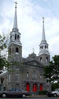 Église Sainte-Geneviève. | ||
| ||
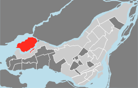 Location of L'Île-Bizard–Sainte-Geneviève on Island of Montreal. (Gray areas indicate demerged municipalities). | ||
| Country |
| |
| Province |
| |
| Region | Montréal | |
| Established | January 01, 2006 | |
| Electoral Districts Federal |
Pierrefonds—Dollard Lac-Saint-Louis | |
| Provincial | Nelligan | |
| Government[1][2][3] | ||
| • Type | Borough | |
| • Mayor | Normand Marinacci | |
| • Federal MPs |
Frank Baylis (LPC) Francis Scarpaleggia (LPC) | |
| • Quebec MNA | Martin Coiteux (PLQ) | |
| Area[4] | ||
| • Land | 23.63 km2 (9.12 sq mi) | |
| Population (2011)[4][5] | ||
| • Total | 18,097 | |
| • Density | 765.8/km2 (1,983/sq mi) | |
| • Change (2006-2011) |
| |
| • Dwellings (2006) | 6,648 | |
| Time zone | UTC-5 (EST) | |
| • Summer (DST) | UTC-4 (EDT) | |
| Postal code(s) | H9J | |
| Area code(s) | (514) and (438) | |
| Website | ville.montreal.qc.ca/ lilebizardsaintegenevieve | |

L'Île-Bizard–Sainte-Geneviève (French pronunciation: [lil bizaʁ sɛ̃t ʒənvjɛv]) is a borough (arrondissement) of the city of Montreal.
History
On 24 October 1678, the government of Louis de Buade de Frontenac granted Île Bizard, then named Île Bonaventure as a seigniory to Jacques Bizard. This was the first concession on the West Island of Montreal. The village of Sainte-Geneviève was born in the early eighteenth century. Antoine Faucon, father of Saint-Sulpice, participated in the construction of the first church in the village's history. The Municipality of the Village of Sainte-Geneviève was created in 1859.
During the first half of the twentieth century, farmers in Île Bizard and Sainte-Geneviève were then oriented toward gardening. The territory was thus transformed into a garden of Montreal. In 1959, it was incorporated as Ville Sainte-Geneviève.
From the late 1950s, the creation of two major golf courses opened the door to massive sales of land and the abandonment of agriculture, which had become unprofitable. In 1959, the Royal Montreal Golf Club opened, and has since hosted several professional golf tournaments.
Over the last fifty years, urbanization has increased and the population has increased tenfold, especially after the opening of Autoroute 40 that connected the western, central and eastern parts of Montreal.
On January 1, 2002, the municipalities of L'Île-Bizard, Sainte-Geneviève, and Sainte-Anne-de-Bellevue were merged into the city of Montreal as the borough of L'Île-Bizard—Sainte-Geneviève—Sainte-Anne-de-Bellevue. When Sainte-Anne-de-Bellevue voted to demerge from Montreal, the borough was reorganized into its present form on January 1, 2006.
Geography
The borough is composed of the former municipalities of L'Île-Bizard and Sainte-Geneviève. The first is a separate island, the largest of the City of Montreal besides the Island of Montreal itself, and the second is a small area on the Island of Montreal. Sainte-Geneviève has a land border with the borough of Pierrefonds-Roxboro.
The borough is divided into four districts:
- Pierre-Foretier
- Denis-Benjamin-Viger
- Jacques-Bizard
- Sainte-Geneviève
The borough has a land area of 23.63 km² and a population of 17,139 (2001 census).
Government
Municipal
As of the November 5, 2017 Montreal municipal election, the current borough council consists of the following councillors:
| District | Position | Name | Party | |
|---|---|---|---|---|
| — | Borough mayor Montreal city councillor |
Normand Marinacci | Projet Montréal | |
| Denis-Benjamin-Viger | Borough councillor | Christian Larocque | Projet Montréal | |
| Jacques-Bizard | Borough councillor | Robert Samoszewski | Projet Montréal | |
| Pierre-Foretier | Borough councillor | Yves Sarault | Projet Montréal | |
| Sainte-Geneviève | Borough councillor | Suzanne Marceau | Équipe Coderre |
Federal and provincial representation
Part of Sainte-Geneviève lies within the federal riding of Lac-Saint-Louis; Île Bizard and the other half of Sainte-Geneviève lie within the riding of Pierrefonds—Dollard.
Provincially, the borough lies in the electoral district of Nelligan.
Demographics
| Historical populations | ||
|---|---|---|
| Year | Pop. | ±% |
| 1966 | 5,233 | — |
| 1971 | 5,800 | +10.8% |
| 1976 | 6,970 | +20.2% |
| 1981 | 9,131 | +31.0% |
| 1986 | 11,123 | +21.8% |
| 1991 | 14,549 | +30.8% |
| 1996 | 16,377 | +12.6% |
| 2001 | 17,139 | +4.7% |
| 2006 | 17,590 | +2.6% |
| 2011 | 18,097 | +2.9% |
| [6] | ||
| Language | Population | Percentage (%) |
|---|---|---|
| French | 9,715 | 58% |
| English | 5,395 | 32% |
| Other languages | 1,675 | 10% |
Features
Sainte-Geneviève and Île Bizard are connected by the Jacques Bizard Bridge. Île Bizard contains part of the Cap-Saint-Jacques Nature Park as well as the Boisé de l'Île Bizard Nature Park. Sainte-Geneviève's features include the Cégep Gérald-Godin. Plans have been advanced in the past to cross Île Bizard with an autoroute as part of a beltway around Montreal, but these have so far come to nothing mainly out of concern for the island's nature areas.
Pierre Bouvier from Simple Plan was from there. Île Bizard have also produced the francophone musical groups Exterio and Kamakazi
Education
The Commission scolaire Marguerite-Bourgeoys operates Francophone public schools.[8]
Primary schools include:
- École primaire Jacques-Bizard
- École primaire Jonathan-Wilson
- École primaire Sainte-Geneviève (Ouest)
The Lester B. Pearson School Board (LBPSB) operates Anglophone public schools in the area.
The Montreal Public Libraries Network operates the Île-Bizard library.[9]
Notable residents
- Pierre Bouvier, lead vocalist of Pop-Punk band Simple Plan.
- Vincent Lecavalier, professional hockey player.
- Guy Lafleur, former professional hockey player.
- Guy Carbonneau, former head coach of the Montréal Canadiens hockey team.
- Daniel Prudkov, CEO of DP Studios, law school student, political activist.
References
- ↑ Ministère des Affaires Municipales et Régions: L'Île-Bizard–Sainte-Geneviève
- ↑ Parliament of Canada Federal Riding History: PIERREFONDS--DOLLARD (Quebec)
Parliament of Canada Federal Riding History: LAC-SAINT-LOUIS (Quebec) - ↑ Chief Electoral Officer of Québec - 40th General Election Riding Results: NELLIGAN
- 1 2 2006 Statistics Canada Community Profile: L'Île-Bizard, Quebec
2006 Statistics Canada Community Profile: Sainte-Geneviève, Quebec - ↑ "Population totale en 2006 et en 2011 - Variation — Densité" (PDF). Canada 2011 Census (in French). Ville de Montréal. 2012. Retrieved 5 June 2012.
- ↑ "Profil sociodéographique: Arrondissement de L'Ile-Bizard–Sainte-Geneviève" (PDF) (in French). Ville de Montréal. 2013. Retrieved 28 October 2013.
- ↑ http://ville.montreal.qc.ca/portal/page?_pageid=6897,68087652&_dad=portal&_schema=PORTAL
- ↑ "ÉCOLES ET CENTRES." Commission Scolaire Marguerite-Bourgeoys. Retrieved on December 7, 2014.
- ↑ "Par bibliothèque | Par arrondissement." Montreal Public Libraries Network. Retrieved on December 8, 2014.
External links
- Borough website (in French)
See also
Places adjacent to L'Île-Bizard–Sainte-Geneviève | ||||||||||
|---|---|---|---|---|---|---|---|---|---|---|
| ||||||||||
Coordinates: 45°28′59″N 73°52′34″W / 45.483055°N 73.87615°W